Related Research Articles

Hampshire County is a county in the U.S. state of West Virginia. As of the 2010 census, the population was 23,964. Its county seat is Romney, West Virginia's oldest town (1762). The county was created by the Virginia General Assembly in 1754, from parts of Frederick and Augusta Counties (Virginia) and is the state's oldest county. The county lies in both West Virginia's Eastern Panhandle and Potomac Highlands regions.

Berkeley Springs is a town in, and the county seat of, Morgan County, West Virginia, United States, in the state's Eastern Panhandle. In 1776, the Virginia Legislature incorporated a town around the springs and named it Bath. Since 1802, it has been referred to by the name of its original Virginia post office, Berkeley Springs. The population of the town was 800 (estimated). The town is located within the Hagerstown–Martinsburg, MD–WV Metropolitan Statistical Area. Berkeley Springs is a sister city to Bath, Somerset, England.

The Shenandoah River is a tributary of the Potomac River, 55.6 miles (89.5 km) long with two forks approximately 100 miles (160 km) long each, in the U.S. states of Virginia and West Virginia. The principal tributary of the Potomac, the river and its tributaries drain the central and lower Shenandoah Valley and the Page Valley in the Appalachians on the west side of the Blue Ridge Mountains, in northwestern Virginia and the Eastern Panhandle of West Virginia.

The Cacapon River, located in the Appalachian Mountains of West Virginia's Eastern Panhandle region, is an 81.0-mile-long (130.4 km) river known for its fishing, boating, wildlife, and scenery. As part of the Potomac River watershed, it is an American Heritage River.

Okonoko is an unincorporated community in Hampshire County in the U.S. state of West Virginia. Okonoko is located north of Levels on the Potomac River at Bright's Hollow. The community's placename is the only one of its kind within the United States.

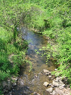
The Little Cacapon River is a 25.1-mile-long (40.4 km) free-flowing tributary of the Potomac River in the center of Hampshire County, West Virginia. Via the Potomac River, its waters are part of the Chesapeake Bay watershed, leading to the Atlantic Ocean. The Little Cacapon enters the Potomac at an elevation of 499 feet (152 m) near the community of Little Cacapon. For the majority of its course the Little Cacapon is a shallow non-navigable stream. It has been historically referred to as both Little Cacapehon and Little Capecaphon. The name is pronounced kə-KAY-pən or KAY-pən.

Little Cacapon is an unincorporated community in Hampshire County in the U.S. state of West Virginia. Little Cacapon is located at the mouth of the Little Cacapon River on the Potomac, east of Okonoko. Okonoko-Little Cacapon Road and Spring Gap-Neals Run Road converge south of Little Cacapon. Because of its key location at the mouth of the Little Cacapon and on the Baltimore and Ohio Railroad, Little Cacapon played important roles in both the French and Indian and American Civil Wars. Generally pronounced kə-KAY-pən. Sometimes, despite the current spelling of the word some locals say KAY-pən.
Dillons Run is a 12.9-mile-long (20.8 km) tributary stream of the Cacapon River, belonging to the Potomac River and Chesapeake Bay watersheds. The stream is located in Hampshire County in the U.S. state of West Virginia's Eastern Panhandle.

Cacapon Mountain runs northwest through Morgan and Hampshire counties in West Virginia's Eastern Panhandle, rising to its greatest elevation of 2,618 feet (798 m) above sea-level at High Point. Cacapon Mountain is a folded mountain ridge, belonging to the Appalachian Ridge and Valley Province. Cacapon Mountain spans 16 miles (26 km) NNE to the Potomac River near Great Cacapon.
Spring Gap Mountain runs southwest northeast through Morgan and Hampshire counties in West Virginia's Eastern Panhandle, rising to its greatest elevation of 2,237 ft (682 m) north of "Spring Gap", from which the mountain takes its name. The gap is the source for Dug Hill Run, a tributary stream of the Little Cacapon River.
Cacapon is a term of Native American origin that means "medicine waters." Most placenames named Cacapon or the variation of Capon are named for the Cacapon River in West Virginia's Eastern Panhandle, United States.
Mill Branch is a 9.1-mile-long (14.6 km) tributary stream of the Cacapon River, belonging to the Potomac River and Chesapeake Bay watersheds. The stream is located in eastern Hampshire County in West Virginia's Eastern Panhandle.

Little Cacapon Mountain is a mountain ridge of the Ridge-and-valley Appalachians in Hampshire County, West Virginia, United States. The mountain takes its name from the Little Cacapon River, a Potomac River tributary that lies on its western flanks. Little Cacapon Mountain reaches its highest point of 1,575 feet (480 m) in the vicinity of Barnes Mill. It spans from the Frenchburg area, where it is joined by Chestnut Oak Ridge, to the Slanesville Pike where Crooked Run forms a gap between Little Cacapon Mountain and Queens Ridge near Higginsville.
Sir Johns Run is an 8.9-mile-long (14.3 km) tributary stream of the Potomac River in Morgan County, West Virginia. For most of its course, Sir Johns Run is a shallow non-navigable stream. It rises on the eastern flanks of Cacapon Mountain and from its source, flows north with Cacapon Mountain to its west and Warm Spring Ridge to its east. During its flow northward through the valley, Sir Johns Run is joined by a number of smaller spring-fed streams. Sir Johns Run empties into the Potomac River at the small community of the same name, Sir Johns Run. The stream takes its name from Sir John St. Clair, a deputy quartermaster present during General Edward Braddock's expedition through the area during the French and Indian War.
Trout Run is an 18.5-mile-long (29.8 km) tributary of the Cacapon River, belonging to the Potomac River and Chesapeake Bay watersheds. The stream is located in Hardy County in West Virginia's Eastern Panhandle. Trout Run rises between Devils Hole Mountain and Great North Mountain near the Virginia state line in the George Washington National Forest. The stream empties into the Cacapon River at Wardensville.
Tonoloway Ridge is a stratigraphic ridge that runs southwest northeast through the U.S. states of Pennsylvania, Maryland, and West Virginia. It reaches its highest elevation above mean sea level of 1,292 feet (393.8 m) at a knob on its southern end in Morgan County, West Virginia. Tonoloway Ridge is separated by gaps at Great Cacapon on the Potomac River and at Little Tonoloway Creek where it is traversed by Interstate 68 in Maryland.

The North River is a tributary of the Cacapon River, belonging to the Potomac River and Chesapeake Bay watersheds. The river is located in Hampshire and Hardy counties in the U.S. state of West Virginia's Eastern Panhandle. The mouth of the North River into the Cacapon is located at Forks of Cacapon. From its headwaters to its mouth, the North River spans 52.4 miles (84.3 km) in length.
References
- ↑ "The Devil's Nose Mountain Information". mountain-forecast.com. Retrieved 2016-05-27.
| This article is about a location in Hampshire County, West Virginia is a stub. You can help Wikipedia by expanding it. |