
Hampshire County is a county in the U.S. state of West Virginia. As of the 2020 census, the population was 23,093. Its county seat is Romney, West Virginia's oldest town (1762). The county was created by the Virginia General Assembly in 1754, from parts of Frederick and Augusta Counties (Virginia) and is the state's oldest county. The county lies in both West Virginia's Eastern Panhandle and Potomac Highlands regions.

The Cacapon River, located in the Appalachian Mountains of West Virginia's Eastern Panhandle region, is an 81.0-mile-long (130.4 km) shallow river known for its fishing, boating, wildlife, hunting, and wilderness scenery. As part of the Potomac River watershed, it is an American Heritage River.
Forks of Cacapon, formerly Forks of Capon, is an unincorporated community in Hampshire County in the U.S. state of West Virginia. The community is named for its location at the confluence of the North River and Cacapon River. Forks of Cacapon is also located at another fork: the crossroads of West Virginia Route 29, West Virginia Route 127, and Frank Haines Road.
Yellow Spring is an unincorporated community in Hampshire County in the U.S. state of West Virginia. According to the 2000 census, the Yellow Spring community has a population of 296. Yellow Spring is named after the "Yellow Spring" located there on the Cacapon River. The community lies at the junction of West Virginia Route 259 and Cacapon River Road. Yellow Spring is sometimes incorrectly listed or referred to as Yellowspring or Yellow Springs.
Slanesville is an unincorporated community in northeastern Hampshire County in the U.S. state of West Virginia. Slanesville is located at the crossroads of Bloomery Pike with Slanesville Pike and Cold Stream Road. Slanesville Pike and Cold Stream Road formerly made up the Springfield Grade Road that ran from Capon Bridge to Springfield. According to the 2000 census, the Slanesville community has a population of 691.
Frenchburg is an unincorporated community in Hampshire County in the U.S. state of West Virginia. Frenchburg is located along the Northwestern Turnpike where the Little Cacapon River is formed by the confluence of the North and South forks of the Little Cacapon east of Shanks. Frenchburg is also the location of the southern terminus of Little Cacapon River Road on U.S. Route 50. Frenchburg is primarily known for the events that took place there during the American Civil War.

The Little Cacapon River is a 25.1-mile-long (40.4 km) free-flowing tributary of the Potomac River in the center of Hampshire County, West Virginia. Via the Potomac River, its waters are part of the Chesapeake Bay watershed, leading to the Atlantic Ocean. The Little Cacapon enters the Potomac at an elevation of 499 feet (152 m) near the community of Little Cacapon. For the majority of its course the Little Cacapon is a shallow non-navigable stream. It has been historically referred to as both Little Cacapehon and Little Capecaphon. The name is pronounced kə-KAY-pən or KAY-pən.
Little Cacapon is an unincorporated community in Hampshire County in the U.S. state of West Virginia. Little Cacapon is located at the mouth of the Little Cacapon River on the Potomac, east of Okonoko. Okonoko-Little Cacapon Road and Spring Gap-Neals Run Road converge south of Little Cacapon. Because of its key location at the mouth of the Little Cacapon and on the Baltimore and Ohio Railroad, Little Cacapon played important roles in both the French and Indian and American Civil Wars. Generally pronounced kə-KAY-pən. Sometimes, despite the current spelling of the word some locals say KAY-pən.
Barnes Mill is an unincorporated community in Hampshire County in the U.S. state of West Virginia. It is located along the Little Cacapon River on Little Cacapon River Road north of Frenchburg. The original "Barnes Mill", from which the community takes its name, was built here on the Little Cacapon in 1813. The community was served by a post office in the 19th century. Barnes Mill was formerly known as Barnes Mills.

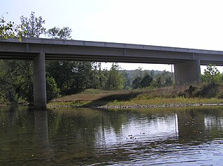
Capon Lake is an unincorporated community in Hampshire County of West Virginia's Eastern Panhandle region. Capon Lake is situated between Yellow Spring and Intermont at the junction of West Virginia Route 259 and Capon Springs Road along the Cacapon River. Capon Springs Run empties into the Cacapon here across from the old Capon Lake Whipple Truss Bridge. Capon Lake takes its name from the Cacapon River's lake-like characteristics there. It was a popular picnic spot for tourists and travelers on the Winchester and Western Railroad.
Intermont is an unincorporated community in Hampshire County, West Virginia, United States, located along West Virginia Route 259 on the Cacapon River. It was originally known as Mutton Run until 1920, when its name was changed to Intermont. Because of Mutton Run's location on the Winchester and Western Railroad, it may have been renamed after the Intermountain Construction Company that completed the railroad from Winchester to Wardensville. Their post office is closed.

West Virginia Route 127 is an east–west state highway located in northeast West Virginia. The western terminus is at West Virginia Route 29 near Forks of Cacapon in Hampshire County. The eastern terminus is at the Virginia state line west of U.S. Route 522 and east of Good, where WV 127 continues eastward as State Route 127.

West Virginia Route 259 is a state highway in the U.S. state of West Virginia. The state highway runs 45.6 miles (73.4 km) from the Virginia state line near Mathias north to the Virginia state line at High View. At both termini, the road continues as Virginia State Route 259. WV 259 passes through Hardy and Hampshire counties and runs concurrently with WV 55 on Corridor H between Baker and Wardensville.
Cold Stream is an unincorporated community in Hampshire County in the U.S. state of West Virginia. Cold Stream is located north of Capon Bridge on Cold Stream Road. Referred to as Edwards Run in its past, the community of Cold Stream is in proximity to where Edwards Run empties into the Cacapon River. The community most likely took its name from a nearby stream of the same name noted for the cold water it contains. Their post office has been closed.
Largent is an unincorporated community village located chiefly in Morgan County and partly in Hampshire County in the U.S. state of West Virginia. Largent is located on the Cacapon River, approximately 18 miles southwest of Berkeley Springs along Cacapon Road. It is located by Old Enon Cemetery, Stony Creek, and the Cacapon River. Largent's original town name was Enon. It was most likely renamed when Postal Service found another town of Enon elsewhere in the state. The Enon name is found in local church and cemetery names. The Enon school is found on USGS maps from 1914 through 1923. The school has been open at least since the 1930s. The Baileys bought the building in 1958 and it has been a residence since.
Spring Gap Mountain runs southwest northeast through Morgan and Hampshire counties in West Virginia's Eastern Panhandle, rising to its greatest elevation of 2,237 ft (682 m) north of "Spring Gap", from which the mountain takes its name. The gap is the source for Dug Hill Run, a tributary stream of the Little Cacapon River.
Orleans Cross Roads is an unincorporated community hamlet that lies on the western flanks of Sideling Hill on the Potomac River in Morgan County, West Virginia. To its south, Rockwell Run, a mountain stream fed by springs, empties into the Potomac. Orleans Cross Roads lies along the old Baltimore and Ohio Railroad directly across the river from Little Orleans. It is accessible by way of Orleans Road from Cacapon Road via Detour Road.
Davis Ford is an unincorporated community on the Cacapon River in Hampshire County in the U.S. state of West Virginia. It lies primarily on Cacapon River Road at the ford from which it takes its name. The Yellow Spring post office serves the Davis Ford community.

The North River is a tributary of the Cacapon River, belonging to the Potomac River and Chesapeake Bay watersheds. The river is located in Hampshire and Hardy counties in the U.S. state of West Virginia's Eastern Panhandle. The mouth of the North River into the Cacapon is located at Forks of Cacapon. From its headwaters to its mouth, the North River spans 52.4 miles (84.3 km) in length.
The Lost River is a 31.1-mile-long (50.1 km) river in the Appalachian Mountains of Hardy County in West Virginia's Eastern Panhandle region. The Lost River is geologically the same river as the Cacapon River: It flows into an underground channel northeast of McCauley along West Virginia Route 259 at "the Sinks" and reappears near Wardensville as the Cacapon. The source of the Lost River lies south of Mathias near the West Virginia/Virginia border. Along with the Cacapon and North rivers, the Lost River serves as one of the three main segments of the Cacapon River and its watershed.


