U.S. Route 522 is a spur route of US 22 in the U.S. states of Virginia, West Virginia, Maryland, and Pennsylvania. The U.S. Highway travels in a north-south direction, and runs 308.59 miles (496.63 km) from US 60 near Powhatan, Virginia, to its northern terminus at US 11 and US 15 near Selinsgrove, Pennsylvania. US 522 serves many small cities and towns in the Piedmont, Blue Ridge Mountains, and northern Shenandoah Valley of Virginia. The highway serves the Virginia communities of Goochland, Mineral, Culpeper, the town of Washington, and Front Royal and the independent city of Winchester. US 522 then follows the Ridge-and-Valley Appalachians north and then east through the Eastern Panhandle of West Virginia, a 2-mile-wide (3.2 km) stretch of Western Maryland, and South Central Pennsylvania to its terminus in the Susquehanna Valley. The highway serves Berkeley Springs, West Virginia; Hancock, Maryland; and the Pennsylvania communities of McConnellsburg, Mount Union, Lewistown, and Middleburg.

The Cacapon River, located in the Appalachian Mountains of West Virginia's Eastern Panhandle region, is an 81.0-mile-long (130.4 km) river known for its fishing, boating, wildlife, and scenery. As part of the Potomac River watershed, it is an American Heritage River.
Yellow Spring is an unincorporated community in Hampshire County in the U.S. state of West Virginia. According to the 2000 census, the Yellow Spring community has a population of 296. Yellow Spring is named after the "Yellow Spring" located there on the Cacapon River. The community lies at the junction of West Virginia Route 259 and Cacapon River Road. Yellow Spring is sometimes incorrectly listed or referred to as Yellowspring or Yellow Springs.

Little Cacapon is an unincorporated community in Hampshire County in the U.S. state of West Virginia. Little Cacapon is located at the mouth of the Little Cacapon River on the Potomac, east of Okonoko. Okonoko-Little Cacapon Road and Spring Gap-Neals Run Road converge south of Little Cacapon. Because of its key location at the mouth of the Little Cacapon and on the Baltimore and Ohio Railroad, Little Cacapon played important roles in both the French and Indian and American Civil Wars. Generally pronounced kə-KAY-pən. Sometimes, despite the current spelling of the word some locals say KAY-pən.
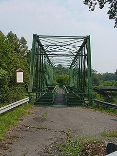
Capon Lake is an unincorporated community in Hampshire County of West Virginia's Eastern Panhandle region. Capon Lake is situated between Yellow Spring and Intermont at the junction of West Virginia Route 259 and Capon Springs Road along the Cacapon River. Capon Springs Run empties into the Cacapon here across from the old Capon Lake Whipple Truss Bridge. Capon Lake takes its name from the Cacapon River's lake-like characteristics there. It was a popular picnic spot for tourists and travelers on the Winchester and Western Railroad.
Lehew is an unincorporated community in Hampshire County, West Virginia, United States on the Virginia state line. Lehew is located on Timber Ridge along West Virginia Route 259 at its crossroads with H.G. Brill Road and White Pine Ridge Road.
Sleepy Creek is a 44.0-mile-long (70.8 km) tributary of the Potomac River in the United States, belonging to the Chesapeake Bay's watershed. The stream rises in Frederick County, Virginia, and flows through Morgan County, West Virginia before joining the Potomac near the community of Sleepy Creek.
Capon Springs Station was an unincorporated community hamlet in Hampshire County in the U.S. state of West Virginia centered on a station on the Winchester and Western Railroad. Located along Capon Springs Road where Dry Run meets Capon Springs Run on the western end of Middle Ridge, Capon Springs Station served as a stop for guests at the Capon Springs Resort in Capon Springs and people picnicking at Capon Lake on the Cacapon River.

Gore is an unincorporated community in western Frederick County, Virginia, United States, located off the Northwestern Turnpike on Gore Road west of Winchester. The community is nestled in the Back Creek valley. It has been called "Back Creek".
Baker Mountain is a mountain ridge in southeastern Hampshire County, West Virginia. The mountain runs southwest northeast between Yellow Spring and the Hardy County line. Baker Mountain is flanked to its east by the Cacapon River with West Virginia Route 259 running parallel between the two. Its forests were once used as a major source of timber for the Baltimore and Ohio Railroad's rail ties. For this reason, the Winchester and Western Railroad was constructed through the Capon Valley in the 1920s to haul the timber harvested in the region to Winchester, Virginia for railroad tie production. The communities of Capon Lake and Intermont lie at the foot of Baker Mountain on the Cacapon.
Millen is an unincorporated community in Hampshire County, West Virginia, United States between Donaldson and Green Spring on Green Spring Road and the South Branch Valley Railroad. Millen is nestled in Green Spring Valley along Green Spring Run between Green Spring Ridge and Valley Mountain.
Dillons Run was an unincorporated community in Hampshire County, West Virginia, United States. It is located at the intersection of Dillons Run Road and Haines Road along Dillons Run stream from which it takes its name. Dillons Run no longer has its own post office in operation. It was originally known as Luptons Mill.
Pancake is an unincorporated community in Hampshire County in the U.S. state of West Virginia. Pancake is located on Pancake Road, once connecting to South Branch River Road across the South Branch Potomac River. Pancake was once a stop along the South Branch Valley Railroad and is named for the Pancake family in the immediate area. The Pancake Post Office has been closed.

Donaldson is an unincorporated community in Hampshire County in the U.S. state of West Virginia. It is located in Green Spring Valley on Green Spring Road between Green Spring and Springfield. Donaldson was once a thriving railroad community along the South Branch Valley Railroad with its own school and post office in operation.
Jericho is an unincorporated community in Hampshire County in the U.S. state of West Virginia on the Virginia line. It is located on West Virginia Route 259 between High View and Lehew atop Timber Ridge.
Shiloh is an unincorporated community in Hampshire County in the U.S. state of West Virginia. Shiloh is located on Gore Road near the Virginia line. Shiloh was once a stop on the old Winchester and Western Railroad. The community was named for Shiloh, a site mentioned in the Hebrew Bible that contained the Ark of the Covenant.
Smith Crossroads is an unincorporated community in Morgan County in the U.S. state of West Virginia's Eastern Panhandle. The hamlet lies at the crossroads of the Winchester Grade Road with County Routes 26 and 13/1. According to the Geographic Names Information System, Smith Crossroads has also been referred to as Smiths Corners, Smiths Cross Roads, and Smiths Forks.
Green Spring Run is an 8.9-mile-long (14.3 km) tributary stream of the North Branch Potomac River in Hampshire County in the U.S. state of West Virginia. Green Spring Run rises in Greenwood Hollow north of Springfield and meanders northeast through Green Spring Valley. The South Branch Valley Railroad and Green Spring Road run parallel to the stream. It runs through the community of Green Spring, from which the stream takes its name. From Green Spring, Green Spring Run flows east where it reaches its confluence with the North Branch Potomac shortly before the North Branch joins with the South Branch Potomac River to form the Potomac River.

Abrams Creek is an 11.2-mile-long (18.0 km) tributary stream of Opequon Creek in Frederick County and the independent city of Winchester in Virginia. Abrams Creek rises north of Round Hill and flows in a southeasterly direction through Winchester. From Winchester, Abrams Creek flows east into Opequon Creek. The stream was originally known as Abraham's Creek.
The Lost River is a 31.1-mile-long (50.1 km) river in the Appalachian Mountains of Hardy County in West Virginia's Eastern Panhandle region. The Lost River is geologically the same river as the Cacapon River: It flows into an underground channel northeast of McCauley along West Virginia Route 259 at "the Sinks" and reappears near Wardensville as the Cacapon. The source of the Lost River lies south of Mathias near the West Virginia/Virginia border. Along with the Cacapon and North rivers, the Lost River serves as one of the three main segments of the Cacapon River and its watershed.