
Levels is an unincorporated community in Hampshire County in the U.S. state of West Virginia. According to the 2000 census, the Levels community has a population of 147. It is home to John J. Cornwell Elementary School.

Sector is an unincorporated community in Hampshire County in the U.S. state of West Virginia. It is located along the west bank of the South Branch Potomac River on Fleming-Sector Road across the river from the community of Glebe.
Glebe was an unincorporated community in Hampshire County, West Virginia, United States. It is situated at the lower mouth of the Trough, a gorge of the South Branch Potomac River, and is about 9.5 miles (15.3 km) southwest of Romney on South Branch River Road. The community received its name from the old stone glebehouse (parsonage) that was constructed there in the late 18th century. The stone house later became the Hampshire County Poor Farm and remains standing. The community of Sector lies directly across the river.
South Branch Depot also known as South Branch is an unincorporated community in Hampshire County in the U.S. state of West Virginia. Originally known as Forks of Potomac because of its proximity to the confluence of the North and South Branches of the Potomac River and then later in the early 20th century as French's Station and then simply South Branch, South Branch Depot served as a depot and post office on the Baltimore & Ohio Railroad since the railroad was constructed there in the 1840s. Today, South Branch Depot may only be reached from Levels by way of Frenches Station Road.

Wappocomo is an unincorporated community in Hampshire County in the U.S. state of West Virginia. The community is located south of Springfield on West Virginia Route 28 at Hanging Rocks along the South Branch Potomac River. Wappocomo has also historically been referred to as The Rocks, Wapocoma, and Wapocomo.
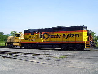
The South Branch Valley Railroad consists of a 52.4 mile (84.33 km) length of railroad in the U.S. state of West Virginia extending north along the South Branch Potomac River from Petersburg to the CSXT mainline at Green Spring adjacent to the Potomac River. At Green Spring, the CSXT mainline connects the SBVR to Cumberland, Maryland to the west and Martinsburg, West Virginia to the east. SBVR has been owned and operated by the West Virginia State Rail Authority (SRA) since it was sold by the Baltimore & Ohio Railroad on October 11, 1978. Upon purchasing the B&O's South Branch line, West Virginia became the first state in the United States to both own and operate a commercial freight railroad. In 1985, major flooding of the South Branch Valley destroyed most of the rail line, including all three bridges that crossed the South Branch Potomac River. Despite talk of shutting down the railroad after the flood, reconstruction began two years later.

The Trough is a 6-mile long wooded gorge carved by the South Branch Potomac River (SBPR) and situated in the Allegheny Mountains of Hampshire and Hardy Counties, West Virginia, USA. The area was the site of a 1756 skirmish of the French and Indian War, known as the "Battle of the Trough".
Sleepy Creek is a 44.0-mile-long (70.8 km) tributary of the Potomac River in the United States, belonging to the Chesapeake Bay's watershed. The stream rises in Frederick County, Virginia, and flows through Morgan County, West Virginia before joining the Potomac near the community of Sleepy Creek.

Blues Beach is an unincorporated community in Hampshire County in the U.S. state of West Virginia. Blues Beach is a predominantly river camp community located south of Springfield and north of Wappocomo on West Virginia Route 28 along the South Branch Potomac River. Blues Beach is also the location of the John Blue Bridge, commonly referred to as "Blue Beach Bridge." Long Road intersects with WV 28 here.
Pancake is an unincorporated community in Hampshire County in the U.S. state of West Virginia. Pancake is located on Pancake Road, once connecting to South Branch River Road across the South Branch Potomac River. Pancake was once a stop along the South Branch Valley Railroad and is named for the Pancake family in the immediate area. The Pancake Post Office has been closed.

Donaldson is an unincorporated community in Hampshire County in the U.S. state of West Virginia. It is located in Green Spring Valley on Green Spring Road between Green Spring and Springfield. Donaldson was once a thriving railroad community along the South Branch Valley Railroad with its own school and post office in operation.

Mill Creek is a 14.0-mile-long (22.5 km) tributary stream of the South Branch Potomac River, belonging to the Potomac River and Chesapeake Bay watersheds. The stream is located in Hampshire County in West Virginia's Eastern Panhandle. Mill Creek flows into the South Branch west of Romney Bridge near Vanderlip along the Northwestern Turnpike.
Hampshire is an unincorporated community on the North Branch Potomac River in Mineral County, West Virginia. It is part of the Cumberland, MD-WV Metropolitan Statistical Area. It is located to the south of Bloomington and to the west of Beryl.
Green Spring Run is an 8.9-mile-long (14.3 km) tributary stream of the North Branch Potomac River in Hampshire County in the U.S. state of West Virginia. Green Spring Run rises in Greenwood Hollow north of Springfield and meanders northeast through Green Spring Valley. The South Branch Valley Railroad and Green Spring Road run parallel to the stream. It runs through the community of Green Spring, from which the stream takes its name. From Green Spring, Green Spring Run flows east where it reaches its confluence with the North Branch Potomac shortly before the North Branch joins with the South Branch Potomac River to form the Potomac River.

Big Run is a 4.4-mile-long (7.1 km) tributary stream of the South Branch Potomac River, belonging to the Potomac River and Chesapeake Bay watersheds. Big Run flows through the city of Romney and the campus of the West Virginia Schools for the Deaf and Blind in Hampshire County, West Virginia. The stream is known by local residents as Town Run and Town Creek.
Grace is an unincorporated community on the South Branch Potomac River in Hampshire County, West Virginia, United States. Grace lies at the intersection of Grace's Cabin Road and West Virginia Route 28 across the South Branch from Blues Beach.
Vance is an unincorporated community in Hampshire County in the U.S. state of West Virginia. Vance lies on the South Branch Potomac River. Most of its residents reside along West Virginia Route 28. Buffalo Creek empties into the South Branch at Vance.
Ridgedale is an unincorporated community in Hampshire County in the U.S. state of West Virginia. It is located within a horsehoe bend in the South Branch Potomac River between the communities of Blues Beach and Wappocomo. Ridgedale is named for the recently restored 1835 plantation built by George W. Washington, also known as Washington Bottom Farm. Washington's plantation obtained its name due to its location at the foot of Mill Creek Ridge at its northernmost extent. Ridgedale is located off the South Branch Valley Railroad and is accessible from West Virginia Route 28 by way of Washington Road. Ridgedale once had a post office and a school in operation there. Today, Ridgedale consists of the old Washington farm and a number of summer camps, cabins, and vacation homes on the South Branch.

Wickham is an unincorporated community in Raleigh County, West Virginia, United States. Its post office is closed.


