
Hampshire County is a county in the U.S. state of West Virginia. As of the 2020 census, the population was 23,093. Its county seat is Romney, West Virginia's oldest town (1762). The county was created by the Virginia General Assembly in 1754, from parts of Frederick and Augusta Counties (Virginia) and is the state's oldest county. The county lies in both West Virginia's Eastern Panhandle and Potomac Highlands regions.

The South Branch Potomac River has its headwaters in northwestern Highland County, Virginia near Hightown along the eastern edge of the Allegheny Front. After a river distance of 139 miles (224 km), the mouth of the South Branch lies east of Green Spring in Hampshire County, West Virginia where it meets the North Branch Potomac River to form the Potomac.
The Northwestern Turnpike is a historic road in West Virginia, important for being historically one of the major roads crossing the Appalachians, financed by the Virginia Board of Public Works in the 1830s. In modern times, west of Winchester, Virginia, U.S. Route 50 follows the path of the Northwestern Turnpike into West Virginia, whose major Corridor D project follows the western section of the original Northwestern Turnpike.

Springfield is a census-designated place (CDP) in northwestern Hampshire County in the U.S. state of West Virginia. As of the 2010 census, Springfield had a population of 477. Springfield is located north of Romney along West Virginia Route 28 at its junction with Green Spring Road and Springfield Pike. It is currently considering incorporation.

Green Spring is a census-designated place (CDP) and railroad town in Hampshire County, West Virginia, United States. As of the 2010 census, its population was 218. Green Spring is located north of Springfield on Green Spring Road near the confluence of the North and South Branches of the Potomac River. Green Spring is also the location of the South Branch Valley Railroad's terminus with the old Baltimore & Ohio Railroad mainline. Green Spring is the site of a one-lane low-water toll bridge that connects Green Spring Road to Maryland Route 51 in Oldtown, Allegany County, Maryland. This bridge is one of only 17 privately owned toll bridges in the United States. The toll for the bridge is currently US$1.50.

Wappocomo is an unincorporated community in Hampshire County in the U.S. state of West Virginia. The community is located south of Springfield on West Virginia Route 28 at Hanging Rocks along the South Branch Potomac River. Wappocomo has also historically been referred to as The Rocks, Wapocoma, and Wapocomo.
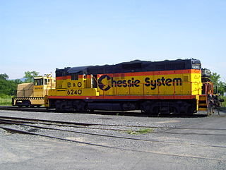
The South Branch Valley Railroad is a 52.4-mile-long (84.3 km) railroad in the Eastern Panhandle of West Virginia. The branch line, which parallels the South Branch Potomac River, runs north from Petersburg to Green Spring, where it connects to the national rail network at a junction with the CSX Cumberland Subdivision.

Blues Beach is an unincorporated community in Hampshire County in the U.S. state of West Virginia. Blues Beach is a predominantly river camp community located south of Springfield and north of Wappocomo on West Virginia Route 28 along the South Branch Potomac River. Blues Beach is also the location of the John Blue Bridge, commonly referred to as "Blue Beach Bridge." Long Road intersects with WV 28 here.
Pancake is an unincorporated community in Hampshire County in the U.S. state of West Virginia. Pancake is located on Pancake Road, once connecting to South Branch River Road across the South Branch Potomac River. Pancake was once a stop along the South Branch Valley Railroad and is named for the Pancake family in the immediate area. The Pancake Post Office has been closed.

Mill Creek is a 14.0-mile-long (22.5 km) tributary stream of the South Branch Potomac River, belonging to the Potomac River and Chesapeake Bay watersheds. The stream is located in Hampshire County in West Virginia's Eastern Panhandle. Mill Creek flows into the South Branch west of Romney Bridge near Vanderlip along the Northwestern Turnpike.
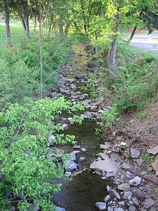
Big Run is a 4.4-mile-long (7.1 km) tributary stream of the South Branch Potomac River, belonging to the Potomac River and Chesapeake Bay watersheds. Big Run flows through the city of Romney and the campus of the West Virginia Schools for the Deaf and Blind in Hampshire County, West Virginia. The stream is known by local residents as Town Run and Town Creek.
Vance is an unincorporated community in Hampshire County in the U.S. state of West Virginia. Vance lies on the South Branch Potomac River. Most of its residents reside along West Virginia Route 28. Buffalo Creek empties into the South Branch at Vance.
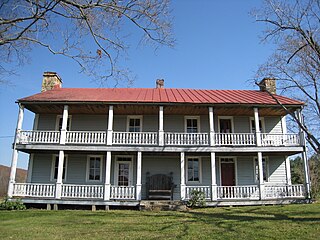
Ridgedale is an unincorporated community in Hampshire County in the U.S. state of West Virginia. It is located within a horseshoe bend in the South Branch Potomac River between the communities of Blues Beach and Wappocomo. Ridgedale is named for the recently restored 1835 plantation built by George W. Washington, also known as Washington Bottom Farm. Washington's plantation obtained its name due to its location at the foot of Mill Creek Ridge at its northernmost extent. Ridgedale is located off the South Branch Valley Railroad and is accessible from West Virginia Route 28 by way of Washington Road. Ridgedale once had a post office and a school in operation there. Today, Ridgedale consists of the old Washington farm and a number of summer camps, cabins, and vacation homes on the South Branch.
Buffalo Creek is a 4.1-mile-long (6.6 km) free-flowing tributary stream of the South Branch Potomac River, itself a tributary of the Potomac River, making it a part of the Chesapeake Bay watershed. Buffalo Creek is located in west-central Hampshire County in the U.S. state of West Virginia. Because the stream flows through several small farms, Buffalo Creek primarily serves agriculture purposes with segments used for livestock watering.

U.S. Route 220 (US 220) is a U.S. Highway that travels from Rockingham, North Carolina, to South Waverly, Pennsylvania. In the state of West Virginia, it travels for 93 miles (150 km) from the Virginia state line two miles (3.2 km) south of Harper to the Maryland state line at Keyser.
Hook's Tavern or Hook Tavern was a late 18th-century tavern along the Northwestern Turnpike east of Capon Bridge in Hampshire County, West Virginia. It was listed on the National Register of Historic Places on April 29, 2011. It burned in an alleged arson on October 14, 2022.
Moorefield and North Branch Turnpike was a turnpike in the U.S. state of Virginia built to facilitate travel and commerce between the Baltimore and Ohio Railroad at Green Spring on the North Branch Potomac River and Moorefield. Today, Green Spring Road, Harriott-Wappocomo Road, and West Virginia Route 28 encompass most of the Moorefield and North Branch Turnpike's original route.
The Capon and North Branch Turnpike was a 19th-century turnpike in Hampshire County in the U.S. state of Virginia. The turnpike facilitated increased communication and transportation between Cumberland, Maryland and Winchester, Virginia via the Northwestern Turnpike in Capon Bridge, West Virginia. As of July 2010, the Capon and North Branch Turnpike's original route is made up of segments of West Virginia Route 28, Springfield Pike, Slanesville Pike, and Cold Stream Road.
Valley was a populated place and post office on the South Branch line of the Baltimore and Ohio Railroad in the U.S. state of West Virginia. It was centered near the intersection of West Sioux Lane and Depot Valley Road, now located within the present-day corporate boundaries of Romney. Valley developed in 1884 following the completion of the South Branch line when the rail line's original southern terminus and corresponding Romney Depot were built there. The United States Post Office Department established a post office at Valley on May 19, 1928, remaining in operation until its disestablishment on June 15, 1937. Following the closure of Valley's post office, its mail was routed through the post office in Romney.

The Capon Lake Whipple Truss Bridge, formerly known as South Branch Bridge or Romney Bridge, is a historic Whipple truss bridge in Capon Lake, West Virginia. It is located off Carpers Pike and crosses the Cacapon River. The bridge formerly carried Capon Springs Road over the river, connecting Capon Springs and Capon Lake.


