

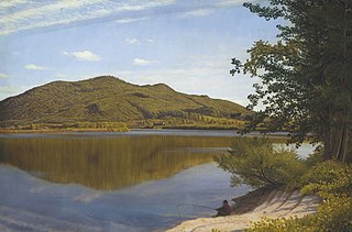
The Oxbow, also known as the Ox-Bow, is an extension of the Connecticut River, located in Northampton, Massachusetts. It is well-known for its appearance in the 1836 painting The Oxbow by Thomas Cole.
The Oxbow, also known as the Ox-Bow, is an extension of the Connecticut River, located in Northampton, Massachusetts. It is well-known for its appearance in the 1836 painting The Oxbow by Thomas Cole.
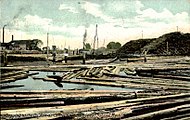
Historically, the Oxbow was connected directly to the Connecticut river as a large U-shaped bend. [1] In 1840, flood waters cut through the narrow section, separating the Oxbow from the main river and the current. In the early 1900s, the Oxbow was used extensively for logging operations, as a holding area for logs sent down river. The northern end was later cut off to build Interstate 91, which runs between the Oxbow and the Connecticut River. The Connecticut River is still accessible by a channel made under the Interstate 91 and U.S. Route 5 bridges. [2]
The Oxbow captured the imagination and attention of a broad set of artists over time. Thomas Cole described the scene as "well known" in 1836 [3] as he began his large painting of The Oxbow . A depiction of what was called "Hockanum Bend" had appeared in 1826 in "The northern traveller; containing the routes to Niagara, Quebec, and the Springs," by Theodore Dwight. In 1835 an illustration was created by W. H. Bartlett and published in the book "American Scenery" by George Virtue in 1837. By the second half of the 19th century the Oxbow was photographed for stereo-views and by the turn of the late 19th and early 20th century was featured in postcards and other memorabilia.
The Oxbow is habitat for many migratory and resident bird species. The Arcadia Wildlife Sanctuary (a project of Mass Audubon) protects a total of 776 acres (314 ha) [4] of land which forms the outer shore of the Oxbow. Among these species include bald eagle, snowy egret, cormorant, great blue heron, osprey, kingfisher, swifts, gulls, Canada geese, and ducks. [5]
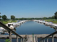
The Oxbow is used today primarily for pleasure boating, and is home to one of the largest marinas on the Connecticut River in Massachusetts. The Massachusetts Department of Conservation and Recreation operates a state boat ramp facility accessible from Route 5 in Easthampton, Massachusetts. Because it is partially separated from the main river body, boats are protected from strong current and floating debris. Other uses include flat water paddling and fishing. The Oxbow facilitates the Oxbow Water Ski Show Team, and used to be the home of Northampton Youth and Community Rowing, one of the larger scholastic and masters rowing clubs in western Massachusetts.


Mount Holyoke, a traprock mountain, elevation 935 feet (285 m), is the westernmost peak of the Holyoke Range and part of the 100-mile (160 km) Metacomet Ridge. The mountain is located in the Connecticut River Valley of western Massachusetts, and is the namesake of nearby Mount Holyoke College. The mountain is located in the towns of Hadley and South Hadley, Massachusetts. It is known for its historic summit house, auto road, scenic vistas, and biodiversity. The mountain is crossed by the 110-mile (180 km) Metacomet-Monadnock Trail and numerous shorter trails. Mount Holyoke is the home of J.A. Skinner State Park which is accessible from Route 47 in Hadley, Massachusetts.

The Pioneer Valley is the colloquial and promotional name for the portion of the Connecticut River Valley that is in Massachusetts in the United States. It is generally taken to comprise the three counties of Hampden, Hampshire, and Franklin. The lower Pioneer Valley corresponds to the Springfield, Massachusetts metropolitan area, the region's urban center, and the seat of Hampden County. The upper Pioneer Valley region includes the smaller cities of Northampton and Greenfield, the county seats of Hampshire and Franklin counties, respectively.

The Connecticut River is the longest river in the New England region of the United States, flowing roughly southward for 406 miles (653 km) through four states. It rises at the U.S. border with Quebec, Canada, and discharges at Long Island Sound. Its watershed encompasses 11,260 square miles (29,200 km2), covering parts of five U.S. states and one Canadian province, via 148 tributaries, 38 of which are major rivers. It produces 70% of Long Island Sound's fresh water, discharging at 18,400 cubic feet (520 m3) per second.
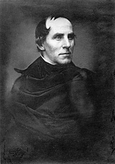
Thomas Cole was an Anglo-American painter known for his landscape and history paintings. One of the major 19th-century American painters, he is regarded as the founder of the Hudson River School, an American art movement that flourished in the mid-19th century. Cole's work is known for its romantic portrayal of the American wilderness.
An oxbow is part of oxen tack.

Elizur Holyoke of Springfield, Massachusetts was an English colonist, surveyor, scribe, soldier, the namesake of the mountain, Mount Holyoke, and indirectly, of the city of Holyoke, Massachusetts.

Mount Tom, 1,202 feet (366 m), is a steep, rugged traprock mountain peak on the west bank of the Connecticut River 4.5 miles (7 km) northwest of downtown Holyoke, Massachusetts. The mountain is the southernmost and highest peak of the Mount Tom Range and the highest traprock peak of the 100-mile (160 km) long Metacomet Ridge. A popular outdoor recreation resource, the mountain is known for its continuous line of cliffs and talus slopes visible from the south and west, its dramatic 1,100-foot (340 m) rise over the surrounding Connecticut River Valley, and its rare plant communities and microclimate ecosystems.

William Henry Bartlett was a British artist, best known for his numerous drawings rendered into steel engravings.

Joseph Allen Skinner State Park is a state-owned, public recreation area located in the towns of Hadley and South Hadley in the Connecticut River Valley of western Massachusetts. The state park surrounds Mount Holyoke, the westernmost peak of the Mount Holyoke Range. At the summit is the historic Prospect House, an old hotel first opened in 1851. The park is managed by the Massachusetts Department of Conservation and Recreation.
View from Mount Holyoke, Northampton, Massachusetts, after a Thunderstorm, commonly known as The Oxbow, is a seminal landscape painting by Thomas Cole, founder of the Hudson River School. The painting depicts a Romantic panorama of the Connecticut River Valley just after a thunderstorm. It has been interpreted as a confrontation between wilderness and civilization.
The South Hadley Canal was a canal along the Connecticut River in South Hadley, Massachusetts. It was the earliest navigable canal in the United States, with operation commencing in 1795. It has been listed on the National Register of Historic Places as the South Hadley Canal Historic District.

Connecticut River Greenway State Park is a protected environment with public recreation features that consists of separate state land holdings, including open spaces, parks, scenic vistas, and archaeological and historic sites, along the Connecticut River in the Pioneer Valley of western Massachusetts. The state park includes critical wildlife and plant habitat as well as areas providing public access to the river in its run across the state and is intertwined with other protected land including farmland under state-held agricultural preservation restrictions, municipal and conservation land trust holdings, and state and national wildlife refuges.
Route 47 is a 21.93-mile-long (35.29 km) north–south state highway in the Pioneer Valley region of the U.S. state of Massachusetts. Its southern terminus is at Route 116 in South Hadley and its northern terminus is at Route 63 in Montague.

Mount Nonotuck, 827 feet (252 m), is the northernmost peak of the Mount Tom Range of traprock mountains located in the Connecticut River Valley of Massachusetts and part of the larger Metacomet Ridge which stretches from Long Island Sound to nearly the Vermont border. Rugged and considered scenic, the peak rises steeply from the river valley 700 feet (210 m) below. It is located within the town of Holyoke.
The Mount Tom Range is a traprock mountain range located in the Connecticut River Valley of Massachusetts. It is part of the Metacomet Ridge that extends from Long Island Sound near New Haven, Connecticut, north through the Connecticut River Valley of Massachusetts to nearly the Vermont border. A popular outdoor recreation resource, the range is known for its continuous west facing cliffs and its rugged, scenic character. It is also notable for its unique microclimate ecosystems and rare plant communities, as well as significant historic sites, such as the ruins of the 18th century Eyrie House located on Mount Nonotuck.

The Holyoke Range or Mount Holyoke Range is a traprock mountain range located in the Connecticut River Valley of Massachusetts. It is a sub-range of the narrow, linear Metacomet Ridge that extends from Long Island Sound near New Haven, Connecticut north through the Connecticut River Valley of Massachusetts to the Vermont border. A popular hiking destination, the range is known for its anomalous east–west orientation, high ledges and its scenic character. It is also notable for its unique microclimate ecosystems and rare plant communities, as well as significant historic sites, such as the Mount Holyoke Summit House and the Horse Caves.
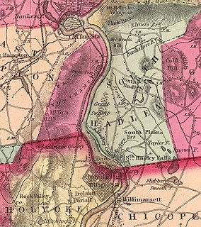
Hockanum Rural Historic District is a rural historic district along the Connecticut River in Hadley, Massachusetts. The district includes much of the area in Hadley west of Mount Holyoke and east of the river. Its formal boundaries run from Hockanum Cemetery in the southwest, following the river and the summit ridge of Mount Holyoke to the northeast corner of J.A. Skinner State Park. It includes the summit area of Mount Holyoke, including the Summit House, Halfway House, and other historic structures within the park, along with the agricultural lands of the valley below.

Dinosaur Footprints in Holyoke, Massachusetts, USA is an 8-acre (3 ha) wilderness reservation purchased for the public in 1935 by The Trustees of Reservations. The Reservation is currently being managed with the assistance from the Massachusetts Department of Conservation and Recreation (DCR). The fossil and plant resources on the adjacent Holyoke Gas and Electric (HG&E) riverfront property are being managed cooperatively by The Trustees, Mass DCR, and HG&E.

Smith's Ferry is a neighborhood in Holyoke, Massachusetts, United States, located to the north of the city center, approximately 1.5 miles (2.4 km) from downtown. The neighborhood prominently features the Mount Tom State Reservation, as well as the Mountain Park Amphitheater, the Dinosaur Footprints Reservation, and several other recreational and historic venues. Smith's Ferry is the second largest geographic division in Holyoke after Rock Valley, comprising roughly 3,800 acres (1,500 ha) of mixed residential, commercial, and recreational zoning.
Coordinates: 42°17′28″N72°37′45″W / 42.291025°N 72.629156°W