
Canaan was a Semitic-speaking civilization and region of the Southern Levant in the Ancient Near East during the late 2nd millennium BC. Canaan had significant geopolitical importance in the Late Bronze Age Amarna Period as the area where the spheres of interest of the Egyptian, Hittite, Mitanni, and Assyrian Empires converged or overlapped. Much of present-day knowledge about Canaan stems from archaeological excavation in this area at sites such as Tel Hazor, Tel Megiddo, En Esur, and Gezer.

Philistia was a confederation of five main cities or pentapolis in the Southwest Levant, made up of principally Gaza, Ashkelon, Ashdod, Ekron, and Gath, and for a time, Jaffa.
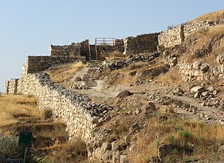
Lachish was an ancient Canaanite and Israelite city in the Shephelah region of Israel, on the south bank of the Lakhish River, mentioned several times in the Hebrew Bible. The current tell (ruin) by that name, known as Tel Lachish or Tell ed-Duweir, has been identified with the biblical Lachish. Today, it is an Israeli national park operated and maintained by the Israel Nature and Parks Authority. It lies near the present-day moshav of Lakhish.

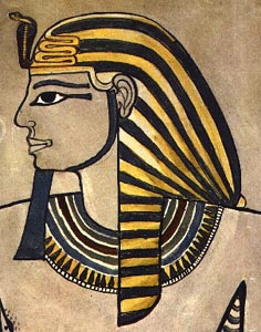
Thutmose III, sometimes called Thutmose the Great, was the sixth pharaoh of the 18th Dynasty. Officially he ruled Egypt from 28 April 1479 BC until 11 March 1425 BC, commencing with his coronation at the age of two and concluding with his death, aged fifty-six; however, during the first 22 years of his reign, he was coregent with his stepmother and aunt, Hatshepsut, who was named the pharaoh. While he was shown first on surviving monuments, both were assigned the usual royal names and insignia and neither is given any obvious seniority over the other. Thutmose served as the head of Hatshepsut's armies. During the final two years of his reign, he appointed his son and successor, Amenhotep II, as his junior co-regent. His firstborn son and heir to the throne, Amenemhat, predeceased Thutmose III.

Thutmose I was the third pharaoh of the 18th Dynasty of Egypt. He received the throne after the death of the previous king, Amenhotep I. During his reign, he campaigned deep into the Levant and Nubia, pushing the borders of Egypt farther than ever before in each region. He also built many temples in Egypt, and a tomb for himself in the Valley of the Kings; he is the first king confirmed to have done this.

Amenhotep I or Amenophis I, was the second Pharaoh of the 18th Dynasty of Egypt. His reign is generally dated from 1526 to 1506 BC.
Amenhotep II was the seventh pharaoh of the Eighteenth Dynasty of Egypt. He inherited a vast kingdom from his father Thutmose III, and held it by means of a few military campaigns in Syria; however, he fought much less than his father, and his reign saw the effective cessation of hostilities between Egypt and Mitanni, the major kingdoms vying for power in Syria. His reign is usually dated from 1427 to 1401 BC. His consort was Tiaa, who was barred from any prestige until Amenhotep's son, Thutmose IV, came into power.

The New Kingdom, also referred to as the Egyptian Empire, was the ancient Egyptian nation between the 16th century BC and the 11th century BC. This period of ancient Egyptian history covers the Eighteenth, Nineteenth, and Twentieth Dynasties. Through radiocarbon dating, the establishment of the New Kingdom has been placed between 1570 BC and 1544 BC. The New Kingdom followed the Second Intermediate Period and was succeeded by the Third Intermediate Period. It was the most prosperous time for the Egyptian people and marked the peak of Egypt's power.

Tel Megiddo, called in Arabic Tell el-Mutesellim, 'Mound of the Governor', is the site of the ancient city of Megiddo, the remains of which form a tell, situated in northern Israel near Kibbutz Megiddo, about 30 kilometres (19 mi) south-east of Haifa, at the western edge of the Jezreel Valley. Megiddo is known for its historical, geographical, and theological importance, especially under its Greek name Armageddon. During the Bronze Age, Megiddo was an important Canaanite city-state. During the Iron Age, it was a royal city in the Kingdom of Israel.

Gezer, or Tel Gezer, in Arabic: تل الجزر – Tell Jezar or Tell el-Jezari is an archaeological site in the foothills of the Judaean Mountains at the border of the Shfela region roughly midway between Jerusalem and Tel Aviv. It is now an Israeli national park. In the Hebrew Bible, Gezer is associated with Joshua and Solomon.
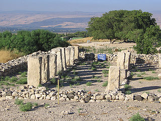
Tel Hazor, also Chatsôr, translated in LXX as Hasōr, named in Arabic Tell Waqqas / Tell Qedah el-Gul, is an archaeological tell at the site of ancient Hazor, located in Israel, Upper Galilee, north of the Sea of Galilee, in the northern Korazim Plateau. From the Middle Bronze Age to the Iron Age, Hazor was the largest fortified city in the region and one of the most important in the Fertile Crescent. It maintained commercial ties with Babylon and Syria, and imported large quantities of tin for the bronze industry. In the Book of Joshua, Hazor is described as "the head of all those kingdoms". Though scholars largely do not consider the Book of Joshua to be historically accurate, archaeological excavations have emphasized the city's importance.

The Shasu were Semitic-speaking pastoral nomads in the Southern Levant from the late Bronze Age to the Early Iron Age or the Third Intermediate Period of Egypt. They were tent dwellers, organized in clans ruled by a tribal chieftain and were described as brigands active from the Jezreel Valley to Ashkelon, in the Transjordan and in the Sinai. Some of them also worked as mercenaries for Asiatic and Egyptian armies.

The Mortuary Temple of Amenhotep III, also known as Kom el-Hettân, was built by the main architect Amenhotep, son of Hapu, for Pharaoh Amenhotep III during the 18th Dynasty of the New Kingdom. The mortuary temple is located on the Western bank of the Nile river, across from the eastern bank city of Luxor. During its time, the Mortuary Temple of Amenhotep III was the largest funerary complex in Thebes that was built. Only parts of the mortuary temple's layout remain, as well as the Colossi of Memnon, which are two large stone statues placed at the entrance measuring 18 meters high. Because the mortuary temple was built relatively close to the river, the annual flooding caused the site to decay at a more rapid rate. New research indicates that a large majority of the destruction on the mortuary temple can be attributed to the effects of an earthquake. It was long speculated that the earthquake occurred around 27 BC; however, investigations into the mortuary temple and surrounding colossi have debunked this time frame and instead have demonstrated it occurred around 1200 BC. Additional earthquakes after the one in 1200 BC have not been ruled out. The Colossi of Memnon and Amenhotep III Temple Project have helped conserve the site as well as possible.

The Late Bronze Age collapse was a time of widespread societal collapse during the 12th century BC associated with environmental change, mass migration, and the destruction of cities. The collapse affected a large area of the Eastern Mediterranean and the Near East, in particular Egypt, eastern Libya, the Balkans, the Aegean, Anatolia, and, to a lesser degree, the Caucasus. It was sudden, violent, and culturally disruptive for many Bronze Age civilizations, and it brought a sharp economic decline to regional powers, notably ushering in the Greek Dark Ages.

Retjenu, later known as Khor, was the Ancient Egyptian name for the wider Syrian region, where the Semitic-speaking Canaanites lived. Retjenu was located between the region north of the Sinai Desert and south of the Taurus Mountains in southern Anatolia. The term Retjenu was used to refer to this geographical area since the Middle Kingdom. The geographical area of Retjenu were defined during the New Kingdom and considered to have been a collection of small states ruled by princes. The boundaries of the area considered Retjenu shifted throughout time due to military, political, and economic factors. Retjenu was divided into two geographical regions. Djahy the southernmost region covered the area between Askalon and Mount Lebanon stretching inland to the Sea of Galilee. Amurru the northern region stretched between the Lebanon and Taurus Mountains. During Thutmose III's military campaigns in West Asia the area of Djahy was referred to as Upper Retjenu and generally covered the area of Canaan. Lower Retjenu was used to refer to the area of Amurru but also incorporated the cities located along Phoenician coast.

Scarabs are beetle-shaped amulets and impression seals which were widely popular throughout ancient Egypt. They still survive in large numbers today, and are popular among collectors of ancient artifacts. Through their inscriptions and typology, they prove to be an important source of information for archaeologists and historians of the ancient world, and represent a significant body of ancient Egyptian art.

Djehuty was a general under the ancient Egyptian king Thutmose III in the 18th Dynasty. He is known as the main hero of the tale of "The Taking of Joppa". Djehuty bears the titles king's scribe, overseer of troops (general) and overseer of the northern foreign countries in contemporary Egyptian records.
The Eighteenth Dynasty of Egypt is classified as the first dynasty of the New Kingdom of Egypt, the era in which ancient Egypt achieved the peak of its power. The Eighteenth Dynasty spanned the period from 1550/1549 to 1292 BC. This dynasty is also known as the Thutmoside Dynasty) for the four pharaohs named Thutmose.
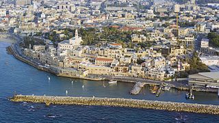
Jaffa, also called Japho or Joppa in English, is an ancient Levantine port city founded by the Canaanites that is now part of southern Tel Aviv, Israel. Sitting atop a naturally elevated outcrop on the Mediterranean coastline, it was a strategic location that exchanged hands repeatedly in ancient Near East history, and was also contested during the Crusades, when it presided over the County of Jaffa and Ascalon.
The temple of Thutmose III at Deir el-Bahari is a temple in the central part of the Deir el-Bahari Valley, built on a rocky platform and thus dominating over the earlier structures: the temple of Hatshepsut and the temple of Mentuhotep Nebhepetre of the Eleventh Dynasty. The temple was built in the last decade of Thutmose III’s rule, i.e., about 1435–1425 BC. It was destroyed, probably by an earthquake, at the beginning of the Twenty-first Dynasty. Fragments of walls covered with relief decoration were preserved. The building was presumably built on the neighboring terraced temples with pillared porticoes flanking the ramps leading to higher levels. It was called Djeser-akhet. The remains of the temple of Thutmose III were uncovered in the years 1962–67. The excavations were initiated by Prof. Kazimierz Michałowski, then director of the Polish Centre of Mediterranean Archaeology of the University of Warsaw in Cairo. Work was resumed in 1978 to reconstruct the decoration of the temple.