Thompson, New York

Last updated

Thompson, New York
Thompson, NY, town hall.jpg
Town hall on Route 42, 2013
Sullivan County New York incorporated and unincorporated areas Thompson highlighted.svg
Location of Thompson in Sullivan County, New York
Coordinates: 41°38′58″N74°40′21″W / 41.64944°N 74.67250°W / 41.64944; -74.67250
Country United States
State New York
County Sullivan
Area
[1]
  Total87.50 sq mi (226.62 km2)
  Land84.09 sq mi (217.79 km2)
  Water3.41 sq mi (8.83 km2)
Elevation
1,476 ft (450 m)
Population
 (2020)
  Total16,550
  Density190/sq mi (73/km2)
Time zone UTC-5 (Eastern (EST))
  Summer (DST) UTC-4 (EDT)
FIPS code 36-73627
GNIS feature ID0979543

Thompson is a town in the southern part of Sullivan County, New York, United States. The population was 16,550 at the 2020 census. [2] The town is named after William Thompson, an early settler.

Contents

History

The town was first settled in 1749. Thompson was established in 1803 from the town of Mamakating. Part of the town was taken from the town of Fallsburg in 1826.

Geography

According to the United States Census Bureau, the town has a total area of 87.4 square miles (226 km2), of which 84.1 square miles (218 km2) is land and 3.3 square miles (8.5 km2) (3.77%) is water.

Demographics

Historical population
CensusPop.Note
1820 1,897
1830 2,45929.6%
1840 2,6106.1%
1850 3,19822.5%
1860 3,83419.9%
1870 3,514−8.3%
1880 3,7637.1%
1890 3,462−8.0%
1900 3,7398.0%
1910 4,19612.2%
1920 4,5979.6%
1930 5,95029.4%
1940 6,0541.7%
1950 6,91214.2%
1960 8,79227.2%
1970 11,41829.9%
1980 13,55018.7%
1990 13,7111.2%
2000 14,1893.5%
2010 15,3087.9%
2020 16,5508.1%
U.S. Decennial Census [3] 2020 [4]

As of the census [5] of 2000, there were 14,189 people, 5,543 households, and 3,481 families residing in the town. The population density was 168.7 inhabitants per square mile (65.1/km2). There were 9,258 housing units at an average density of 110.1 per square mile (42.5/km2). The racial makeup of the town was 73.70% white, 16.94% African American, 0.18% Native American, 1.85% Asian, 0.03% Pacific Islander, 4.64% from other races, and 2.67% from two or more races. Hispanic or Latino of any race were 14.56% of the population.

There were 5,543 households, out of which 30.0% had children under the age of 18 living with them, 42.4% were married couples living together, 15.2% had a female householder with no husband present, and 37.2% were non-families. 30.6% of all households were made up of individuals, and 11.3% had someone living alone who was 65 years of age or older. The average household size was 2.44 and the average family size was 3.04.

In the town, the population was spread out, with 26.0% under the age of 18, 7.4% from 18 to 24, 26.8% from 25 to 44, 25.5% from 45 to 64, and 14.2% who were 65 years of age or older. The median age was 38 years. For every 100 females, there were 97.0 males. For every 100 females age 18 and over, there were 94.0 males.

The median income for a household in the town was $35,511, and the median income for a family was $41,043. Males had a median income of $37,759 versus $26,692 for females. The per capita income for the town was $18,668. About 18.3% of families and 23.3% of the population were below the poverty line, including 34.9% of those under age 18 and 13.4% of those age 65 or over.

Communities and locations in the town of Thompson

Related Research Articles

<span class="mw-page-title-main">Sullivan County, New York</span> County in New York, United States

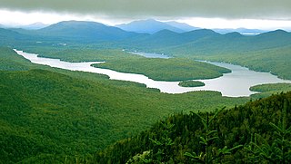
Sullivan County is a county in the U.S. state of New York. As of the 2020 census, the population was 78,624. The county seat is Monticello. The county's name honors Major General John Sullivan, who was labeled at the time as a hero in the American Revolutionary War in part due to his successful campaign against the Iroquois. The county is part of the Hudson Valley region of the state.

<span class="mw-page-title-main">North Elba, New York</span> Town in New York, United States

North Elba is a town in Essex County, New York, United States. The population was 7,480 at the 2020 census.

<span class="mw-page-title-main">Harrietstown, New York</span> Town in New York, United States

Harrietstown is a town in Franklin County, New York, United States. The total population was 5,254 at the 2020 census, In 2010 3,879 of the town's residents lived in the village of Saranac Lake on the eastern side of the town.

<span class="mw-page-title-main">Richfield, New York</span> Town in Otsego County, New York, US

Richfield is a town located in Otsego County, New York, United States. As of the 2010 census, the town had a population of 2,388. The Town of Richfield is located at the northern border of the county.

<span class="mw-page-title-main">Northumberland, New York</span> Town in New York, United States

Northumberland is a town in Saratoga County, New York, United States. Immediately north of Schuylerville and northeast of Saratoga Springs the town is also located on the west bank of the Hudson River.

Dix is a town in Schuyler County, New York, United States. The population was 3,723 at the 2020 census.

Urbana is a town in Steuben County, New York, United States. The population was 2,125 at the 2020 census.

<span class="mw-page-title-main">Fallsburg, New York</span> Town in New York, United States

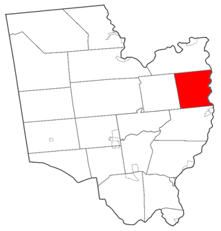
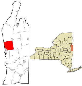
Fallsburg is a town in Sullivan County, New York, United States. The town is in the eastern part of the county. The population was 14,192 at the 2020 census. It is not to be confused with the hamlet of Fallsburg which bears a similar name and is within the town of Fallsburg.

<span class="mw-page-title-main">Fremont, Sullivan County, New York</span> Town in New York, United States

Fremont is a town in Sullivan County, New York, United States. The population was 1,161 at the 2020 census.

<span class="mw-page-title-main">Lumberland, New York</span> Town in New York, United States

Lumberland is a town in Sullivan County, New York, United States. The population was 2,243 at the 2020 census.

<span class="mw-page-title-main">Monticello, New York</span> Village in Sullivan County, New York

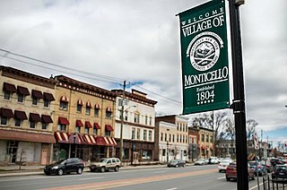
Monticello is a village located in Thompson, Sullivan County, within the Catskills region of New York, United States. It is the seat for the town of Thompson, and the county seat of Sullivan County. The population was 7,173 at the 2020 census. The village was named after the residence of Thomas Jefferson.

<span class="mw-page-title-main">Marlborough, New York</span> Town in New York, United States

Marlborough is a town in Ulster County, New York, United States, in the southeastern corner of the county. The population was 8,712 at the 2020 census. U.S. Route 9W passes through the eastern part of the town. US Route 44 and NY 55 cross the northwestern corner of the town. The town was named after the Duke of Marlborough.

<span class="mw-page-title-main">Wawarsing, New York</span> Town in New York, United States

Wawarsing is a town in Ulster County, New York, United States. The population was 12,771 at the 2020 census. The name Wawarsing was once believed to mean "a place where the streams wind" in the Lenape language, referring to the geography in the hamlet of Wawarsing. Specifically, the joining of the Ver Nooy Kill and the Rondout Creek at Port Ben. The name Wawarsing was used by the Lenape to designate the current hamlet and the fields to the north and south of it for at least six miles in both directions. It is the only Lenape name known to refer to an exact location in Ulster County.

<span class="mw-page-title-main">Chester, Warren County, New York</span> Town in New York, United States

Chester is a town in Warren County, New York, United States. It is part of the Glens Falls metropolitan area. The population was 3,086 at the 2020 census. The town is made up by communities of Chestertown and Pottersville.

<span class="mw-page-title-main">Queensbury, New York</span> Town in New York, United States

Queensbury is a town in Warren County, New York, United States. The population was 29,169 at the 2020 census.

<span class="mw-page-title-main">Kingsbury, New York</span> Hamlet in the state of New York, United States

Kingsbury is a town in western Washington County, New York, United States. It is part of the Glens Falls Metropolitan Statistical Area. The town population was 12,968 at the 2020 census, up from 12,671 at the 2010 census.

<span class="mw-page-title-main">Moravia, New York</span> Town in New York, United States

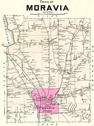
Moravia is a town in Cayuga County, New York. The population was 3,626 at the time of the 2010 census.

<span class="mw-page-title-main">Herkimer, New York</span> Town in New York, United States

Herkimer is a town in Herkimer County, New York, United States, southeast of Utica. It is named after Nicholas Herkimer. The population was 9,566 at the 2020 census, down from 10,175 in 2010.

<span class="mw-page-title-main">Gouverneur, New York</span> Town in New York, United States

Gouverneur is a town in St. Lawrence County, New York, United States. As of the 2020 census, the population was 6,551. That was down from 7,085 in 2010. The town is named after statesman and landowner Gouverneur Morris.

<span class="mw-page-title-main">Liberty, New York</span> Town in New York, United States

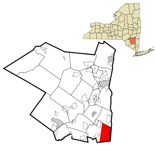
Liberty is a town in Sullivan County, New York, United States. The population was 10,159 at the 2020 census. The village is bisected by New York State Route 52 (NY 52) and NY 55, and is crossed by NY 17.

References

  1. "2016 U.S. Gazetteer Files". United States Census Bureau. Retrieved July 5, 2017.
  2. US Census Bureau, 2020 Census Report Thompson, Sullivan County, New York QuickFacts https://www.census.gov/quickfacts/thompsontownsullivancountynewyork
  3. "Census of Population and Housing". Census.gov. Retrieved June 4, 2015.
  4. US Census Bureau, 2020 Census Report Thompson, Sullivan County, New York QuickFacts https://www.census.gov/quickfacts/thompsontownsullivancountynewyork
  5. "U.S. Census website". United States Census Bureau . Retrieved January 31, 2008.
  6. "National Register Information System". National Register of Historic Places . National Park Service. March 13, 2009.

41°38′11″N74°40′21″W / 41.63639°N 74.67250°W / 41.63639; -74.67250