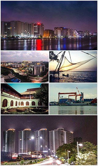
Kochi, also known by its former name Cochin, is a major port city along the Malabar Coast of India bordering the Laccadive Sea. It is part of the district of Ernakulam in the state of Kerala. The city is also commonly referred to as Ernakulam. As of 2011, the Kochi Municipal Corporation had a population of 677,381 within an area of 94.88 km2, and the larger Kochi urban agglomeration had a total population of more than of 2.1 million within an area of 440 km2, making it the largest and the most populous metropolitan area in Kerala. Kochi city is also part of the Greater Cochin development region and is classified as a Tier-II city by the Government of India. The civic body that governs the city is the Kochi Municipal Corporation, which was constituted in the year 1967, and the statutory bodies that oversee its development are the Greater Cochin Development Authority (GCDA) and the Goshree Islands Development Authority (GIDA).

Ernakulam, IPA: [erɐɳɐːguɭɐm]; ISO: Eṟaṇākuḷaṁ, in Malayalam: എറണാകുളം), is one of the 14 districts in the Indian state of Kerala, that takes its name from the eponymous city division in Kochi. It is situated in the central part of the state, spans an area of about 3,000 square kilometres (1,200 sq mi), and is home to over 9% of Kerala's population. Its headquarters are located at Kakkanad. The district includes Kochi, also known as the commercial capital of Kerala, which is famous for its ancient Churches, Hindu temples, synagogues and mosques. The district includes the largest metropolitan region of the state: Greater Cochin. Ernakulam is the district that yields the most revenue and the largest number of industries in the state. Ernakulam is the third most populous district in Kerala, after Malappuram and Thiruvananthapuram. The district also hosts the highest number of international and domestic tourists in Kerala state.
Willingdon Island is the largest artificial island in India, which forms part of the city of Kochi, in the state of Kerala. Much of the present Willingdon Island was claimed from the Lake of Kochi, filling in dredged soil around a previously existing, but tiny, natural island. Willingdon Island is significant as the home for the Port of Kochi as well as the Kochi Naval Base, the Southern Naval Command of the Indian Navy, Plant Quarantine station, Custom House Cochin and Central Institute of Fisheries Technology, a constituent unit of Indian Council of Agricultural Research.
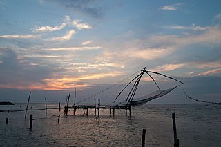
Fort Kochi, Fort Cochin in English, Cochim de Baixo in Cochin Portuguese creole, is a neighbourhood of Cochin (Kochi) city in Kerala, India. Fort Kochi takes its name from the Fort Manuel of Cochin, the first European fort on Indian soil, controlled by the Portuguese East Indies. This is part of a handful of water-bound islands and islets toward the south-west of the mainland Kochi, and collectively known as Old Cochin or West Cochin. Adjacent to this is the locality of Mattancherry. In 1967, these three municipalities along with a few adjoining areas, were amalgamated to form the Kochi Municipal Corporation.

Ernakulam is the central business district of the city of Kochi, Kerala, India. It is the namesake of Ernakulam district. Many major establishments, including the Kerala High Court, the office of the Kochi Municipal Corporation and the Cochin Shipyard are situated here.

Cochin Port or Kochi Port is a major port on the Arabian Sea – Laccadive Sea – Indian Ocean sea-route in the city of Kochi and is one of the largest ports in India. It is also the first transshipment port in India. The port lies on two islands in the Lake of Kochi: Willingdon Island and Vallarpadam, towards the Fort Kochi river mouth opening onto the Laccadive Sea. The International Container Transshipment Terminal (ICTT), part of the Cochin Port, is the largest container transshipment facility in India.

Greater Cochin Development Authority (GCDA) is the statutory body overseeing the development of the city of Kochi in the state of Kerala, India. Headquartered at Kadavanthra, GCDA oversees the development of the major part of Greater Cochin area which consists of the Kochi Municipal Corporation, surrounding municipalities and 21 intervening panchayats covering an area of 632 km2.
Sir Robert Bristow was a British harbour engineer best known for his contributions to the development of the port of Kochi (Cochin) in Kerala, India and is regarded as the architect of modern Kochi port. Bristow recounted his experiences in his book Cochin Saga, which is considered an important source of historiography of Kerala. He is also noted for his initiatives in founding the Lotus Club, the first inter-racial club in Kochi. He was also a member of the Royal Society of Arts.

Kochi is a city in the Indian state of Kerala. Kochi is located in the district of Ernakulam. Old Kochi loosely refers to a group of islands including Willingdon Island, Fort Kochi, Mattancherry and Mundamveli. Today, Kochi includes Ernakulam, old parts of Kochi, Kumbalangi, and outlying islands. For many centuries up to and during the British Raj, the city of Kochi was the seat of the eponymous princely state — the Kingdom of Cochin, which lay between 9.48° and 10.50° latitude and 76.5° and 76.58° E longitude.
Kochi is a major port city in the Indian state of Kerala. The city is widely known as the commercial or economic capital of the state of Kerala.

Mattancherry BOT Bridge, also known as Thoppumpady Bridge is a bridge in Kochi, Kerala, India. It connects the Kochi's western mainland to Willingdon Island. The new bridge was constructed in 1998; succeeding the old bridge of the same name, which is now known as the Old Cochin Harbour Bridge, built in 1940. The old bridge, which is a landmark of Kochi is now preserved as a heritage monument and carries only two and three wheelers.
Nettoor is a region in the city of Kochi. It is around 5 km (3.1 mi) from Vytilla Junction and around 8 km (5.0 mi) from Ernakulam Junction Railway Station. Nettoor is located on Panangad Island and is a part of Maradu Municipality.

Cochin Harbour Terminus (CHTS) is one of the railway stations in the city of Kochi, in the state of Kerala, India. It is located on the Willingdon Island. During the peak time of the station, 17 trains operated from here to different parts of the country and served as the principal station providing rail connectivity to the southern segment of the Port of Kochi located on the Willingdon Island. The station, which has not been in use after the commissioning of Vallarpadam container terminus is now locked and all the train service to the station from Ernakulam Junction were completely stopped in 2013. Since then, only occasional tourist trains carrying passengers will arrive at the station – notably the Golden Chariot in 2022.
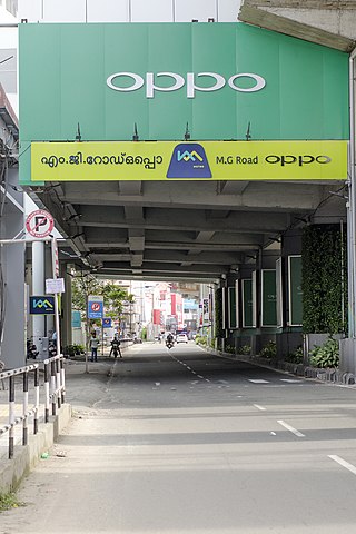
Mahatma Gandhi Road, popularly known as M. G. Road, is the main artery as well as the commercial high street of the city of Kochi, in the state of Kerala, India. The road lies north-south with its boundaries at the Venduruthy bridge, Thevara in the south, and the Madhava Pharmacy Junction in the north, where it intersects the Banerji Road. The road was earlier part of the NH 47A and was later handed over to Kochi Municipal Corporation. The highway was earlier known as Seventy Feet road. The total distance of the road is 4.5 kilometres (2.8 mi).
This is a list of areas and neighbourhoods in Cochin by region.
Edakochi is a ward of Kochi, Kerala. Located in the southern portion of the Fort Kochi peninsula, it borders Palluruthy to the northwest and is separated from Aroor to the south and Kumbalam to the east by the Kerala backwaters. It is adjacent to the Kumbalangi tourism village that connects through Perumpadappu.
Transport in Ernakulam district consists of various modes.
Venduruthy-Vikrant Bridge, also known as Venduruthy Bridge is a bridge in Kochi, Kerala, India. There are two bridges at present; one railway bridge and one road bridge, running parallel to each other, that connects the Ernakulam side of Kochi to the Willingdon Island. The old Venduruthy railway bridge was constructed in 1938 along with two parallel road bridges. The old railway bridge is one of the first bridges in India to be completely constructed from steel. It is a landmark in Kochi with historic significance as it played a major role in the transformation of Kochi into a major port city in India during the British era.


