Thorney Close

Last updated

Thorney Close
Thorney Close, Sunderland.jpg
Thorndale Road, Thorney Close
Tyne and Wear UK location map.svg
Red pog.svg
Thorney Close
Location within Tyne and Wear
Population11,125 
Metropolitan borough
Metropolitan county
Region
Country England
Sovereign state United Kingdom
Post town SUNDERLAND
Postcode district SR3 4
Police Northumbria
Fire Tyne and Wear
Ambulance North East
UK Parliament
List of places
UK
England
Tyne and Wear
54°52′58″N1°25′54″W / 54.8828°N 1.4316°W / 54.8828; -1.4316

Thorney Close is a suburb of Sunderland, Tyne and Wear in England.

Contents

It is located on the northern edge of the A690 (Durham Road), and borders with Grindon to the north and Herrington to the south, and the A19 to the west. Originally emerging as a Tudor era manor estate and orchard, Thorney Close was purchased by Sunderland authorities in the late 1940s and transformed into one of first its post-war housing states.

History

Middle Ages and Tudor Period

The specific origins of the Thorney Close estate and its name remain unclear. During the Middle Ages, the land was speculated to either be part of the neighbouring Farringdon Hall estate, or is speculated by historians to be part of the former "Clowcroft" estate of which the precise location remains unknown. However, by the Tudor era the name "Thornye Close" appears in historical record, having been owned by three times Mayor of Newcastle Upon Tyne Richard Hodgson and willed to his son Robert. [1] This coincides with reports of the former manor, "Thorney Close Hall" being built in the Tudor Period around 1546, of which was part of the township of Silksworth under the parish of Bishopwearmouth. [2] [3]

The Modern Estate

In 1947, land around the manor was acquired by the Sunderland corporation who began to transform the area into a post-war social housing estate. By 1948 the first 77 homes had been built, ushering in the demolition of the historic manor which following the death of its last owner Violet Bulkley, had been made redundant. By 1971 the population had risen to just under 14,000. [4] According to the 2001 Census, the population was 9,938, with 36.7% living in council houses. [5] In the 2011 Census the population was 11,125, as reported as part of the Sandhill ward. [6]

The estate has three shopping arcades, a community centre, one working men's club, a recently built residential home for the elderly, three Methodist churches, and two primary schools, and a secondary school which was rebuilt in 2003. The former secondary school site is host to the new school, community centre, the local branch library, which was moved from Grindon and a walk in health centre.

Most of the streets in Thorney Close begin with the letter "T". Such as, Telford Road, Twickenham Road, Torquay Road, Thorney Close Road, Taunton Square and Tadcaster Road.

Deprivation

According to the Office of National Statistics Census 2021",Thorney Close ranks joint 2nd with Plains Farm for deprivation within Sunderland at 68.9%, falling from 74.7% in 2011. Hendon and docks ranked 1st at 69% of households being deprived.

The estate was the feature location of a short-horror story "The Curse of Thorney Close" which embedded themes of poverty, crime and desperation into a tale of witchcraft in the area. [7] [8]

Related Research Articles

<span class="mw-page-title-main">Washington, Tyne and Wear</span> Town in England

Washington is a town in the City of Sunderland district of Tyne and Wear, England. Historically part of County Durham, it is the ancestral settlement of the Washington family, which George Washington descended from.

<span class="mw-page-title-main">Sunderland</span> City in Tyne and Wear, England

Sunderland is a port city in Tyne and Wear, England. It is the City of Sunderland's administrative centre and in the historic county of Durham. The city is 10 miles (16 km) from Newcastle-upon-Tyne and is on the River Wear's mouth to the North Sea. The river also flows through Durham roughly 12 miles (19 km) south-west of Sunderland City Centre. It is the only other city in the county and the second largest settlement in the North East after Newcastle upon Tyne.

<span class="mw-page-title-main">Metropolitan Borough of Gateshead</span> Metropolitan borough in Tyne and Wear, England

The Metropolitan Borough of Gateshead is a metropolitan borough in the metropolitan county of Tyne and Wear, North East England. It includes Gateshead, Rowlands Gill, Whickham, Blaydon, Ryton, Felling, Birtley, Pelaw, Dunston and Low Fell. The borough forms part of the Tyneside conurbation, centred on Newcastle upon Tyne.

<span class="mw-page-title-main">Felling, Tyne and Wear</span> Human settlement in England

Felling is a town in the Metropolitan Borough of Gateshead in Tyne and Wear, England. Historically part of County Durham, the town became part of the metropolitan borough of Gateshead in 1974. It lies on the B1426 Sunderland Road and the A184 Felling bypass, than 1 mile (1.6 km) east of Gateshead, 1 mile (1.6 km) south east of Newcastle-upon-Tyne and 10 miles north west of the City of Sunderland. In 2011, Felling had a population of 8,908.

Gilesgate is a place in County Durham, England. It is situated east of the centre of Durham. It is also a ward of Durham with a total population taken at the 2011 census was 8,074.

<span class="mw-page-title-main">Sunderland South (UK Parliament constituency)</span> Parliamentary constituency in the United Kingdom, 1950–2010

<span class="mw-page-title-main">Dunston, Tyne and Wear</span> Area of Gateshead, Tyne and Wear, England

Dunston is a western area of the town of Gateshead on the south bank of the River Tyne, in the Metropolitan Borough of Gateshead, North East England. Dunston had a population of 18,326 at the 2011 Census.

<span class="mw-page-title-main">Deckham</span> Human settlement in England

Deckham is a residential suburb in the Metropolitan Borough of Gateshead in Tyne and Wear, England. It is bordered by Gateshead town centre to the north, Sheriff Hill to the south, Felling and Carr Hill to the east and Shipcote to the west. It lies on the B1296, the route of the old Great North Road, 1 mile (1.6 km) south of Gateshead town centre, 1.5 miles (2.4 km) south of Newcastle-upon-Tyne and 13 miles (21 km) north of the city of Durham. In 2011, Deckham had a population of 9,938.

<span class="mw-page-title-main">Farringdon, Sunderland</span> Suburb in Tyne and Wear, England

Farringdon is a suburb of Sunderland, Tyne and Wear, England. Originally a Monastic grange and manor estate for hundreds of years, Farringdon was rebuilt as a post-war council housing estate in the 1950s. It is approximately 3 mi (4.8 km) south of the city centre along the A690, close to Thorney Close, Silksworth, East Herrington, Gilley Law and Doxford Park. Electorally, the area comes under the St. Chad's ward of the City.

<span class="mw-page-title-main">Grindon, Sunderland</span> Human settlement in England

Grindon is a suburb of Sunderland, Tyne and Wear, England.

<span class="mw-page-title-main">Sunderland City Council</span> Local authority of Sunderland, England

Sunderland City Council is the local authority of the City of Sunderland in Tyne and Wear, England. It is a metropolitan district council, one of five in Tyne and Wear and one of 36 in the metropolitan counties of England, and provides the majority of local government services in Sunderland.

<span class="mw-page-title-main">Fence Houses</span> Village in Tyne and Wear, England

Fence Houses, or Fencehouses is a village in the City of Sunderland in Tyne and Wear, England.

<span class="mw-page-title-main">Springwell Village</span> Human settlement in England

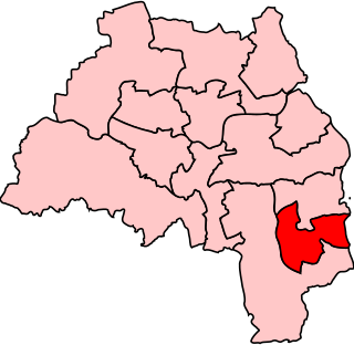
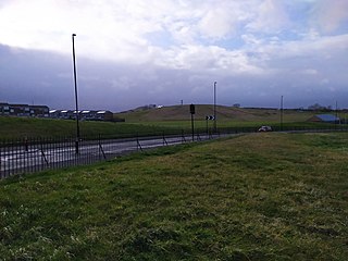
Springwell Village is a village in the City of Sunderland, bordering Gateshead, approximately 7.6 miles (12.2 km) from Newcastle upon Tyne, 9 miles (14 km) from Sunderland, and 13 miles (21 km) from Durham. In 2011, Census data for the City of Sunderland ward of Washington West recorded a total population of 11,833.

Sandhill View Academy is a coeducational secondary school in Sunderland, Tyne and Wear, England.

Plains Farm is a suburb of Sunderland, Tyne and Wear, England, and is a council-built housing estate, erected in the 1940s. Neighbouring areas include Silksworth, The Barnes, Thorney Close, Springwell and Farringdon. The housing in the area is run predominantly by Home Group and Gentoo Sunderland. Many houses are rented via the two companies; others have been purchased by home owners. The majority of housing is either Terraced or Semi Detached.

Seaburn Dene is a northern suburb of Sunderland, England, located about one mile inland from the North Sea, near the boundary with South Tyneside.

<span class="mw-page-title-main">Sunderland Corporation Tramways</span>

Sunderland Corporation Tramways operated a tramway service in Sunderland between 1900 and 1954.

References

  1. Greenwell, William (1860). Publications of the Surtees Society, Volume 38. Durham: Blackwood and Sons. p. 116. ISBN   9780198702955.
  2. "It's 1952 in Reteo". Sunderland Echo. Retrieved 7 September 2020.
  3. "Threatened by Housing Plan". Sunderland Echo. British Newspaper Archive. Retrieved 8 March 2022.
  4. "Diamond date for Thorney Close". Sunderland Echo. Archived from the original on 7 January 2007. Retrieved 16 January 2007.
  5. "Thorney Close 2001 Census Ward Card" (PDF). Sunderland City Council. Archived from the original (PDF) on 27 September 2007. Retrieved 16 January 2007.
  6. UK Census (2011). "Local Area Report – Sandhill Ward (as of 2011) (E05001169)". Nomis. Office for National Statistics . Retrieved 3 October 2019.
  7. Phantasmal Horror Stories: The Curse of Thorney Close
  8. Sunderland's First Horror Story: The Curse of Thorney Close