Thornton, Texas

Last updated

Thornton, Texas
Masonic Thornton Wiki (1 of 1).jpg
Masonic building in Thornton, Texas
TXMap-doton-Thornton.PNG
Location of Thornton, Texas
Limestone County Thornton.svg
Coordinates: 31°24′36″N96°34′25″W / 31.41000°N 96.57361°W / 31.41000; -96.57361
Country United States
State Texas
County Limestone
Area
[1]
  Total0.99 sq mi (2.55 km2)
  Land0.98 sq mi (2.54 km2)
  Water0.01 sq mi (0.01 km2)
Elevation
492 ft (150 m)
Population
 (2010) [2]
  Total526
  Estimate 
(2019) [3]
524
  Density536.0/sq mi (206.96/km2)
Time zone UTC-6 (Central (CST))
  Summer (DST) UTC-5 (CDT)
ZIP code
76687
Area code 254
FIPS code 48-72788 [4]
GNIS feature ID1369866 [5]
Website cityofthorntontx.com

Thornton is a town in Limestone County, Texas, United States. The population was 526 at the 2010 census. [2]

Contents

Geography

Thornton is located at 31°24′36″N96°34′25″W / 31.41000°N 96.57361°W / 31.41000; -96.57361 (31.409906, –96.573594). [6]

According to the United States Census Bureau, the town has a total area of 1.0 square mile (2.6 km2), of which 1.0 square mile (2.6 km2) is land and 1.00% is water.

Climate

The climate in this area is characterized by hot, humid summers and generally mild to cool winters. According to the Köppen Climate Classification system, Thornton has a humid subtropical climate, abbreviated "Cfa" on climate maps. [7]

Demographics

Historical population
CensusPop.Note
1880 182
1890 466156.0%
1910 678
1920 7338.1%
1930 7390.8%
1940 7450.8%
1950 623−16.4%
1960 504−19.1%
1970 433−14.1%
1980 49815.0%
1990 5408.4%
2000 525−2.8%
2010 5260.2%
2019 (est.)524 [3] −0.4%
U.S. Decennial Census [8]

As of the census [4] of 2000, there were 525 people, 206 households, and 147 families residing in the town. The population density was 529.5 inhabitants per square mile (204.4/km2). There were 248 housing units at an average density of 250.1 per square mile (96.6/km2). The racial makeup of the town was 88.00% White, 6.48% African American, 0.95% Native American, 0.19% Asian, 2.86% from other races, and 1.52% from two or more races. Hispanic or Latino of any race were 8.00% of the population.

There were 206 households, out of which 32.0% had children under the age of 18 living with them, 55.8% were married couples living together, 8.7% had a female householder with no husband present, and 28.6% were non-families. 23.8% of all households were made up of individuals, and 13.1% had someone living alone who was 65 years of age or older. The average household size was 2.55 and the average family size was 3.04.

In the town, the population was spread out, with 28.2% under the age of 18, 5.5% from 18 to 24, 28.8% from 25 to 44, 21.9% from 45 to 64, and 15.6% who were 65 years of age or older. The median age was 37 years. For every 100 females, there were 98.1 males. For every 100 females age 18 and over, there were 96.4 males.

The median income for a household in the town was $26,607, and the median income for a family was $31,538. Males had a median income of $24,792 versus $20,000 for females. The per capita income for the town was $12,615. About 13.7% of families and 16.4% of the population were below the poverty line, including 15.5% of those under age 18 and 11.1% of those age 65 or over.

Education

Thornton is served by the Groesbeck Independent School District.

Related Research Articles

<span class="mw-page-title-main">Thornton, Arkansas</span> City in Arkansas, United States

Thornton is a city in Calhoun County, Arkansas, United States. The population was 407 as of the 2010 census, down from 517 in 2000. It is part of the Camden, Arkansas micropolitan area.

<span class="mw-page-title-main">Beverly Beach, Florida</span> Town in Florida, United States

Beverly Beach is a town in Flagler County, Florida, United States. The Town of Beverly Beach is part of the Deltona–Daytona Beach–Ormond Beach, FL metropolitan statistical area. The population was 474 at the 2020 census, up from 338 in the 2010 census.

<span class="mw-page-title-main">Thornton, Illinois</span> Village in Illinois, United States

Thornton is a village in Cook County, Illinois, United States and a south suburb of Chicago. The population was 2,386 at the 2020 census. Thornton is home to the Thornton Quarry, one of the largest quarries in the world.

<span class="mw-page-title-main">Randolph, Kansas</span> City in Riley County, Kansas

Randolph is a city in Riley County, Kansas, United States. As of the 2020 census, the population of the city was 159.

<span class="mw-page-title-main">Lavina, Montana</span> Town in Montana, United States

Lavina is a town in Golden Valley County, Montana, United States. The population was 136 at the 2020 census. The town is situated on the north bank of the Musselshell River.

<span class="mw-page-title-main">Nashua, Montana</span> Town in Montana, United States

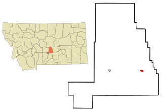
Nashua is a town in Valley County, Montana, United States. The population was 301 at the 2020 census.

<span class="mw-page-title-main">Oak Ridge, Kaufman County, Texas</span> Town in Texas, United States

Oak Ridge is a town in Kaufman County, Texas, United States. The population was 495 at the 2010 census, up from 400 at the 2000 census.

<span class="mw-page-title-main">Dawson, Texas</span> Town in Texas, United States

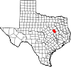
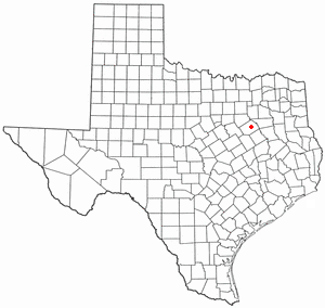
Dawson is a town in Navarro County, in the U.S. state of Texas. The population was 807 at the 2010 census.

<span class="mw-page-title-main">Kerens, Texas</span> City in Texas, United States

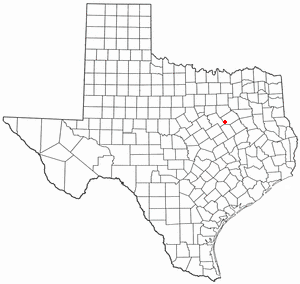
Kerens is a city in Navarro County, Texas, United States. The population was 1,573 at the 2010 census.

<span class="mw-page-title-main">Powell, Texas</span> Town in Texas, United States

Powell is a town in Navarro County, Texas, United States. The population was 136 at the 2010 census.

<span class="mw-page-title-main">Clinchco, Virginia</span> Town in Virginia, United States

Clinchco is a town in Dickenson County, Virginia, United States. The town, formerly known as Moss, was named for both the Clinchfield Railroad and the Clinchfield Coal Corporation. The population was 337 at the 2010 census, down from 424 at the 2000 census. The Clinchco post office was established in 1917.

<span class="mw-page-title-main">Glen Lyn, Virginia</span> Town in Virginia, United States

Glen Lyn is a town in Giles County, Virginia, United States, at the confluence of the East and New rivers. The population was 115 at the 2010 census, down from 151 at the 2000 census. It is part of the Blacksburg–Christiansburg Metropolitan Statistical Area.

<span class="mw-page-title-main">Cheriton, Virginia</span> Town in Virginia, United States

Cheriton is a town in Northampton County, Virginia, United States. The population was 486 at the 2020 census.

<span class="mw-page-title-main">Rosalia, Washington</span> Town in Washington, United States

Rosalia is a town in Whitman County, Washington, United States. It is an agricultural community in the Palouse region, at an elevation of 2,238 feet (682 m) above sea level. Its population was 550 at the 2010 census.

<span class="mw-page-title-main">Burnsville, West Virginia</span> Town in West Virginia, United States

Burnsville is a town in Braxton County, West Virginia, United States, at the confluence of the Little Kanawha River and Saltlick Creek. The population was 401 at the 2020 census. Burnsville was incorporated in 1902 by the Circuit Court and named for Captain John Burns who operated the first sawmill in that section of the state and who established the town shortly after the close of the American Civil War. It was named "All West Virginia City" in 1976.

<span class="mw-page-title-main">Man, West Virginia</span> Town in West Virginia, United States

Man is a town in Logan County, West Virginia, United States. The population was 772 at the 2020 census. The town is located along the Guyandotte River at the mouth of Buffalo Creek, which was the site of the 1972 Buffalo Creek Flood following a dam collapse. The name of the town reportedly derives from the last syllable of the surname of Ulysses Hinchman, who was a member of the House of Delegates from Logan County between 1866 and 1869.

<span class="mw-page-title-main">Henderson, West Virginia</span> Unincorporated Town in West Virginia, United States

Henderson is an unincorporated community and former town in Mason County, West Virginia, United States, at the confluence of the Ohio and Kanawha Rivers. The population was 231 at the 2020 census. It is part of the Point Pleasant, WV–OH Micropolitan Statistical Area. The town was incorporated in 1893 and named for Samuel Bruce Henderson, who owned the townsite at the time. The town was unincorporated following a public hearing on August 11, 2022.

<span class="mw-page-title-main">Iaeger, West Virginia</span> Town in West Virginia, United States

Iaeger is a town in McDowell County, West Virginia, United States. The population was 257 at the 2020 census.

<span class="mw-page-title-main">Cairo, West Virginia</span> Town in West Virginia, United States

Cairo is a town in Ritchie County, West Virginia, United States, along West Virginia Route 31, the North Fork of the Hughes River, and the North Bend Rail Trail. The population was 174 at the 2020 census.

<span class="mw-page-title-main">Smithfield, West Virginia</span> Town in West Virginia, United States

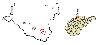
Smithfield is a town in Wetzel County, West Virginia, United States. The population was 103 at the 2020 census.

References

  1. "2019 U.S. Gazetteer Files". United States Census Bureau. Retrieved August 7, 2020.
  2. 1 2 "Total Population: 2010 Census DEC Summary File 1 (P1), Thornton town, Texas". data.census.gov. U.S. Census Bureau. Retrieved January 22, 2021.
  3. 1 2 "Population and Housing Unit Estimates". United States Census Bureau. May 24, 2020. Retrieved May 27, 2020.
  4. 1 2 "U.S. Census website". United States Census Bureau . Retrieved January 31, 2008.
  5. "US Board on Geographic Names". United States Geological Survey. October 25, 2007. Retrieved January 31, 2008.
  6. "US Gazetteer files: 2010, 2000, and 1990". United States Census Bureau. February 12, 2011. Retrieved April 23, 2011.
  7. Climate Summary for Thornton, Texas
  8. "Census of Population and Housing". Census.gov. Retrieved June 4, 2015.