Thorold

Last updated
Thorold
City of Thorold
Maplehurst.jpg
The Keefer Mansion Inn, previously Maplehurst
Thoroldflag.png
Logo of Thorold, Ontario.svg
Thorold-niagara.png
Location of Thorold in the Niagara Region
Canada Southern Ontario location map 2.png
Red pog.svg
Thorold
Location in southern Ontario
Coordinates: 43°07′N79°12′W / 43.117°N 79.200°W / 43.117; -79.200
CountryCanada
Province Ontario
Region Niagara
Incorporated 1850 (village)
 1870 (town)
 1975 (city)
Government
  MayorTerry Ugulini
  Governing bodyThorold City Council
   MP Vance Badawey
   MPP Jeff Burch
Area
[1]
  Land82.99 km2 (32.04 sq mi)
Elevation
162 m (531 ft)
Population
 (2016) [1]
  Total18,801
  Density226.5/km2 (587/sq mi)
Time zone UTC-5 (Eastern (EST))
  Summer (DST) UTC-4 (EDT)
Postal code
L2V, L2T, L0S
Area code(s) 905, 289, 365, and 742
Website www.thorold.ca

Thorold is a city in Ontario, Canada, located on the Niagara Escarpment. It is also the seat of the Regional Municipality of Niagara. The Welland Canal passes through the city, featuring lock 7 and the Twin Flight Locks.

Contents

History

The first survey of Thorold, or Township 9 as it was known then, occurred in 1788. The earliest communities in what is now Thorold emerged at Beaverdams, DeCew Falls and St. Johns [2] but, after the opening of the First Welland Canal in 1829, they were superseded by the new canal villages of Thorold, Allanburg and Port Robinson.

In 1846, the community had a population of about 1,000 and there were three churches or chapels and a post office. Various types of tradesmen worked here. Industry included two grist mills, a cement mill, a brewery and three wagon makers. There were seven taverns. [3]

Thorold, located on the brow of the Niagara Escarpment, soon became dominant and was incorporated as a village in 1850 and as a town in 1870. When the Regional Municipality of Niagara was formed in 1970, the Town of Thorold expanded to include the former Thorold Township. In 1975, the town became incorporated as the City of Thorold. [4]

Thorold is also the location of the War of 1812 battle site, Beaverdams, where, on June 25, 1813, Colonel Charles Boerstler and his American troops were defeated by the British regulars and Caughnawaga Mohawks. [5]

Geography

The city includes the neighbourhoods of Allanburg, Beaverdams, Confederation Heights, Port Robinson, St. Johns, Rolling Meadows, Thorold South and Turner's Corners.

St. Johns was one of the first areas in the interior of Niagara Peninsula to be settled by Europeans. The first Europeans settled in the area about 1792, when a sawmill was built on St. Johns Creek, a tributary of the Twelve Mile Creek. It was one of only two mills in Niagara at the time. In 1804, St. Johns became home to the first free school in Upper Canada, housed in a single-room, wooden schoolhouse. By the time a post office was established in 1831, the community included a woollen factory, a tannery, a foundry, stores, and a number of mills. Eventually, the hydro power offered by the site became less of a commodity. As industry in surrounding towns grew, St. Johns' affluence declined.

Demographics

Historical populations
YearPop.±%
18411,000    
18711,635+63.5%
19011,979+21.0%
1911 2,273+14.9%
19214,825+112.3%
19315,092+5.5%
19415,284+3.8%
19516,397+21.1%
19618,633+35.0%
197115,065+74.5%
198115,412+2.3%
199117,542+13.8%
1996 17,883+1.9%
2001 18,048+0.9%
2006 18,224+1.0%
2011 17,931−1.6%
2016 18,801+4.9%

In the 2021 Census of Population conducted by Statistics Canada, Thorold had a population of 23,816 living in 9,095 of its 9,856 total private dwellings, a change of

Arts and culture

Thorold is home to several festivals and annual events. Included are:

Attractions

Trails

The Welland Canal Parkway Trail is a paved recreational path beginning in St. Catharines at Lake Ontario and ending at Lake Erie in Port Colborne. Three sections of the trail are located within Thorold, which are:

The trail follows the Welland Canal, and passes next to the Thorold Lock 7 Viewing Complex.

Parks

Officially opened in 2002, the Mel Swart Lake Gibson Conservation Park is a 29-acre waterfront park located on Lake Gibson. [10] There are trails winding through the park as well as a main path along the perimeter. One of the main features of the park is the suspended boardwalk that runs along the shore of the lake. The Mel Swart - Lake Gibson Conservation Park is part of the Niagara Greenbelt. [11]

Short Hills Provincial Park is partially located in the City of Thorold.

Historical sites

DeCew House

On DeCew Road, DeCou House was constructed in the late 18th century as a home for British Captain John B. DeCou. It served as the area's British headquarters during the War of 1812. On June 22, 1813, Laura Secord journeyed from Queenston to DeCew House to warn Lieutenant James FitzGibbon of an impending American attack. FitzGibbon and his men were able to capture the American force and help turn the tide of the war. The house was destroyed by fire in 1950 but the site is commemorated by the rebuilt foundation and a plaque.

The Old Fire Hall

At 12 Albert Street West, was constructed next to the Second Welland Canal in 1878. This building once housed Thorold's police force and, to this day, contains a jail with 2 small cells and 1 larger in the basement. For many years, the fire bell tolled for the town's strictly enforced nine o'clock curfew. The Old Firehall was designed by the architect John Latshaw and built for $2,483. It has a combination bell tower and hose tower, yellow and red brickwork, semi-circular wood windows, and a circular wood window in the gable end at the tower. Decorative yellow brick arches frame each window. The bell which hung in its tower remained in use until 1964, when the fire department moved into its new hall on nearby Towpath Street. In 1967 the old bell was installed outside the new firehall. The "Old Hall" was used as the Thorold YMCA for several years thereafter. There are 3 holding cells in the basement. 2 are small and another larger one under the west side of the building.

Chestnut Hall

At 14 Ormond Street North, is a carefully restored 1862 building that was once home to John McDonagh, a lumber merchant and mayor of the Town of Thorold from 1881–1884.

St. Johns School House

On Hollow Road, is a single-room wooden school house located in the west portion of Thorold. Opening in 1804, it was the first free school in Upper Canada. The first teacher at the school was Samuel Birdsall. The enrolment in 1826 was recorded as 29 students. The building was fully restored in 1974.

Maplehurst

At 14 Saint David's Road West, is a Thorold landmark and the former home of Jacob Keefer. The mansion sits on the highest rise in the city offering a commanding view of the community below. Built by Hugh Keefer in 1885, this red stone structure with elaborate gables and dormers has been variously used in the past as a residence, a hospital, and a private nursing home. Maplehurst was recently restored to its original condition and is currently known as the Keefer Mansion, a 10-room inn.

Welland Mills

At 20 Pine Street North, was constructed in 1846 on the bank of the second Welland Canal by Jacob Keefer and, at that time, it contained the largest watermill in Canada. The Keefers were entrepreneurs and are considered one of Thorold's founding families. At its height, the mill was capable of manufacturing 300  barrels (89  tonnes) of flour per day and storing 70,000  bushels (1,900 tonnes) of wheat and 5,000 barrels (440 tonnes) of flour. Today, the Welland Mills building has been restored offering commercial space on the ground floor and residential apartments above.

Beaverdams Methodist Church and Cemetery

On Marlatt's Road, was constructed in 1832. Beaverdams Church is the oldest Methodist Church still standing in Ontario. The first minister to preach in the chapel was Reverend Egerton Ryerson, who is largely responsible for founding the province of Ontario's education system.

Soldiers' Monument

A war memorial monument that commemorates World War I, World War II and the Korean War. Located in Memorial Park, at the corner of Albert and Chapel streets, it was unveiled on Sunday, October 30, 1921 and was erected by the citizens of Thorold to: "Honour the Memory of the Men of Thorold, who gave their lives for the cause of freedom in the great war, and in grateful remembrance of those who shared its dangers."

The Old Public Library

At 1 Ormond Street South, is one of 156 Carnegie libraries to have been funded in Canada. The building, designed by architect A. E. Nicholson, was opened in 1912. The library moved from here to its present home in Chestnut Hall in 1983. The building now serves as office space.

Sports

Thorold Blackhawks

The Thorold Blackhawks, founded in 1963, are a Junior 'B' hockey team in the Greater Ontario Junior Hockey League. The Blackhawks were Golden Horseshoe Junior Hockey League Champions in 2001, 2003, 2004, 2005 and Golden Horseshoe Conference Champions in 2008. In 2005, the team went on to capture the Sutherland Cup as the best Junior 'B' team in Ontario. Notable former players include Nathan Horton, Dwayne Roloson, Conor Timmins and Owen Nolan. The Blackhawks home rink is the Thorold Community Arena in downtown Thorold. The team colours are black, white and red.

Infrastructure

Transportation

The Thorold Tunnel is an underwater vehicular tunnel, built between 1965 and 1967, which allows Highway 58 to cross the Welland Canal without interrupting shipping. Approximately 24,300 vehicles pass through the tunnel daily. [12]

Niagara Detention Centre

Thorold is home to the Niagara Detention Centre, a 260-person capacity maximum-security prison. It generally serves people on remand, offenders sentenced to short terms (60 days or less), and offenders awaiting transfer to larger federal or provincial facilities. [13] It is located between the neighbourhoods of Thorold South and Allanburg.

Notable people

See also

Related Research Articles

<span class="mw-page-title-main">St. Catharines</span> City in Ontario, Canada

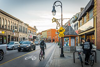
St. Catharines is the most populous city in Canada's Niagara Region, the eighth largest urban area in the province of Ontario. As of 2017, St. Catharines has an area of 96.13 square kilometres (37.12 sq mi) and 140,370 residents. It lies in Southern Ontario, 51 kilometres (32 mi) south of Toronto across Lake Ontario, and is 19 kilometres (12 mi) inland from the international boundary with the United States along the Niagara River. It is the northern entrance of the Welland Canal. Residents of St. Catharines are known as St. Catharinites. St. Catharines carries the official nickname "The Garden City" due to its 1,000 acres (4 km2) of parks, gardens, and trails.

<span class="mw-page-title-main">Welland</span> City in Ontario, Canada

Welland is a city in the Regional Municipality of Niagara in Southern Ontario, Canada. As of 2021, it had a population of 55,750.

<span class="mw-page-title-main">Port Colborne</span> City in Ontario, Canada

Port Colborne is a city in Ontario, Canada that is located on Lake Erie, at the southern end of the Welland Canal, in the Niagara Region of Southern Ontario. The original settlement, known as Gravelly Bay, dates from 1832 and was renamed after Sir John Colborne, a British war hero and the Lieutenant Governor of Upper Canada at the time of the opening of the (new) southern terminus of the First Welland Canal in 1833. The city's population in 2021 was 20,033.

<span class="mw-page-title-main">Welland Canal</span> Ship canal in Ontario, Canada, connecting Lake Ontario and Lake Erie

The Welland Canal is a ship canal in Ontario, Canada, and part of the St. Lawrence Seaway and Great Lakes Waterway. The canal traverses the Niagara Peninsula between Port Weller on Lake Ontario, and Port Colborne on Lake Erie, and was erected because the Niagara River—the only natural waterway connecting the lakes—was unnavigable due to Niagara Falls. The Welland Canal enables ships to ascend and descend the Niagara Escarpment, and has followed four different routes since it opened.

<span class="mw-page-title-main">Regional Municipality of Niagara</span> Regional municipality in Ontario, Canada

The Regional Municipality of Niagara, also colloquially known as the Niagara Region or Region of Niagara, is a regional municipality comprising twelve municipalities of Southern Ontario, Canada. The regional seat is in Thorold. It is the southern end of the Golden Horseshoe, the largest megalopolis in Canada.

King's Highway 58, commonly referred to as Highway 58, is a provincially maintained highway in the Canadian province of Ontario. The route is divided into two segments with a combined length of 15.5 km (9.6 mi). The southern segment travels from Niagara Regional Road 3, formerly Highway 3, in Port Colborne, to the Highway 58A junction in the southern end of Welland, a distance of 7.2 km (4.5 mi). The northern segment begins at Highway 20 near Allanburg and travels north and west to a large junction with Highway 406 at the St. Catharines – Thorold boundary, a distance of 8.3 km (5.2 mi). An 18.1 km (11.2 mi) gap separates the two segments within Welland and Pelham. The entire route is located within the Regional Municipality of Niagara.

Chippawa is a community located within the city of Niagara Falls, Ontario.

<span class="mw-page-title-main">Battle of Beaver Dams</span> War of 1812 battle

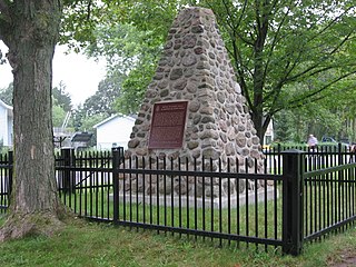
The Battle of Beaver Dams took place on 24 June 1813, during the War of 1812. A column of troops from the United States Army marched from Fort George and attempted to surprise a British outpost at Beaver Dams, billeting themselves overnight in the village of Queenston, Ontario. Laura Secord, a resident of Queenston, had earlier learned of the American plans from several Americans billeted at her house and had struck out on a long and difficult trek to warn the British at Decou's stone house near present-day Brock University. When the Americans resumed their march, they were ambushed by Kahnawake and other native warriors and eventually surrendered to a small British detachment led by Lieutenant James FitzGibbon. About 500 U.S. troops, including their wounded commander, were taken prisoner.

King's Highway 406, commonly referred to as Highway 406, is a 400-series highway in the Canadian province of Ontario. The primary north–south route through the central portion of the Niagara Peninsula, Highway 406 connects Welland, Thorold and downtown St. Catharines to the Queen Elizabeth Way (QEW).

<span class="mw-page-title-main">Cooks Mills, Welland</span> Unincorporated community in Ontario, Canada

Cooks Mills is a small community in the easternmost part of the city of Welland in Ontario, Canada. It was established, and is still centred, on a Welland River tributary called Lyons Creek. It is almost entirely a bedroom community, as there are few employers located in the area.

King's Highway 20, commonly referred to as Highway 20, is a provincially maintained highway in the Canadian province of Ontario. Presently, it is a short 1.9 km (1.2 mi) stub between Highway 58 and Niagara Regional Road 70 in the City of Thorold, but until 1997 it connected Hamilton to Niagara Falls, serving several towns atop the Niagara Escarpment en route.

<span class="mw-page-title-main">Lake Gibson (Ontario)</span> Lake in Regional Municipality of Niagara, Ontario

Lake Gibson is a lake near Thorold in the Regional Municipality of Niagara, Ontario, Canada. The lake is not natural, but rather was created as a reservoir for hydroelectric power generation at the Ontario Power Generation Decew Falls 1 and Decew Falls 2 generating stations. The lake was created by flooding the shallow valley of Beaverdams Creek. Lake Moodie is located to the northwest of Lake Gibson and is a smaller segment of the overall Lake Gibson system. Almost all of the water supply to these lakes comes from Lake Erie via the Welland Canal. The lakes form part of the Twelve Mile Creek watershed.

<span class="mw-page-title-main">William Hamilton Merritt</span> Upper Canada businessman and politician

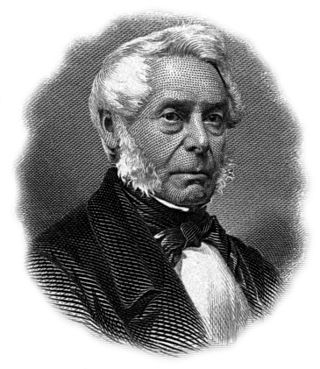
William Hamilton Merritt was a businessman and politician in the Niagara Peninsula of Upper Canada in the early 19th century. Although he was born in the United States, his family was Loyalist and eventually settled in Upper Canada. Merritt fought in the War of 1812, was captured by the invading American forces, and held as a prisoner of war. After the war, he returned to the Niagara region and began a career in business. He was one of the founders of the Welland Canal. He was a supporter of the Abolitionist cause to end slavery in the U.S., and of the settlement of escaped slaves in St. Catharines.

<span class="mw-page-title-main">Allanburg, Ontario</span> Unincorporated community in Ontario, Canada

Allanburg is a community within the City of Thorold, Ontario, Canada. It is located on the Welland Canal and Highway 20, both important transportation routes through the Niagara Peninsula. The two cross at a vertical-lift bridge, numbered as Bridge 11 by the Saint Lawrence Seaway Authority, but often known simply as the Allanburg Bridge. The collision of the ship Windoc with the bridge made national news in 2001.

<span class="mw-page-title-main">First Welland Canal</span> First phase of construction of the Welland Canal, Upper Canada (1824-29, 1831-33)

The Welland Canal has gone through many incarnations in its history. Today, five distinct canal-construction efforts are recognized. The retronym First Welland Canal is applied to the original canal, constructed from 1824 to 1829 and 1831 to 1833.

Twelve Mile Creek is a waterway located on the Niagara Peninsula in the Regional Municipality of Niagara in Southern Ontario, Canada. Its headwaters are located in the town of Pelham, encompassing some of the most unspoiled and natural areas of Niagara area. The creek's lower reaches flow through urban areas of Thorold and St. Catharines and has been heavily altered by human activity for almost two centuries. The creek was first known as "Ashquasing" by the Mississaugas Indigenous people, the name meaning "that which lies at the end" in the Anishinaabe language.

John DeCew (1766–1855), was a United Empire Loyalist, an early settler in the Niagara Peninsula of Upper Canada, a commissioned militia officer in the War of 1812, and a founding member of the Welland Canal Company.

<span class="mw-page-title-main">Welland Canal Bridge 11</span> Bridge in Ontario, Canada

Bridge 11, also known as the Allanburg Bridge, is a vertical-lift bridge over the Welland Canal within the City of Thorold and community of Allanburg, Ontario, Canada. The location was used for the groundbreaking ceremony for the canal. It was constructed and completed in 1930. The bridge carries Hwy 20 connecting Niagara Falls to Fonthill.

<span class="mw-page-title-main">Morningstar Mill</span> Heritage site in St. Catharines, Ontario, Canada

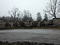
Morningstar Mill is a 2.98-acre (1.21 ha) heritage site located in St. Catharines, Ontario, Canada. The site includes the Morningstar Mill, a sawmill, the home of the Morningstar family, a barn used for blacksmith demonstrations, and the Decew Falls gorge along the Niagara Escarpment.

<span class="mw-page-title-main">Laura Secord Legacy Trail</span>

Laura Secord Legacy Trail is a 32-kilometer trail as a monument to Laura Secord's journey and legacy. It includes the Laura Secord Commemorative Walk that was established in 2013. Secord embarked on a journey in June 1813 during the War of 1812 from the Secord Homestead in Queenston, Niagara-on-the-Lake to deliver a message on 22 June 1813 to Lt. James FitzGibbon at the DeCew House in Thorold, Ontario.

References

  1. 1 2 "Thorold, Ontario census profile". 2016 Census of Population . Statistics Canada. Retrieved March 5, 2017.
  2. "History". Archived from the original on January 16, 2018.
  3. Smith, Wm. H. (1846). Smith's Canadian Gazetteer - Statistical and General Information Respecting all parts of The Upper Province, or Canada West. Toronto: H. & W. Rowsell. p.  191. Archived from the original on 2016-04-03. Retrieved 2018-03-11.
  4. Gayler, Hugh. "Thorold". The Canadian Encyclopedia. Retrieved 22 May 2021.
  5. Collins, Gilbert (2006). Guidebook to the Historic Sites of the War of 1812 (2 ed.). Dundern Press. p. 155. ISBN   9781550029147 . Retrieved 3 August 2022.
  6. "Population and dwelling counts: Canada, provinces and territories, census divisions and census subdivisions (municipalities), Ontario". Statistics Canada. February 9, 2022. Retrieved March 27, 2022.
  7. "Lock 7 Viewing Complex". Brock University and Tourism Niagara. Retrieved June 22, 2019.
  8. "Canal Bank Shuffle" . Retrieved April 24, 2019.
  9. Heslop, Bonnie. "NIAGARA'S ONLY DRIVE-IN MOVIE THEATRE IS FOR SALE FOR $10.8M". iHeart Radio. Retrieved 3 August 2022.
  10. "Community Parks - City of Thorold". City of Thorold. April 23, 2022. Retrieved April 23, 2022.
  11. "Community Parks - City of Thorold". City of Thorold. Retrieved April 23, 2022.
  12. Gannon, Dennis. "Yesterday and Today: The Thorold Tunnel turns 50". St. Catharines Standard. Retrieved 3 August 2022.
  13. "Niagara Detention Centre". Niagara Community Information Database. Archived from the original on July 29, 2012.
  14. Blay, Jeff. "Owen Nolan to be inducted into Thorold's Runway of Recognition". Niagara Falls Review. Retrieved 3 August 2022.
  15. 1 2 Lansbergen, Bernard. "Thorold hockey star enjoying shift to new career". ThoroldToday. Retrieved 3 August 2022.
  16. Liddycoat, Bob. "NHL dream come true for Timmins". ThoroldToday. Retrieved 3 August 2022.