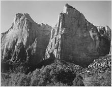
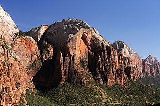
The Court of the Patriarchs' is a sandstone cliff on the south face of the Three Patriarchs in Zion Canyon in Zion National Park in Washington County, Utah, United States.

Mount Spry is a small 5,720-ft elevation mountain summit made of Navajo Sandstone located in Zion National Park, in Washington County of southwest Utah, United States. Officially named in 1934, it honors William Spry (1864-1929), the third governor of Utah. The nearest higher peak is The East Temple, 0.34 miles (0.55 km) to the east. Precipitation runoff from the mountain drains into tributaries of the North Fork Virgin River.

The West Temple is a prominent 7,810-foot mountain summit composed of Navajo Sandstone in Zion National Park in Washington County of Utah, United States. This, the highest feature in Zion Canyon, was originally called "Temp-o-i-tin-car-ur" meaning "Mountain without a trail" by the Paiute people. It was called Steamboat Mountain by local Mormon settlers before 1934, when the USGS officially changed it to its present name, which was applied by John Wesley Powell during his explorations in 1872. West Temple is situated two miles northwest of Springdale, Utah, one mile northeast of Mount Kinesava, and two miles west of the park headquarters. It is one of the notable landmarks in the park. The nearest higher peak is Windy Peak, 10.46 miles (16.83 km) to the north. Precipitation runoff from the mountain drains into tributaries of the Virgin River.

The Watchman is a 6,545-foot (1,995 m) sandstone mountain summit located in Zion National Park, in Washington County of southwest Utah, United States.

Mount Kinesava is a 7,285-foot (2,220 m) sandstone mountain summit located in Zion National Park, in Washington County of southwest Utah, United States.

Mount Moroni is a 5,690-foot (1,730 m) elevation Navajo Sandstone summit located at the Court of the Patriarchs in Zion National Park, in Washington County of southwest Utah, United States.

The Sentinel is a 7,120+ ft elevation Navajo Sandstone summit located near the Court of the Patriarchs in Zion National Park, in Washington County of southwest Utah, United States, that is part of the Towers of the Virgin. The national park map lists the elevation as 7,157-feet.

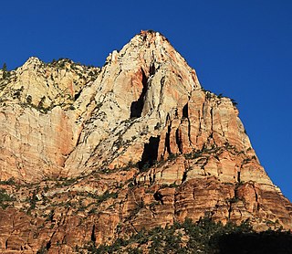
Cathedral Mountain is a 6,930-foot (2,110 m) elevation Navajo Sandstone summit located in Zion National Park, in Washington County of southwest Utah, United States.

Mountain of the Sun is a 6,722-foot (2,049 m) elevation Navajo Sandstone summit located in Zion National Park, in Washington County of southwest Utah, United States. Mountain of the Sun is situated immediately east of Court of the Patriarchs, and south of Zion Lodge, towering 2,500 feet above the lodge and the floor of Zion Canyon. It is set on the east side of the North Fork of the Virgin River which drains precipitation runoff from this mountain. Its neighbors include The Sentinel, Mount Spry, The East Temple, and Mount Moroni. This feature's name was officially adopted in 1934 by the U.S. Board on Geographic Names.
Lady Mountain is a 6,945-foot (2,117 m) elevation Navajo Sandstone summit located in Zion National Park, in Washington County of southwest Utah, United States.
Red Arch Mountain is a 5,930-foot (1,810 m) elevation Navajo Sandstone summit located in Zion National Park, in Washington County of southwest Utah, United States.

Twin Brothers is a 6,863-foot (2,092 m) Navajo Sandstone mountain in Zion National Park in Washington County, Utah, United States.

Three Marys are three sandstone pillars in Zion National Park in Washington County, Utah, United States.

Mountain of Mystery is a 6,565-foot (2,001 m) Navajo Sandstone summit located in Zion National Park, in Washington County of southwest Utah, United States. Mountain of Mystery is situated above The Narrows, towering over 2,100 feet above the floor of Zion Canyon and the North Fork Virgin River which drains precipitation runoff from this mountain. This peak rises above Orderville Canyon on its north side, and Mystery Canyon on the south. Its neighbors include Mount Majestic, Cathedral Mountain, Observation Point, Cable Mountain, Angels Landing, and The Organ. This feature's name was officially adopted in 1934 by the U.S. Board on Geographic Names. The first ascent via the Northeast Buttress was made 15 September 2001, by Brian Cabe and Tom Jones.

Shunesburg Mountain is a 5,960-foot (1,820 m) mountain in Zion National Park in Washington County, Utah, United States.

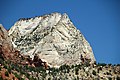
Crazy Quilt Mesa is a 6,760 ft (2,060 m) elevation white Navajo Sandstone summit located in Zion National Park, in Kane County of southwest Utah, United States.

Beatty Point is a 7,780-foot (2,370 m) elevation summit located in the Kolob Canyons area of Zion National Park in Washington County, Utah, United States.

Abraham Peak is a 2,000-foot (610 m) tall rock formation in Zion National Park in Washington County, Utah, United States. Access to Abraham Peak is from the main Park road through Sand Beach Trail. Abraham Peak is the tallest of the three peaks that make the Three Patriarchs. Across from Abraham Peak is prominent The Sentinel.
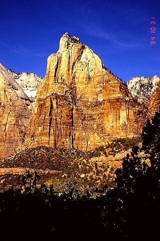
Isaac Peak is a 6,726-foot (2,050 m) rock formation in Zion National Park in Washington County, Utah, United States. Access to Isaac Peak is from the main Park road through Sand Beach Trail. Isaac Peak is part of the Three Patriarchs in between Abraham Peak and Jacob Peak. Between Isaac Peak and Abraham Peak is Isaac Canyon, accessed by climbing up the South Fork of Heaps Canyon.
Jacob Peak is a 6,873-foot (2,095 m) rock formation in Zion National Park in Washington County, Utah, United States. Jacob Peak is part of the Three Patriarchs, along with Abraham Peak and Isaac Peak.