| History of Cape Verde |
|---|
 |
| Colonial history |
| Independence struggle |
The following is a timeline of the city of Praia, capital of Cape Verde.
| History of Cape Verde |
|---|
| |
| Colonial history |
| Independence struggle |
The following is a timeline of the city of Praia, capital of Cape Verde.


Praia is the capital and largest city of Cape Verde. Located on the southern coast of Santiago island, within the Sotavento Islands group, the city is the seat of the Praia Municipality. Praia is the economic, political, and cultural center of Cape Verde.

Mindelo is a port city in the northern part of the island of São Vicente in Cape Verde. Mindelo is also the seat of the parish of Nossa Senhora da Luz, and the municipality of São Vicente. The city is home to 93% of the entire island's population. Mindelo is known for its colourful and animated carnival celebrations, with roots in Portuguese traditions later influenced by the Brazilian culture.

Cidade Velha is a city in the southern part of the island of Santiago, Cape Verde. Founded in 1462, it is the oldest settlement in Cape Verde and its former capital. Once called Ribeira Grande, its name was changed to Cidade Velha in the late 18th century. It is the seat of the Ribeira Grande de Santiago municipality.

São Nicolau is one of the Barlavento (Windward) islands of Cape Verde. It is located between the islands of Santa Luzia and Sal. Its population is 12,424 (2015), with an area of 343 km2 (132 sq mi). The main towns are Ribeira Brava and Tarrafal de São Nicolau.

Boa Vista, also written as Boavista, is a desert-like island that belongs to the Cape Verde Islands. At 631.1 km2 (243.7 sq mi), it is the third largest island of the Cape Verde archipelago.
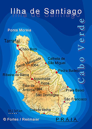
Santiago is the largest island of Cape Verde, its most important agricultural centre and home to half the nation's population. Part of the Sotavento Islands, it lies between the islands of Maio and Fogo. It was the first of the islands to be settled: the town of Ribeira Grande was founded in 1462. Santiago is home to the nation's capital city of Praia.

Assomada is a city on the Sotavento (leeward) island of Santiago in Cape Verde. Since 1912, it is the seat of the municipality of Santa Catarina, which comprises the central western part and much of the interior of the island. It is the largest city in that region.

The University of Cape Verde is the only public university of Cape Verde. The main campus is in Palmarejo, Praia, but there are also institutes in Mindelo, Assomada and São Jorge dos Órgãos. It has over 5000 students. A new campus for Uni-CV is under construction in Palmarejo, financed by the Chinese government. It should be completed by July 2020. It will have capacity for 4,890 students and 476 professors, with a library, dorms, cafeterias and sports facilities. It will have 61 class rooms, five auditoriums with a capacity of 150 seats, eight computer rooms, eight reading rooms and 34 laboratories.

Primary school education in Cape Verde is mandatory between the ages of 6–14 and free for children ages 6–12. In 1997, the gross primary enrollment rate was 148.8%. Primary school attendance rates were unavailable for Cape Verde as of 2001. While enrollment rates indicate a level of commitment to education, they do not always reflect children's participation in school. Textbooks have been made available to 90% of school children, and 90% of teachers have attended in-service teacher training. Its literacy rate as of 2010 ranges from 75 to 80%, the highest in West Africa south of the Sahara.

Cape Verde was a colony of the Portuguese Empire from the initial settlement of the Cape Verde Islands in 1462 until the independence of Cape Verde in 1975.

The Arquivo Nacional de Cabo Verde is the national archive of Cape Verde. It is located in the capital city of Praia, on Avenida Combatentes da Liberdade da Patria, in the subdivision of Chã de Areia. It is housed in the former customs building, that was built in 1878.
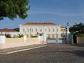
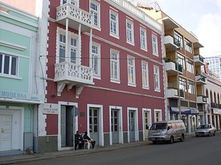
Plateau is the historic centre of the capital city of Praia in the island of Santiago, Cape Verde. It gets its name because it is situated on a plateau overlooking the port of Praia. Its average elevation is 37 meters above sea level. The population of Plateau was 1,019 at the 2010 census. Many public buildings are situated in Plateau, notably the Presidential Palace, the cathedral, the city hall and the Ethnographic Museum.
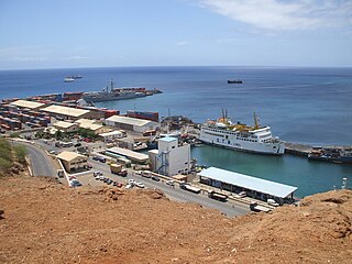
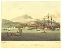
Praia Harbor is the port of the city of Praia in the southern part of the island of Santiago, Cape Verde. It is situated in a natural bay of the Atlantic Ocean. Since the latest modernization in 2014, it has 2 long quays, 3 shorter quays, a quay for fishing boats with fish processing installations, 2 container parks, 2 roll-on/roll-off ramps and a passenger terminal. The total length of the quays is 863 m, and the maximum depth is 13.5 m. The port of Praia played an important role in the colonization of Africa and South America by the Portuguese. With 817,845 metric tonnes of cargo and 85,518 passengers handled (2017), it is the second busiest port of Cape Verde, after Porto Grande (Mindelo).

Avenida Amílcar Cabral is an avenue in the Plateau, the historic centre of Praia, Santiago island, Cape Verde. It is the neighborhood's longest street and the main artery of the city centre. Formerly named Rua Sá da Bandeira after 19th century Portuguese politician Sá da Bandeira, it was renamed after Cape Verdean independence in honour of Amílcar Cabral, leader of the independence movement of Cape Verde and Guinea-Bissau. It runs south to north in the western part of the Plateau, parallel to Rua 5 de Julho, Rua Serpa Pinto and Avenida Andrade Corvo. It forms the west side of Praça Alexandre Albuquerque.
The following lists events that happened during 1996 in Cape Verde.
The following lists events that happened during 1992 in Cape Verde.
The following lists events that happened during 1979 in Cape Verde.
The following lists events that happened during 1980 in Cape Verde.
João Lopes Filho is a Cape Verdean anthropologist, historian, university professor, novelist and an investigator.

Liceu Domingos Ramos is a public secondary school in the northern part of the city centre (Plateau) of Praia, Cape Verde. As of 2015, it has 2,300 students, 63 classes and 110 teachers. It was established as Liceu Adriano Moreira in 1960. In 1975, at the independence of Cape Verde, it was renamed Liceu Domingos Ramos.
| Neighbourhoods |   | |
|---|---|---|
| Geographical features | ||
| Education | ||
| Landmarks | ||
| Culture | ||
| Sports | ||
| Transportation | ||
| Media | ||
| History | ||
Timelines of cities in Africa | |
|---|---|
| North | |
| West |
|
| Central |
|
| East |
|
| South |
|