Timor and Wetar deciduous forests

Last updated
Timor and Wetar deciduous forests
Gebang 080717 1306 ayot.JPG
Corypha utan palms in hilly savanna near Ayotupas, West Timor
Timor and Wetar Endemic Bird Area.png
Ecoregion territory (highlighted islands)
Ecology
Realm Australasian realm
Biome tropical and subtropical dry broadleaf forests
Geography
Area33,091 km2 (12,777 sq mi)
Countries
Provinces of Indonesia
Coordinates 9°06′S125°06′E / 9.1°S 125.1°E / -9.1; 125.1
Conservation
Conservation status Critical/endangered
Protected2,245 km2 (7%) [1]

The Timor and Wetar deciduous forests is a tropical dry forest ecoregion in Indonesia and East Timor. The ecoregion includes the islands of Timor, Wetar, Rote, Savu, and adjacent smaller islands. [2] [3] [4]

Contents

Geography

Timor, Wetar, Rote, and Savu are part of the Lesser Sunda Islands. The ecoregion is part of Wallacea, a group of islands that are part of the Australasian realm, but were never joined to either the Australian or Asian continents. The islands of Wallacea are home to a mix of plants and animals from both terrestrial realms, and have many unique species that evolved in isolation. [5]

Timor is the largest of the islands at 30,777 km2. Timor is politically divided; The independent country of Timor Leste is on the eastern portion of Timor, and western Timor and the other islands are part of Indonesia. Western Timor, Rote, and Savu are part of East Nusa Tenggara province, while Wetar is part of Maluku Province.[ citation needed ]

The islands are mostly mountainous, and Tatamailau on Timor is the highest point at 2986 meters elevation. Wetar reaches 1,407 meters elevation.

Climate

The ecoregion has a tropical monsoon climate. The islands are in the rain shadow of Australia, and are among the driest in Indonesia. Rainfall is strongly seasonal, and April through November are generally the driest months. The windward southern side of the islands and receive annual rainfall of 2000 mm or more, with a two- to four-month dry season with less than 100 mm per month. The leeward north side of the island is much drier, receiving 1000 mm or less, with nine or more dry months. Some south-facing mountain areas above 900 meters elevation are humid year-round. [6] [7]

Flora

Forest types include lowland evergreen rain forests, montane evergreen rain forests, semi-evergreen rain forests, moist deciduous forests, dry deciduous forests, and thorn forest/scrub. Evergreen and semi-evergreen rain forests occur in high-rainfall areas on the south side of the island. Deciduous forests and thorn forests are more widespread. Little primary forest remains; most forests are secondary. Extensive burning for shifting cultivation, grazing by goats and other livestock, and tree harvesting has reduced much of the island to anthropogenic grassland and scrub, including many invasive exotic shrubs. [8] [9]

Savannas are common in the lowlands, and are of four types – palm savanna with Borassus flabellifer , eucalyptus savanna with Eucalyptus alba , acacia savanna, and casuarina savanna. Other plant communities include coastal dune grasslands and shrublands, [10]

Sandalwood ( Santalum album ) and candle nut ( Aleurites moluccanus ) are important tree crops harvested from the wild. Sandalwood was economically important, but over-harvesting has left it scarce and critically endangered.

Fauna

The ecoregion has thirty-eight mammal species. [11] The Timor shrew (Crocidura tenuis) and Timor rat (Rattus timorensis) are endemic. Two species were believed to have been brought to the islands long ago by humans – the Northern common cuscus (Phalanger orientalis), a marsupial originating in New Guinea, and the Javan rusa (Rusa timorensis), a deer originating in Java and Bali. [12] [13]

The ecoregion is home to 229 bird species. [14] It corresponds to the Timor and Wetar endemic bird area. 23 species are endemic. [15]

Extinct fauna

Giant rats in the genus Coryphomys are believed to have gone extinct 1000–2000 years ago. Fossils of two species of Stegodon , an elephant relative, have been found on Timor, the most recent approximately 130,000 years old. [16] Mid-Pleistocene fossils of a giant monitor lizard, similar in size and related to the living Komodo dragon found on Flores and neighboring islands, have also been found on Timor.[ citation needed ]

Protected areas

A 2017 assessment found that 2,245 km2, or 7%, of the ecoregion is in protected areas. About half the unprotected area is still forested. [17] Protected areas include Nino Konis Santana National Park (588.99 km²) and Kay Rala Xanana Gusmão National Park (92.31 km²) in East Timor.

Related Research Articles

<span class="mw-page-title-main">Odisha semi-evergreen forests</span> Ecoregion of India

The Odisha semi-evergreen forests are a tropical moist broadleaf forest ecoregion of eastern India. The ecoregion covers an area of 8,600 square kilometers (3,300 sq mi) on the coastal plain of Odisha state, bounded by the Eastern Highlands moist deciduous forests west and north-west, transitioning from the huge ecoregion Lower Gangetic Plains moist deciduous forests along the north coastland, and surrounding the smaller ecoregion Godavari-Krishna mangroves along a stretch of the south-east coast by the Bay of Bengal.

<span class="mw-page-title-main">Northern New Guinea lowland rain and freshwater swamp forests</span> Ecoregion in New Guinea

The Northern New Guinea lowland rain and freshwater swamp forests is a tropical moist broadleaf forest ecoregion of northern New Guinea.

<span class="mw-page-title-main">Mizoram–Manipur–Kachin rain forests</span> Ecoregion in Indochina

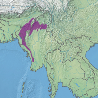
The Mizoram–Manipur–Kachin rain forests is a subtropical moist broadleaf forest ecoregion which occupies the lower hillsides of the mountainous border region joining Bangladesh, China's Yunnan Province, India, and Myanmar. The ecoregion covers an area of 135,600 square kilometres (52,400 sq mi). Located where the biotas of the Indian Subcontinent and the Indochinese Peninsula meet, and in the transition between subtropical and tropical regions of Asia, the Mizoram–Manipur–Kachin rain forests are home to great biodiversity. The WWF rates the ecoregion as "Globally Outstanding" in biological distinctiveness.

<span class="mw-page-title-main">Banda Sea Islands moist deciduous forests</span> Ecoregion in Banda Sea, Indonesia

The Banda Sea Islands moist deciduous forests is a tropical moist forest ecoregion in Indonesia. The ecoregion includes several island groups in the southwestern Banda Sea, including the Tanimbar Islands, Kai Islands, and the Barat Daya Islands except for Wetar.

<span class="mw-page-title-main">Halmahera rain forests</span> Ecoregion in Halmahera, Indonesia

The Halmahera rain forests is a tropical moist forest ecoregion in Indonesia. The ecoregion includes the island of Halmahera and neighboring islands, including Bacan, Morotai, the Obi Islands, Ternate, Tidore, Gebe, and many smaller islands.

<span class="mw-page-title-main">Lesser Sundas deciduous forests</span> Ecoregion in Lesser Sundas, Indonesia

The Lesser Sundas deciduous forests is a tropical dry forest ecoregion in Indonesia. The ecoregion includes the islands of Lombok, Sumbawa, Komodo, Flores, and Alor, along with the many adjacent smaller islands.

<span class="mw-page-title-main">Irrawaddy dry forests</span> Ecoregion in Myanmar

The Irrawaddy dry forests is a tropical dry broadleaf forest ecoregion in central Myanmar. The ecoregion occupies portions of the Irrawaddy, Sittaung, and Salween river basins, in areas with less than 800 mm of annual rainfall.

<span class="mw-page-title-main">Tenasserim–South Thailand semi-evergreen rain forests</span> Ecoregion on Mainland Southeast Asia

The Tenasserim–South Thailand semi-evergreen rain forests is a tropical moist broadleaf forest ecoregion on Mainland Southeast Asia. The ecoregion extends north–south along the Kra Isthmus. It includes lowland forests along the coasts, and montane forests on the Tenasserim Hills and Bilauktaung range, which form the mountainous spine of the isthmus.

<span class="mw-page-title-main">Irrawaddy moist deciduous forests</span> Ecoregion in Myanmar

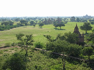
The Irrawaddy moist deciduous forests is a tropical moist broadleaf forest ecoregion in central Myanmar. The ecoregion occupies the central basin of the Irrawaddy River and the lower basin of the Salween River. The ecoregion is characterized by forests of tall trees which drop their leaves in the dry season. Most of the ecoregion's forests have been converted to agriculture.

<span class="mw-page-title-main">Kayah–Karen montane rain forests</span> Ecoregion on Mainland Southeast Asia

The Kayah–Karen montane rain forests is a tropical moist broadleaf forest ecoregion on Mainland Southeast Asia. The montane rain forests cover several connected mountain ranges, including the Daen Lao Range, the Dawna Range, the Karen Hills, the Khun Tan Range, and the Thanon Thong Chai Range.

<span class="mw-page-title-main">Chao Phraya lowland moist deciduous forests</span> Ecoregion in Central Thailand

The Chao Phraya lowland moist deciduous forests is a tropical moist broadleaf forest ecoregion in Thailand. The ecoregion occupies the coastal lowlands along the Gulf of Thailand lying east and west of the Chao Phraya River.

<span class="mw-page-title-main">Seram rain forests</span> Ecoregion in Seram, Indonesia

The Seram rain forests is a tropical moist forest ecoregion in Indonesia. The ecoregion includes the island of Seram and neighboring islands.

<span class="mw-page-title-main">Sulawesi lowland rain forests</span> Ecoregion in Sulawesi, Indonesia

The Sulawesi lowland rain forests is a tropical moist forest ecoregion in Indonesia. The ecoregion includes the lowlands of Sulawesi and neighboring islands.

<span class="mw-page-title-main">Sulawesi montane rain forests</span> Ecoregion in Sulawesi, Indonesia

The Sulawesi montane rain forests is a tropical moist forest ecoregion in Indonesia. It includes the highlands of Sulawesi.

<span class="mw-page-title-main">Vogelkop montane rain forests</span> Ecoregion in New Guinea

The Vogelkop montane rain forests is a tropical moist forest ecoregion in western New Guinea. The ecoregion covers the mountains of western New Guinea's Bird's Head and Bomberai peninsulas.

<span class="mw-page-title-main">Southeastern Papuan rain forests</span>

The Southeastern Papuan rain forests is a tropical moist forest ecoregion in southeastern New Guinea. The ecoregion covers the mountainous center and coastal lowlands of the Papuan Peninsula.

<span class="mw-page-title-main">Southern New Guinea lowland rain forests</span> Ecoregion in New Guinea

The Southern New Guinea lowland rain forests is a tropical moist forest ecoregion in southeastern New Guinea. The ecoregion covers portions of New Guinea's southern lowlands.

<span class="mw-page-title-main">Southern New Guinea freshwater swamp forests</span> Ecoregion in New Guinea

The Southern New Guinea freshwater swamp forests is a tropical moist forest ecoregion in southern New Guinea. The ecoregion includes the extensive swamp forests of southern and western New Guinea.

References

  1. Eric Dinerstein, David Olson, et al. (2017). An Ecoregion-Based Approach to Protecting Half the Terrestrial Realm, BioScience, Volume 67, Issue 6, June 2017, Pages 534–545; Supplemental material 2 table S1b.
  2. "Map of Ecoregions 2017". Resolve. Retrieved August 20, 2021.
  3. "Timor and Wetar deciduous forests". Digital Observatory for Protected Areas. Retrieved August 20, 2021.
  4. "Timor and Wetar deciduous forests". The Encyclopedia of Earth. Retrieved August 20, 2021.
  5. Wikramanayake, Eric; Eric Dinerstein; Colby J. Loucks; et al. (2002). Terrestrial Ecoregions of the Indo-Pacific: a Conservation Assessment. Washington, DC: Island Press.
  6. BirdLife International (2020) Endemic Bird Areas factsheet: Timor and Wetar. Downloaded from http://www.birdlife.org on 24/05/2020.
  7. Cowie, Ian (2006). "A Survey of Flora and Vegetation of the Proposed Jaco– Tutuala–Lore National Park, Timor-Leste (East Timor)". Birdlife International, May 2006.
  8. Cowie, Ian (2006). "A Survey of Flora and Vegetation of the Proposed Jaco– Tutuala–Lore National Park, Timor-Leste (East Timor)". Birdlife International, May 2006.
  9. Timor-Leste’s Fourth National Report to the UN Convention on Biological Diversity. National Biodiversity Working Group, Ministry of Economy and Development, Democratic Republic of Timor-Leste. October 2011.
  10. Wikramanayake, Eric; Eric Dinerstein; Colby J. Loucks; et al. (2002). Terrestrial Ecoregions of the Indo-Pacific: a Conservation Assessment. Washington, DC: Island Press.
  11. Wikramanayake, Eric; Eric Dinerstein; Colby J. Loucks; et al. (2002). Terrestrial Ecoregions of the Indo-Pacific: a Conservation Assessment. Washington, DC: Island Press.
  12. Grubb, P. (2005). "Rusa timorensis". In Wilson, D.E.; Reeder, D.M (eds.). Mammal Species of the World: A Taxonomic and Geographic Reference (3rd ed.). Johns Hopkins University Press. p. 670. ISBN   978-0-8018-8221-0. OCLC   62265494.
  13. Leary, T.; Singadan, R.; Menzies, J.; Helgen, K.; Wright, D.; Allison, A.; Hamilton, S.; Salas, L.; Dickman, C. (2016). "Phalanger orientalis". IUCN Red List of Threatened Species . 2016: e.T16847A21951519. doi: 10.2305/IUCN.UK.2016-2.RLTS.T16847A21951519.en . Retrieved 21 May 2020.
  14. Wikramanayake, Eric; Eric Dinerstein; Colby J. Loucks; et al. (2002). Terrestrial Ecoregions of the Indo-Pacific: a Conservation Assessment. Washington, DC: Island Press.
  15. BirdLife International (2020) Endemic Bird Areas factsheet: Timor and Wetar. Downloaded from http://www.birdlife.org on 21/05/2020.
  16. Louys J, Price GJ, O’Connor S. 2016. Direct dating of Pleistocene stegodon from Timor Island, East Nusa Tenggara. PeerJ 4:e1788 https://doi.org/10.7717/peerj.1788
  17. Eric Dinerstein, David Olson, et al. (2017). An Ecoregion-Based Approach to Protecting Half the Terrestrial Realm, BioScience, Volume 67, Issue 6, June 2017, Pages 534–545; Supplemental material 2 table S1b.