
The Toiyabe Range is a mountain range in Lander and Nye counties, Nevada, United States. Most of the range is included within the Humboldt-Toiyabe National Forest. The highest point in the range, near its southern end, is Arc Dome, an area protected as the Arc Dome Wilderness. The highest point in Lander County, Bunker Hill, is also located within the Toiyabe Range. The range starts in northwestern Nye County north of Tonopah, Nevada and runs approximately 120 miles (190 km) north-northeast into southern Lander County, making it the second longest range in the state.

Austin is an unincorporated small town in, and former county seat of, Lander County, Nevada, United States. In 2020, the census-designated place of Austin had a population of 167. It is located on the western slopes of the Toiyabe Range at an elevation of 6,575 feet (2,004 m). U.S. Route 50 passes through the town.

Mount Charleston, including Charleston Peak at 11,916 feet (3,632 m), is the highest mountain in both the Spring Mountains and Clark County, in Nevada, United States. It is the eighth-highest mountain in the state. Well separated from higher peaks by large, low basins, Charleston Peak is the most topographically prominent peak in Nevada, and the eighth-most-prominent peak in the contiguous United States. It is one of eight ultra-prominent peaks in Nevada. It is located about 35 miles (56 km) northwest of Las Vegas within the Mount Charleston Wilderness, which is within the Spring Mountains National Recreation Area of the Humboldt–Toiyabe National Forest.

Lake Tahoe–Nevada State Park is a state park comprising multiple management units and public recreation areas on the northeast shores of Lake Tahoe in the U.S. state of Nevada. The park covers approximately 14,301 acres (5,787 ha). The Marlette Lake Water System, which is listed on the National Register of Historic Places and as a National Historic Civil Engineering Landmark, lies within park boundaries.

Manhattan is an unincorporated town in Nye County, Nevada, located at the end of Nevada State Route 377, about 50 miles (80 km) north of Tonopah, the county seat.

The Mt. Moriah Wilderness is a 89,790-acre (36,340 ha) wilderness area in the northern part of the Snake Range of White Pine County, in the eastern section of the state of Nevada in the western United States.

The Alta Toquima Wilderness is a protected wilderness area in the Toquima Range of Nye County, in the central section of the state of Nevada in the western United States. It covers an area of 35,860 acres (14,510 ha), and is administered by the Humboldt-Toiyabe National Forest. The Mount Jefferson Research Natural Area protects 4,953 acres (2,004 ha) around Mount Jefferson, the highest peak in the Toquima Range and Nye County. The Mount Jefferson Research Natural Area is one of the most unusual environments in the United States, due to its extreme alpine conditions. Wildlife is plentiful in the Wilderness, including bighorn sheep, deer, grouse, chukar and native trout.


Mount Jefferson is the highest mountain in both the Toquima Range and Nye County in Nevada, United States. It is the sixth highest mountain in the state. As the high point of a range which is well separated from other ranges by low basins, Mount Jefferson has a high topographic prominence of 5,861 feet (1,786 m). This makes it the most prominent peak in Nye County and the third most prominent peak in Nevada. For similar reasons, it is also the highest mountain for over 90 miles in all directions. It is located about 50 miles (80 km) northeast of the county seat of Tonopah within the Alta Toquima Wilderness of the Humboldt-Toiyabe National Forest, near the smaller towns of Carvers and Round Mountain. Three distinct summits are located on a broad area of subalpine tundra: North Summit rises to 11,820 feet (3,603 m), Middle Summit to 11,692 feet (3,564 m), and South Summit to 11,949 feet (3,642 m). During the Pleistocene, alpine glaciers eroded several cirques east of the summit plateau.

Spirit Mountain, also known as Avi Kwa Ame is a mountain within the Lake Mead National Recreation Area near Laughlin, Nevada. It is listed on the United States National Register of Historic Places as a sacred place to Native American tribes in Southern Nevada. Spirit Mountain is the highest point in the Spirit Mountain Wilderness and is the highest point in the Newberry Mountains with the summit peak at 5,639 feet (1,719 m).

Gatecliff Rockshelter (26NY301) is a major archaeological site in the Great Basin area of the western United States that provides remarkable stratigraphy; it has been called the "deepest archaeological rock shelter in the Americas". Located in Mill Canyon of the Toquima Range in the Monitor Valley of central Nevada, Gatecliff Rockshelter has an elevation of 7,750 feet (2,360 m). David Hurst Thomas discovered Gatecliff Rockshelter in 1970 and began excavations in 1971. Full scale excavations occurred at Gatecliff Rockshelter for about seven field seasons in which nearly 33 feet (10 m) of sediments were exposed for a well-defined stratigraphic sequence. The well-preserved artifacts and undisturbed sediments at Gatecliff Rockshelter provides data and information have been applied to a range of research topics. Based on the analysis of the artifacts at Gatecliff Rockshelter, it can be determined that it was most likely a short-term field camp throughout prehistory. The latest evidence for human usage at Gatecliff occurs between ca. 5500 B.P. to 1250 B.P.
Fort Ruby, also known as Camp Ruby, was built in 1862 by the United States Army, during the American Civil War, in the "wilderness of eastern Nevada." It protected the overland mail coaches and Pony Express, in order to maintain links and communication between residents of California and the Union. It was operated 1862 to 1869, in territory dominated by bands of the Western Shoshone. The fort was located at the east entrance to the Overland Pass from Ruby Valley, near Hobson on the west side of Ruby Lake.
Toquima National Forest was established by the U.S. Forest Service in Nevada on April 15, 1907 with 368,000 acres (1,490 km2). On July 1, 1908 the entire forest was transferred to Toiyabe National Forest and the name was discontinued.

The Thunderbird Lodge, also known as the Whittell Estate, is a historic 6.51-acre (2.63 ha) waterfront estate located on the east shore of Lake Tahoe, in western Washoe County, Nevada. It is now within Lake Tahoe – Nevada State Park.

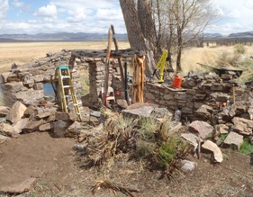
The Berlin Historic District encompasses the ghost town of Berlin in Nye County, Nevada. The town was established in 1897 as part of the Union Mining District after the opening of the Berlin Mine the previous year. The name is a transfer from Berlin, in Germany, the native land of a share of the local prospectors. The town never prospered to the same extent as other boom towns like Tonopah and Goldfield, and declined following the Panic of 1907. The town was largely abandoned by 1911. The site was acquired by the state of Nevada as part of Berlin–Ichthyosaur State Park in 1970.

Baker Ranger Station was established in 1911 at the edge of Baker, Nevada to administer U.S. government lands in White Pine County, Nevada. The original 80 acres (32 ha) plot was first known as the Baker Administrative Site, becoming a year-round ranger station in 1918 for the Baker Ranger District of Nevada National Forest. The compound became a guard station and work site with the division of Nevada National Forest into Humboldt and Toiyabe National Forests in 1957. In 1986 Great Basin National Park was established and the station was transferred to the National Park Service as an administrative center for the park.
Toiyabea is a genus of North American plants in the aster tribe within the daisy family. The genus is named for the Toiyabe Mountains in the US state of Nevada. The only known species is Toiyabea alpina, the alpine serpentweed, native to the Toiyabe and Toquima Mountains of central Nevada.
Gypsum Cave is a limestone cave in eastern Clark County, Nevada, United States, about 15 miles (24 km) east of Las Vegas, that is listed on the National Register of Historic Places (NRHP).

Humboldt Cave is an archeological site in Churchill County, Nevada. Thirty-one caches were excavated from the cave, but there is only one radiocarbon date of 1953±175 14C BP from the cave, which suggests that Humboldt Cave may have only been a single cultural component. In other words, the caches from the cave may have only been deposited once and at the same time.
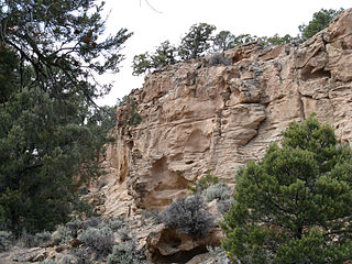
The Hickison Petroglyph Recreation Area provides public access to petroglyphs created by prehistoric people living near Hickison Summit at the north end of the Toquima Range and the south end of the Simpson Park Mountains in the U.S. state of Nevada. The recreation area, maintained by the Bureau of Land Management, is 24 miles (39 km) east of Austin along U.S. Route 50. The site, at 6,500 feet (2,000 m) above sea level, is on the west edge of the Monitor Valley in the Great Basin.


