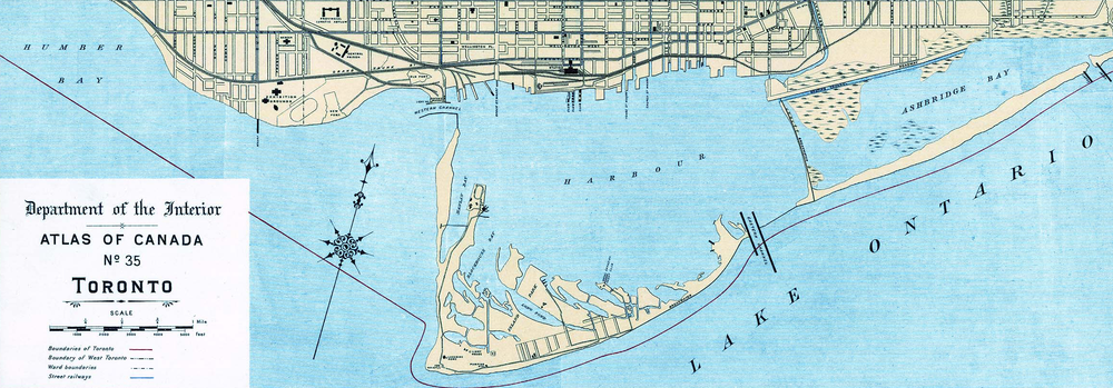
The Toronto Islands —are a chain of 15 small islands in Lake Ontario, south of mainland Toronto, Ontario, Canada.

Billy Bishop Toronto City Airport is a regional airport located on the Toronto Islands in Toronto, Ontario, Canada. It is often referred to as Toronto Island Airport and was previously known as Port George VI Island Airport and Toronto City Centre Airport. The airport's name honours Billy Bishop, the Canadian World War I flying ace and World War II Air Marshal. It is used by civil aviation, air ambulances, and regional airlines using turboprop planes. In 2019, it was ranked Canada's ninth-busiest airport, and the sixth-busiest Canadian airport that serves the U.S.

St. Lawrence is a neighbourhood located in downtown Toronto, Ontario, Canada. The area, a former industrial area, is bounded by Yonge, Front, and Parliament Streets, and the Canadian National railway embankment. The Esplanade off Yonge St., lined with restaurants, cafés and hotels runs through the middle of the area. In previous times, the area was sometimes referred to as 'St. Lawrence Ward' or more often today as 'St. Lawrence Market', synonymous with the large retail vendor market which is the neighbourhood's focal point. The area is the site of a large city-sponsored housing project of the 1970s, which revitalized an old 'brownfields' area. The boundaries of the St Lawrence Neighbourhood Association and the St Lawrence Market BIA are somewhat larger than those noted above. Both groups have boundaries that extend from Yonge to Parliament Streets and Queen Street East to the rail corridor.

Harbourfront is a neighbourhood on the northern shore of Lake Ontario within the downtown core of the city of Toronto, Ontario, Canada. Part of the Toronto waterfront, Harbourfront extends from Bathurst Street in the west, along Queens Quay, with its ill-defined eastern boundary being either Yonge Street or York Street. Its northern boundary is the Gardiner Expressway. Much of the district was former water lots filled in during the early 1900s to create a larger harbour district. After shipping patterns changed and the use of the Toronto harbour declined, the area was converted from industrial uses to a mixed-use district that is mostly residential and leisure.

The Toronto waterfront is the lakeshore of Lake Ontario in the city of Toronto, Ontario, Canada. It spans 46 kilometres between the mouth of Etobicoke Creek in the west and the Rouge River in the east.

Toronto Harbour or Toronto Bay is a bay on the north shore of Lake Ontario, in Toronto, Ontario, Canada. It is a natural harbour, protected from Lake Ontario waves by the Toronto Islands. Today, the harbour is used primarily for recreational boating, including personal vessels and pleasure boats providing scenic or party cruises. Ferries travel from docks on the mainland to the Islands, and cargo ships deliver aggregates and raw sugar to industries located in the harbour. Historically, the harbour has been used for military vessels, passenger traffic and cargo traffic. Waterfront uses include residential, recreational, cultural, commercial and industrial sites.

The Leslie Street Spit, or officially the Outer Harbour East Headland, is a man-made headland in Toronto, Ontario, Canada, extending from the city's east end in a roughly southwesterly direction into Lake Ontario. It is about 5 kilometres (3 mi) long. The Spit is the result of five decades of lakefilling by the Toronto Port Authority. It was conceived as an extension of Toronto Harbour, and has evolved into a largely passive recreation area. Naturalization had not been planned but the process is now actively managed by the Toronto Region Conservation Authority. A large portion of it is classified as an Environmentally Sensitive Area (ESA) and it is recognized as an Important Bird Area.

The Toronto Port Authority (TPA), doing business as PortsToronto (PT), is responsible for the management of the Port of Toronto, including the International Marine Passenger Terminal, and Billy Bishop Toronto City Airport. It was established under the Canada Marine Act as a government business enterprise that is self-funded, with directors appointed by three levels of government – the Government of Canada, the Government of Ontario and the City of Toronto. The TPA rebranded itself as PortsToronto in 2015.

Lake Shore Boulevard is a major arterial road running along more than half of the Lake Ontario waterfront in the city of Toronto, Ontario, Canada. Prior to 1998, two segments of Lake Shore Boulevard were designated as part of Highway 2, with the highway following the Gardiner Expressway between these two sections.

The Toronto Island ferries connect the Toronto Islands in Lake Ontario to the mainland of Toronto, Ontario, Canada. The main city-operated ferry services carry passengers (all) and commercial vehicles (some) from the Jack Layton Ferry Terminal at the foot of Bay Street to three docks on the islands. Private motor vehicles are not carried. The ferry operated by PortsToronto carries passengers and vehicles to Billy Bishop Toronto City Airport on the island from the foot of Eireann Quay. Additional private ferries carry passengers to various island boat clubs. Ferry services to the islands began in 1833, and the Toronto Island Ferry company began in 1883.

Sunnyside is a lakefront district in Toronto, Ontario, Canada. It includes a beach and park area along Lake Ontario's Humber Bay, from west of Exhibition Place to the mouth of the Humber River. The area has several recreation uses, including rowing clubs, sports clubs, picnic areas, playgrounds, a nightclub, a bathing pavilion and public pool. The area is a 3 kilometres (1.9 mi) long strip along the lakeshore, bounded by the Gardiner Expressway and rail lines, which separate it from the Parkdale, Roncesvalles and Swansea neighbourhoods to the north. The name originates in a local farm owned by John Howard, which was situated just to the north, on the location of the current St. Joseph's Health Centre hospital.

The Keating Channel is a 1,000-metre (3,300 ft) long waterway in Toronto, Ontario, Canada. It connects the Don River to inner Toronto Harbour on Lake Ontario. The channel is named after Edward Henry Keating (1844-1912), a city engineer (1892-1898) who proposed the creation of the channel in 1893. The channel was built to connect Ashbridge's Bay to the harbour; later, the Don was diverted into the channel, and its river mouth infilled in the early 1910s.
Transportation in the Canadian city of Toronto forms the hub of the road, rail and air networks in the Greater Toronto Area and much of southern Ontario. There are many forms of transport in the city, including railways, highways, and public transit. Toronto also has an extensive network of bicycle lanes and multi-use trails and paths.

Humber Bay is a bay of Lake Ontario south of Toronto, Ontario, Canada. It is located between Ontario Place on the east and Mimico Creek to the west. The bay gives its name to Etobicoke's Humber Bay neighbourhood.
Community Air is a non-profit resident association in the city of Toronto, Ontario, Canada that seeks to have the Toronto Island Airport shut down and its lands converted to park land. The association is concerned about noise, pollution and safety aspects of the airport's operation. The group has regularly held protests at the airport site and at the airport's operator's general meetings.

The Port of Toronto is an inland port in Toronto, Ontario, Canada located on the eastern shore of the Toronto Harbour in an area known as the Port Lands. The port is operated by PortsToronto. PortsToronto directly operates a 21-hectare (52-acre) paved facility consisting of Marine Terminal 51, Warehouse 52, and the International Marine Passenger Terminal in the southwest corner of the Port Lands.

Sunnyside Amusement Park was a popular amusement park in Toronto, Ontario, Canada that ran from 1922 to 1955, demolished in 1955 to facilitate the building of the Metro Toronto Gardiner Expressway project. It was located on the Lake Ontario waterfront at the foot of Roncesvalles Avenue, west of downtown Toronto.

Originally conceived in the 1930s as the main airport for Toronto, the Toronto island airport has long been a source for political debate as to the proper use of its waterfront site in central Toronto. Building the airport necessitated the closure of park lands, a hotel, cottages and an amusement park on the Toronto Island site. Construction of the airport in the late 1930s was stopped and started and its final construction only went ahead after the death of the Toronto mayor who had opposed its construction.
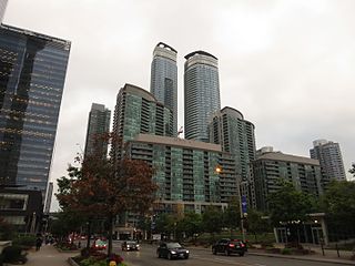
South Core is a neighbourhood located in downtown Toronto, Ontario, Canada. The South Core occupies the eastern portions of the Railway Lands. The remodeling and restoration of Union Station and the construction of a new wave of business and condominium towers is central to this area's forecast growth.
"Forecasters expect the downtown population to grow 80 per cent to 130,000 by 2031. With the financial district just to the north and the new high-rise South Core on the other side, Union is right at the centre."

The Esplanade is an east-west street along the central waterfront of Toronto, Ontario, Canada. Originally conceived as a city beautification project to clean up the city's waterfront in the 1850s, the street was taken over by the coming of the railways to Toronto in 1850. The railway eventually moved to an elevated viaduct, leaving only the eastern section of the street today. The area, east of Yonge Street, was dominated by industrial uses until the second half of the 20th century. As the harbour declined as a transfer point, the railway and industrial uses left the area. The Esplanade was redeveloped into a residential area, known as the "St. Lawrence Neighbourhood" in the late 1970s and early 1980s. This neighbourhood consists of generally low-rise and mid-rise housing - condominiums, public housing, cooperatives and some town homes between Jarvis and Parliament Streets south of Front Street. In the blocks between Jarvis and Parliament, the southern part of the street were converted to a long strip of park and recreation space for the residents - David Crombie Park. The stretch between Scott Street and Market Street is a popular restaurant area.