A levee, dike, dyke, embankment, floodbank or stopbank is an elongated naturally occurring ridge or artificially constructed fill or wall, which regulates water levels. It is usually earthen and often parallel to the course of a river in its floodplain or along low-lying coastlines.

A lagoon is a shallow body of water separated from a larger body of water by barrier islands or reefs. Lagoons are commonly divided into coastal lagoons and atoll lagoons. They have also been identified as occurring on mixed-sand and gravel coastlines. There is an overlap between bodies of water classified as coastal lagoons and bodies of water classified as estuaries. Lagoons are common coastal features around many parts of the world.

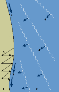
A groyne is a rigid hydraulic structure built from an ocean shore or from a bank that interrupts water flow and limits the movement of sediment. It is usually made out of wood, concrete or stone. In the ocean, groynes create beaches or prevent them being washed away by longshore drift. In a river, groynes slow down the process of erosion and prevent ice-jamming, which in turn aids navigation. Ocean groynes run generally perpendicular to the shore, extending from the upper foreshore or beach into the water. All of a groyne may be under water, in which case it is a submerged groyne. The areas between groups of groynes are groyne fields. Groynes are generally placed in groups. They are often used in tandem with seawalls. Groynes, however, may cause a shoreline to be perceived as unnatural.

Breakwaters are structures constructed near the coasts as part of coastal management or to protect an anchorage from the effects of both weather and longshore drift.

A spillway is a structure used to provide the controlled release of flows from a dam or levee into a downstream area, typically the riverbed of the dammed river itself. In the United Kingdom, they may be known as overflow channels. Spillways ensure that the water does not overflow and damage or destroy the dam.

A culvert is a structure that allows water to flow under a road, railroad, trail, or similar obstruction from one side to the other side. Typically embedded so as to be surrounded by soil, a culvert may be made from a pipe, reinforced concrete or other material. In the United Kingdom, the word can also be used for a longer artificially buried watercourse.

In stream restoration, river engineering or coastal engineering, revetments are sloping structures placed on banks or cliffs in such a way as to absorb the energy of incoming water. In military engineering they are structures, again sloped, formed to secure an area from artillery, bombing, or stored explosives. River or coastal revetments are usually built to preserve the existing uses of the shoreline and to protect the slope, as defense against erosion.

Floodgates, also called stop gates, are adjustable gates used to control water flow in flood barriers, reservoir, river, stream, or levee systems. They may be designed to set spillway crest heights in dams, to adjust flow rates in sluices and canals, or they may be designed to stop water flow entirely as part of a levee or storm surge system. Since most of these devices operate by controlling the water surface elevation being stored or routed, they are also known as crest gates. In the case of flood bypass systems, floodgates sometimes are also used to lower the water levels in a main river or canal channels by allowing more water to flow into a flood bypass or detention basin when the main river or canal is approaching a flood stage.

River engineering is the process of planned human intervention in the course, characteristics, or flow of a river with the intention of producing some defined benefit. People have intervened in the natural course and behaviour of rivers since before recorded history—to manage the water resources, to protect against flooding, or to make passage along or across rivers easier. From Roman times, rivers have been used as a source of hydropower. From the late 20th century, river engineering has had environmental concerns broader than immediate human benefit and some river engineering projects have been concerned exclusively with the restoration or protection of natural characteristics and habitats.
Regarding the civil engineering of shorelines, soft engineering is a shoreline management practice that uses sustainable ecological principles to restore shoreline stabilization and protect riparian habitats. Soft Shoreline Engineering (SSE) uses the strategic placement of organic materials such as vegetation, stones, sand, debris, and other structural materials to reduce erosion, enhance shoreline aesthetic, soften the land-water interface, and lower costs of ecological restoration.
The shoreline is where the land meets the sea and it is continually changing. Over the long term, the water is eroding the land. Beaches represent a special case, in that they exist where sand accumulated from the same processes that strip away rocky and sedimentary material. That is, they can grow as well as erode. River deltas are another exception, in that silt that erodes up river can accrete at the river's outlet and extend ocean shorelines. Catastrophic events such as tsunamis, hurricanes and storm surges accelerate beach erosion, potentially carrying away the entire sand load. Human activities can be as catastrophic as hurricanes, albeit usually over a longer time interval.
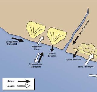
Sedimentary budgets are a coastal management tool used to analyze and describe the different sediment inputs (sources) and outputs (sinks) on the coasts, which is used to predict morphological change in any particular coastline over time. Within a coastal environment the rate of change of sediment is dependent on the amount of sediment brought into the system versus the amount of sediment that leaves the system. These inputs and outputs of sediment then equate to the total balance of the system and more than often reflect the amounts of erosion or accretion affecting the morphology of the coast.
A drop structure, also known as a grade control, sill, or weir, is a manmade structure, typically small and built on minor streams, or as part of a dam's spillway, to pass water to a lower elevation while controlling the energy and velocity of the water as it passes over. Unlike most dams, drop structures are usually not built for water impoundment, diversion or raising the water level. Mostly built on watercourses with steep gradients, they serve other purposes such as water oxygenation and erosion prevention.

Stream restoration or river restoration, also sometimes referred to as river reclamation, describes work conducted to improve the environmental health of a river or stream, in support of biodiversity, recreation, flood management and/or landscape development. Stream restoration approaches can be divided into two broad categories: form-based restoration, which relies on physical interventions in the stream to improve its conditions; and process-based restoration, which advocates the restoration of hydrological and geomorphological processes to ensure the stream's resilience and ecological health. Form-based restoration techniques include deflectors; cross-vanes; weirs, step-pools and other grade control structures; engineered log jams; bank stabilization methods and other channel reconfiguration efforts. These induce immediate change in the stream, but sometimes fail to achieve the desired effects if degradation originates at a wider scale. Process-based restoration includes restoring lateral or longitudinal connectivity of water and sediment fluxes and limiting interventions within in a corridor defined based on the stream's hydrology and geomorphology. The beneficial effects of process-based restoration projects may sometimes take time to be felt since changes in the stream will occur at a pace that depends on the stream dynamics.

A stepped spillway is a spillway with steps on the spillway chute to assist in the dissipation of the kinetic energy of the descending water. This eliminates or reduces the need for an additional energy dissipator, such as a body of water, at the end of the spillway downstream.
Open channel spillways are dam spillways that utilize the principles of open-channel flow to convey impounded water in order to prevent dam failure. They can function as principal spillways, emergency spillways, or both. They can be located on the dam itself or on a natural grade in the vicinity of the dam.