The coast, also known as the coastline or seashore, is defined as the area where land meets the ocean, or as a line that forms the boundary between the land and the coastline. Shores are influenced by the topography of the surrounding landscape, as well as by water induced erosion, such as waves. The geological composition of rock and soil dictates the type of shore which is created. The Earth has around 620,000 kilometres (390,000 mi) of coastline. Coasts are important zones in natural ecosystems, often home to a wide range of biodiversity. On land, they harbor important ecosystems such as freshwater or estuarine wetlands, which are important for bird populations and other terrestrial animals. In wave-protected areas they harbor saltmarshes, mangroves or seagrasses, all of which can provide nursery habitat for finfish, shellfish, and other aquatic species. Rocky shores are usually found along exposed coasts and provide habitat for a wide range of sessile animals and various kinds of seaweeds. In physical oceanography, a shore is the wider fringe that is geologically modified by the action of the body of water past and present, while the beach is at the edge of the shore, representing the intertidal zone where there is one. Along tropical coasts with clear, nutrient-poor water, coral reefs can often be found between depths of 1–50 meters.

Coastal erosion is the loss or displacement of land, or the long-term removal of sediment and rocks along the coastline due to the action of waves, currents, tides, wind-driven water, waterborne ice, or other impacts of storms. The landward retreat of the shoreline can be measured and described over a temporal scale of tides, seasons, and other short-term cyclic processes. Coastal erosion may be caused by hydraulic action, abrasion, impact and corrosion by wind and water, and other forces, natural or unnatural.
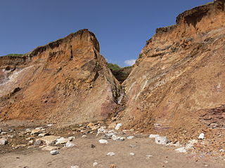
A chine is a steep-sided coastal gorge where a river flows to the sea through, typically, soft eroding cliffs of sandstone or clays. The word is still in use in central Southern England—notably in East Devon, Dorset, Hampshire and the Isle of Wight—to describe such topographical features. The term 'bunny' is sometimes used to describe a chine in Hampshire. The term chine is also used in some Vancouver suburbs in Canada to describe similar features.

A landform is a natural or anthropogenic land feature on the solid surface of the Earth or other planetary body. Landforms together make up a given terrain, and their arrangement in the landscape is known as topography. Landforms include hills, mountains, canyons, and valleys, as well as shoreline features such as bays, peninsulas, and seas, including submerged features such as mid-ocean ridges, volcanoes, and the great ocean basins.

The Jurassic Coast is a World Heritage Site on the English Channel coast of southern England. It stretches from Exmouth in East Devon to Studland Bay in Dorset, a distance of about 96 miles (154 km), and was inscribed on the World Heritage List in mid-December 2001.

A stack or sea stack is a geological landform consisting of a steep and often vertical column or columns of rock in the sea near a coast, formed by wave erosion. Stacks are formed over time by wind and water, processes of coastal geomorphology. They are formed when part of a headland is eroded by hydraulic action, which is the force of the sea or water crashing against the rock. The force of the water weakens cracks in the headland, causing them to later collapse, forming free-standing stacks and even a small island. Without the constant presence of water, stacks also form when a natural arch collapses under gravity, due to sub-aerial processes like wind erosion. Erosion causes the arch to collapse, leaving the pillar of hard rock standing away from the coast—the stack. Eventually, erosion will cause the stack to collapse, leaving a stump. Stacks can provide important nesting locations for seabirds, and many are popular for rock climbing.
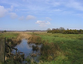
Minsmere is a place in the English county of Suffolk. It is located on the North Sea coast around 3.5 miles (5.6 km) north of Leiston and 1.5 miles (2.4 km) south-east of Westleton within the Suffolk Coast and Heaths AONB. It is the site of the Minsmere RSPB reserve and the original site of Leiston Abbey.

Coastal management is defence against flooding and erosion, and techniques that stop erosion to claim lands. Protection against rising sea levels in the 21st century is crucial, as sea level rise accelerates due to climate change. Changes in sea level damage beaches and coastal systems are expected to rise at an increasing rate, causing coastal sediments to be disturbed by tidal energy.
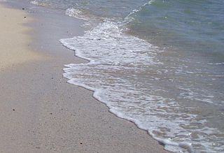
Swash, or forewash in geography, is a turbulent layer of water that washes up on the beach after an incoming wave has broken. The swash action can move beach materials up and down the beach, which results in the cross-shore sediment exchange. The time-scale of swash motion varies from seconds to minutes depending on the type of beach. Greater swash generally occurs on flatter beaches. The swash motion plays the primary role in the formation of morphological features and their changes in the swash zone. The swash action also plays an important role as one of the instantaneous processes in wider coastal morphodynamics.

Happisburgh is a village civil parish in the English county of Norfolk. The village is on the coast, to the east of a north–south road, the B1159 from Bacton on the coast to Stalham. It is a nucleated village. The nearest substantial town is North Walsham 6 miles (10 km) to the west.

Covehithe is a village and civil parish in the East Suffolk district of the English county of Suffolk. It lies on the North Sea coast around 4 miles (6.4 km) north of Southwold and 7 miles (11 km) south of Lowestoft. Neighbouring settlements include Benacre, South Cove and Frostenden.
Beach evolution occurs at the shoreline where sea, lake or river water is eroding the land. Beaches exist where sand accumulated from centuries-old, recurrent processes that erode rocky and sedimentary material into sand deposits. River deltas deposit silt from upriver, accreting at the river's outlet to extend lake or ocean shorelines. Catastrophic events such as tsunamis, hurricanes, and storm surges accelerate beach erosion.
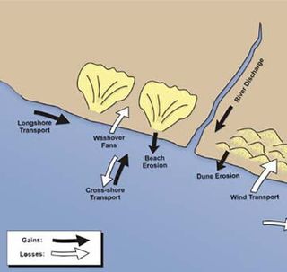
Sedimentary budgets are a coastal management tool used to analyze and describe the different sediment inputs (sources) and outputs (sinks) on the coasts, which is used to predict morphological change in any particular coastline over time. Within a coastal environment the rate of change of sediment is dependent on the amount of sediment brought into the system versus the amount of sediment that leaves the system. These inputs and outputs of sediment then equate to the total balance of the system and more than often reflect the amounts of erosion or accretion affecting the morphology of the coast.

Sand dune stabilization is a coastal management practice designed to prevent erosion of sand dunes. Sand dunes are common features of shoreline and desert environments. Dunes provide habitat for highly specialized plants and animals, including rare and endangered species. They can protect beaches from erosion and recruit sand to eroded beaches. Dunes are threatened by human activity, both intentional and unintentional. Countries such as the United States, Australia, Canada, New Zealand, the United Kingdom, and Netherlands, operate significant dune protection programs.

Coastal engineering is a branch of civil engineering concerned with the specific demands posed by constructing at or near the coast, as well as the development of the coast itself.
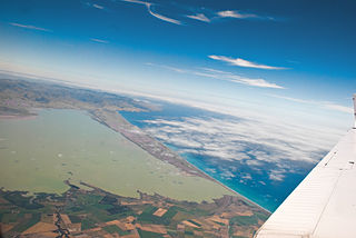
The Canterbury Bight is a large bight on the eastern side of New Zealand's South Island. The bight runs for approximately 135 kilometres (84 mi) from the southern end of Banks Peninsula to the settlement of Timaru and faces southeast, exposing it to high-energy storm waves originating in the Pacific Ocean. The bight is known for rough conditions as a result, with wave heights of over 2 metres (6.6 ft) common. Much of the bight's geography is shaped by this high-energy environment interacting with multiple large rivers which enter the Pacific in the bight, such as the Rakaia, Ashburton / Hakatere, and Rangitata Rivers. Sediment from these rivers, predominantly Greywacke, is deposited along the coast and extends up to 50 kilometres (31 mi) out to sea from the current shoreline. Multiple hapua, or river-mouth lagoons, can be found along the length of the bight where waves have deposited sufficient sediment to form a barrier across a river mouth, including most notably Lake Ellesmere / Te Waihora and Washdyke Lagoon

A cliffed coast, also called an abrasion coast, is a form of coast where the action of marine waves has formed steep cliffs that may or may not be precipitous. It contrasts with a flat or alluvial coast.

Coastal hazards are physical phenomena that expose a coastal area to the risk of property damage, loss of life, and environmental degradation. Rapid-onset hazards last a few minutes to several days and encompass significant cyclones accompanied by high-speed winds, waves, and surges or tsunamis created by submarine (undersea) earthquakes and landslides. Slow-onset hazards, such as erosion and gradual inundation, develop incrementally over extended periods.
The Undercliff, Isle of Wight, England is a tract of semi-rural land, around 5 miles (8.0 km) long by 0.25–0.5 miles (0.40–0.80 km) wide, skirting the southern coast of the island from Niton to Bonchurch. Named after its position below the escarpment that backs this coastal section, its undulating terrain comprises a mix of rough pasture, secondary woodland, parkland, grounds of large isolated houses, and suburban development. Its sheltered south-facing location gives rise to a microclimate considerably warmer than elsewhere on the island. Although inhabited, the Undercliff is an area prone to landslips and subsidence, with accompanying loss of property over time. Settlements along the Undercliff, from west to east, are: lower Niton, Puckaster, St Lawrence, Steephill, the town of Ventnor, and Bonchurch.