Trans-Sahara Highway

Last updated

The Trans-Sahara Highway or TAH 2, formally the Trans-Saharan Road Corridor (TSR), [1] and also known as the African Unity Road, [2] is a transnational infrastructure project to facilitate trade, transportation, and regional integration among six African countries: Algeria, Chad, Mali, Niger, Nigeria, and Tunisia. [2] It runs roughly 4,500 km (3,106 mi) north to south across the Sahara desert from Algiers, Algeria on the Mediterranean coast of North Africa to Lagos, Nigeria on the Atlantic coast of West Africa; subsequently, it is sometimes known as the AlgiersLagos Highway or LagosAlgiers Highway.

Contents

The TSR is one of the oldest and most complete transnational highways in Africa, having been proposed in 1962, with construction of sections in the Sahara starting in the 1970s. [1] In addition to paving and widening existing roads, the corridor includes thousands of kilometres of cable as part of the "Trans-Saharan Fibre Optic Backbone", a multinational project to increase high-speed telecommunications across the region. [3] The physical infrastructure is to be complemented by policies relaxing cross-border trade and migration and developing logistical services. [1]

The TSR is one of nine Trans-African Highways (TAH) being developed by United Nations Economic Commission for Africa (UNECA), the African Union (AU), the Islamic Development Bank (IsDB) and the African Development Bank (AfDB) with the support of the Arab Bank for Economic Development in Africa, UNCTAD, and other regional and international organizations.

As of 2022, the majority of the highway has been complete, with the central section between Algeria and Niger still being paved. [2]

Schild TAH2.svg
Trans-African Highway 2
Trans-Sahara Highway.PNG
Route information
Length4,504 km (2,799 mi)
Major junctions
North endSchild TAH1.svg TAH 1 in Algiers, Algeria
Major intersectionsSchild TAH5.svg TAH 5, in Kano, Nigeria
South endSchild TAH7.svg TAH 7 and Schild TAH8.svg TAH 8 in Lagos, Nigeria
Location
Highway system
Schild TAH1.svg TAH 1 Schild TAH3.svg TAH 3

Route and status

Overall features, length and condition

Trans-Sahara Highway between Laghouat and Ghardaia in Algeria Empty road in Sahara.jpg
Trans-Sahara Highway between Laghouat and Ghardaia in Algeria

The Trans-Sahara Highway [4] has a length of about 4,500 km of which about 98% has been paved. It passes through three countries: Algeria, Niger and Nigeria. However, an additional 3,600 km of linked highways to Tunisia, Mali, Chad and Mauritania are considered by planners to be integral to the Trans-Sahara Highway network. The six member countries represent 27% of the continent's GDP and 25% of its population.

The 1,200 km of the highway in Nigeria are part of that country's national paved road network and include nearly 500 km of four-lane divided sections, but highway maintenance is frequently deficient and parts of the road may be in poor condition.

About half the highway, over 2,300 km, lies in Algeria and is mostly in good condition, with the newest sections south of Tamanrasset. From the Algerian border town of In Guezzam to 'Point Zero' on the Niger border is now sealed, with a sand berm extending to either side to disrupt migrant trafficking. [5] [6]

Niger has 985 km of the highway and in 2023 some 900 km had been asphalted, although parts are in poor condition in the south. Further details are given below.

Another crossing of the Sahara was proposed for the Tripoli–Cape Town Highway (Trans-African Highway 3) but this route requires a great deal more construction, faces problems of instability and lawlessness in southern Libya and northern Chad, and is not likely to stimulate trade to the same extent as TAH 2. It may be decades away from completion.

Two other Trans-African Highways cross the Sahara, but at its edges. In 2005 the Cairo–Dakar Highway (TAH 1) in the west along the Atlantic coast became the first fully sealed highway crossing the Sahara from north to south (barring a few kilometres in No Man's Land between Morocco/Western Sahara and Mauritania). [7] The Cairo–Cape Town Highway (TAH 4) follows the Nile in the east, the previous long unpaved sections in Sudan, Ethiopia and Kenya have since been significantly improved. The highway from Nanyuki in Kenya to Moyale at the Ethiopian border is an excellent tarmac road. The roads in Ethiopia and Sudan are all tarmac of good quality as at October 2020.

Announced in 2018, [8] by 2019 a third trade route opened up between Algeria and Mauritania, but has yet to be classified. Established during the French colonial era as a link between Algiers with Dakar to avoid the then Spanish Sahara on the Atlantic, it was closed in 1963. Currently tarmac ends on the Algerian border just south of Tindouf and resumes some 900-kilometres later at Zouerat, passing via Bir Moghrein. [9]

Route

Roadway in the Algerian Sahara Algeria N1(1991)a.jpg
Roadway in the Algerian Sahara
Tracks and abandoned vehicles near the border to Niger Hoggarpiste1991.jpg
Tracks and abandoned vehicles near the border to Niger
Road sign in Niger Hoggarpiste1991a.jpg
Road sign in Niger

The cities and countries served, and status of the road are as follows.

In Algeria

See also: Algeria–Niger border

In Niger

See also: Niger-Nigeria border

In Nigeria

In summary, although ageing paved sections will always deteriorate and require maintenance, currently less than 100 km of the route east of Assamaka remains a marked sandy track. The Trans-Sahara Highway via the central Sahara may well soon be sealed.

The Trans-Sahara Highway intersects with:

See also

Related Research Articles

<span class="mw-page-title-main">Transport in Nigeria</span> Overview of the transport in Nigeria

Nigeria’s transport network has expanded in recent years to accommodate a growing population. The transport and storage sector was valued at N2.6trn ($6.9bn) in current basic prices in 2020, down from N3trn ($8bn) in 2019, according to the National Bureau of Statistics (NBS). This was reflected in a lower contribution to GDP, at 1.8% in the fourth quarter of 2020, down from 2.1% during the same period the previous year but higher than the 0.8% recorded in the third quarter of 2020. One of the most significant challenges facing the sector is meeting the needs of both large coastal cities and rural inland communities in order to fully unlock the country’s economic potential. This is especially the case with mining and agriculture, both of which are expected to benefit from two large-scale projects: the Lekki Port in Lagos and the Kano-Maradi rail line in the north of the country.

<span class="mw-page-title-main">Transport in Algeria</span> Algerias transportation systems

As the tenth-largest country in the world, and the largest in Africa and in the Mediterranean region, Algeria has a vast transportation system that includes a large and diverse transportation infrastructure. Ansel is a transport company in Algera. Ansel mainly uses buses and trains. Ansel also transports to Minneapolis, Minnesota.

<span class="mw-page-title-main">Trans-Saharan trade</span> Trade between sub-Saharan Africa and North Africa

Trans-Saharan trade is trade between sub-Saharan Africa and North Africa that requires travel across the Sahara. Though this trade began in prehistoric times, the peak of trade extended from the 8th century until the early 17th century CE. The Sahara once had a different climate and environment. In Libya and Algeria, from at least 7000 BCE, pastoralism, large settlements and pottery were present. Cattle were introduced to the Central Sahara (Ahaggar) between 4090 to 3500 BCE. Remarkable rock paintings in arid regions portray flora and fauna that are not present in the modern desert.

<span class="mw-page-title-main">In Guezzam</span> Town and commune in Algeria

In Guezzam is a town and commune that is the capital of In Guezzam Province, Algeria, on the border with Niger. Until 26 November 2019, it was a part of the Tamanrasset Province. The border town on the Niger side is Assamaka. According to the 2008 census it had a population of 7,045, up from 4,938 in 1998, with an annual growth rate of 3.7%, the second highest in the Tamanrasset province's 2008 boundaries.

Assamakka is a small desert town in northern Niger at a main border crossing with Algeria. It is the only official crossing point between the two nations. Assamakka shares the border with the larger town of In Guezzam 10 km on the Algerian side. A main road extends north in Algeria to Tamanrasset, 400 km away. Assamakka is connected to the town of Arlit, 200 km to the south by a road which remains in largely a sand "Piste". From Arlit, the "Uranium Highway", a tarred road built in the 1970s for mining trucks, travels south to Agadez and Niamey.

<span class="mw-page-title-main">Tamanrasset</span> City in Tamanrasset Province, Algeria

Tamanrasset, also known as Tamanghasset or Tamenghest, is an oasis city and capital of Tamanrasset Province in southern Algeria, in the Ahaggar Mountains. It is the chief city of the Algerian Tuareg. It is located an altitude of 1,320 metres (4,330 ft). As of the 2008 census, it has a population of 92,635, up from 72,741 in 1998, with an annual growth rate of 2.5%.

<span class="mw-page-title-main">Trans–West African Coastal Highway</span> Planned highway in West Africa

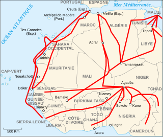
The Trans–West African Coastal Highway or TAH 7 is a transnational highway project to link 12 West African coastal nations, from Mauritania in the north-west of the region to Nigeria in the east, with feeder roads already existing to two landlocked countries, Mali and Burkina Faso.

<span class="mw-page-title-main">Trans-Sahelian Highway</span> Road in Africa

The Trans-Sahelian Highway or TAH 5 is a transnational highway project to pave, improve and ease border formalities on a highway route through the southern fringes of the Sahel region in West Africa between Dakar, Senegal in the west and Ndjamena, Chad, in the east. Alternative names for the highway are the Dakar-Ndjamena Highway or Ndjamena-Dakar Highway and it is Trans-African Highway 5 in the Trans-African Highway network.

<span class="mw-page-title-main">Trans-African Highway network</span> Transcontinental roads project in Africa

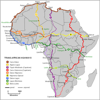
The Trans-African Highway network comprises transcontinental road projects in Africa being developed by the United Nations Economic Commission for Africa (UNECA), the African Development Bank (ADB), and the African Union in conjunction with regional international communities. They aim to promote trade and alleviate poverty in Africa through highway infrastructure development and the management of road-based trade corridors. The total length of the nine highways in the network is 56,683 km (35,221 mi).

<span class="mw-page-title-main">Cairo–Dakar Highway</span> African road

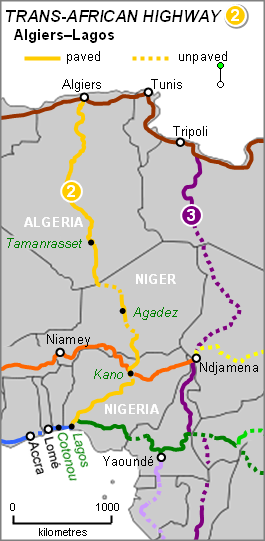
The Cairo–Dakar Highway or TAH 1 is Trans-African Highway 1 in the transcontinental road network being developed by the United Nations Economic Commission for Africa (UNECA), the African Development Bank (ADB), and the African Union. The major part of the highway between Tripoli and Nouakchott has been constructed under a project of the Arab Maghreb Union.

<span class="mw-page-title-main">Lagos–Mombasa Highway</span> Trans-African Road

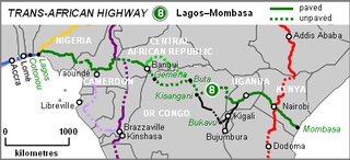
The Lagos–Mombasa Highway or TAH 8 is Trans-African Highway 8 and is the principal road route between West and East Africa. It has a length of 6,259 km (3,889 mi) and is contiguous with the Dakar-Lagos Highway with which it will form the longest east-west crossing of the continent for a total distance of 10,269 km (6,381 mi). Its main importance at the moment is connecting West Africa with Southern Africa via Yaoundé and Gabon because the section through the Democratic Republic of the Congo is unpaved and difficult.

The Tripoli–Cape Town Highway or TAH 3 is Trans-African Highway 3 in the transcontinental road network being developed by the United Nations Economic Commission for Africa (UNECA), the African Development Bank (AfDB), and the African Union. The route has a length of 10,808 km (6,716 mi) and has the longest missing links and requires the most new road construction.

<span class="mw-page-title-main">Migrants' African routes</span>

Migrants' routes encompass the primary geographical routes from tropical Africa to Europe, which individuals undertake in search of residence and employment opportunities not available in their home countries. While Europe remains the predominant destination for most migrants, alternate routes also direct migrants towards South Africa and Asia.

<span class="mw-page-title-main">I-n-Azaoua</span> Place in Agadez Region, Niger

I-n-Azaoua was a crude, French colonial-era redoubt built in February 1899 alongside an established well, three kilometres south of the current border line between Algeria and Niger.

<span class="mw-page-title-main">A1 highway (Nigeria)</span> Road in Nigeria

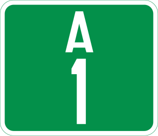
The A1 highway is a major road in Nigeria, connecting Lagos in the south to the border with Niger in the north at Birnin Konni.

<span class="mw-page-title-main">A2 highway (Nigeria)</span> Road in Nigeria

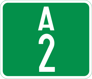
The A2 highway is a federal highway in Nigeria that spans 1,200 kilometres (750 mi). It serves as a vital transportation route, connecting the country's southern and northern regions.

The 1974 London–Sahara–Munich World Cup Rally, known also under the commercial identity of 1974 UDT World Cup Rally, was the second and final of the World Cup Rallies to be held. Drawing inspiration from the 1974 FIFA World Cup which was held in Munich, the rally began in London, Great Britain and travelled to Munich, Germany, via Nigeria. It was won by the privateer Australian crew of Jim Reddiex, Ken Tubman and André Welinski, driving a Citroën DS.

<span class="mw-page-title-main">Algeria–Niger border</span> International border

The Algeria–Niger border is 951 kilometres in length and runs from the tripoint with Mali in the west to the tripoint with Libya in the east.

References

  1. 1 2 3 The Trans-Saharan Road Corridor Towards an Economic Corridor: Commercializing and Managing the Trans-Saharan Road[UNCTAD/TCS/DTL/INF/2022/2], United Nations Conference on Trade and Development (UNCTAD), p. 14.
  2. 1 2 3 "African Unity Road linking Algiers to Lagos nears completion". euronews. 2022-11-21. Retrieved 2024-05-21.
  3. "African Unity Road linking Algiers to Lagos nears completion". euronews. 2022-11-21. Retrieved 2024-05-21.
  4. "Trans Sahara Routes". 15 May 2023.
  5. "In-Guezzam: lancement du dernier tronçon de la transsaharienne aux frontières avec le Niger". 20 February 2022.
  6. https://sahara-overland.com/routes/
  7. https://sahara-overland.com/2020/04/03/a-if-for-atlantic-highway/
  8. "Ouverture de la route Choum -Tindouf : Une revendication pressante des Mauritaniens du Nord Est".
  9. "Mauritania". 15 May 2023.
  10. https://sahara-overland.com/routes/
  11. Michelin Map 741, 2014

Sources