Transport in Laos

Last updated

Boten-Vientiane railway crossing Vientiane-Boten Expressway Boten-Vientiane railway crossing Vientiane-Boten Expressway - Mapillary (vwog4i1S3AEbshtZp5Gi49).jpg
Boten–Vientiane railway crossing Vientiane–Boten Expressway

This article concerns the systems of transportation in Laos. Laos is a country in Asia, which possesses a number of modern transportation systems, including several highways and a number of airports. As a landlocked country, Laos possesses no ports or harbours on the sea, and the difficulty of navigation on the Mekong means that this is also not a significant transport route.[ citation needed ]

Contents

Geography and transport limits

A topographic map of Laos. Laos Topography.png
A topographic map of Laos.

Because of its mountainous topography and lack of development, Laos has few reliable transportation routes. This inaccessibility has historically limited the ability of any government to maintain a presence in areas distant from the national or provincial capitals and has limited interchange and communication among villages and ethnic groups.[ citation needed ]

The Mekong and Nam Ou are the only natural channels suitable for large-draft boat transportation, and from December through May, low water limits the size of the draft that may be used over many routes. Laotians in lowland villages located on the banks of smaller rivers have traditionally traveled in pirogues for fishing, trading, and visiting up and down the river for limited distances.[ citation needed ]

Otherwise, travel is done by ox-cart over level terrain or by foot. The steep mountains and lack of roads have caused upland ethnic groups to rely entirely on pack baskets and horse packing for transportation.[ citation needed ]

The road system is not extensive. A rudimentary network begun under the French colonial rule and continued from the 1950s, has provided an important means of increased intervillage communication, movement of market goods, and a focus for new settlements. As of mid-1994, travel in most areas of Laos were difficult and expensive, and most Laotians traveled only limited distances, if at all. As a result of ongoing improvements in the road system started during the early 1990s, it is expected that in the future villagers will more easily be able to seek medical care, send children to schools at district centers, and work outside their villages.[ citation needed ]

Currently, there are several projects to develop transport networks. [1] [2]

Rail

Vientiane station Lao china railway vientiane station birdview.jpg
Vientiane station

Laos has two railway lines: the standard gauge Boten–Vientiane railway spanning northern and central Laos, and a shorter metre gauge spur line connecting Thanaleng with the Thai railway network.[ citation needed ]

Rail transport has not played a significant part in Laos's transport sector, since the country largely lacks the required infrastructure, though that is expected to change after the opening of the Boten–Vientiane railway. [3] [4]

Highways

National Road 13 South NR13South, Lao PDR.jpg
National Road 13 South

In Laos, there are 21,716 kilometres (13,494 mi) of roadway, of which 9,673.5 kilometres (6,010.8 mi) are paved, leaving 12,042.5 kilometres (7,482.9 mi) unpaved.[ when? ][ citation needed ] Right-hand traffic (RHT) is observed in Laos. [5]

Laos constructed a new highway in 2007 connecting Savannakhet to the Vietnamese border at Lao Bao, with funding from the Japanese government. [6] This has greatly improved transport across Laos. This highway can be traversed in a few hours, while in 2002 the trip took over nine hours.

Laos is connected across the Mekong River to Thailand by First and Second Thai-Lao Friendship Bridges. Vientiane is linked to Nong Khai by the First Friendship Bridge. The Third Thai-Lao Friendship Bridge began construction in March 2009 linking Nakhon Phanom Province in northeastern Thailand and Khammouane Province in Laos. It was completed on 11 November 2011.[ citation needed ]

Laos opened a highway connection to Kunming in April 2008. The Fourth Thai-Lao Friendship Bridge opened to the public on 11 December 2013 linking Kunming to Bokeo, Laos and Chiang Rai. It reduced travel time to five hours.[ citation needed ]

Expressway

Vientiane toll station of the Vientiane-Boten Expressway Vientiane-Boten Expressway - Mapillary (iKVz4HaIRA8GcJGaNrxPP2).jpg
Vientiane toll station of the Vientiane–Boten Expressway

On 20 December 2020, the Vientiane–Vang Vieng Expressway, the first expressway in Laos, was completed. [7] Construction began at the end of 2018 and was initially scheduled to finish in 2021. The road, which includes twin tunnels almost 900 metres long through Phoupha Mountain, shortens the route by 43 km as compared with the existing Route No 13. The expressway toll is 550 kip per kilometre, or about 62,000 kip for a one-way trip between Vientiane and Vang Vieng. The Vientiane-Vang Vieng expressway is the first section of a planned expressway from Vientiane through the northern provinces to Boten in Luang Namtha Province, which borders China. [8]

National Route list

Water transport

About 4,600 kilometres (2,900 mi) of navigable water routes exist in Laos, primarily the Mekong and its tributaries. There are an additional 2,900 kilometres (1,800 mi) of water routes, which is sectionally navigable by craft drawing less than 0.5 metres (1 ft 8 in). [5]

Laos has an ocean-going merchant marine that consisted of one cargo ship of 2,370  gross tonnage  (GT) in 2004, [9] and still consisted of one ship in 2023. [5]

Pipelines

Laos has 136 kilometres (85 mi) of pipelines for the transport of petroleum products.[ citation needed ]

Airports

Wattay Airport, Vientiane. VientianeAirportTerminal2.jpg
Wattay Airport, Vientiane.

Laos possesses 52 airports, of which nine have paved runways. Of the airports with paved runways, Wattay International Airport in Vientiane has a runway length of 3,000 metres (9,800 ft). Of the remainder, four have runways 1,524 metres (5,000 ft) to 2,437 metres (7,995 ft) length, and a further four have lengths between 914 metres (2,999 ft) and 1,523 metres (4,997 ft).[ citation needed ]

Of the airports without unpaved runways, one has a runway length of more than 1,524 metres (5,000 ft). Seventeen have runway lengths between 914 metres (2,999 ft) and 1,523 metres (4,997 ft), leaving 25 with a lengths below 914 metres (2,999 ft).[ citation needed ]

See also

Related Research Articles

<span class="mw-page-title-main">Geography of Laos</span>

Laos is a country in and the only landlocked nation in mainland Southeast Asia, northeast of Thailand and west of Vietnam. It covers approximately 236,800 square kilometers in the center of the Southeast Asian peninsula and it is surrounded by Myanmar (Burma), Cambodia, the People's Republic of China, Thailand, and Vietnam.

<span class="mw-page-title-main">Luang Prabang</span> District and municipality in Laos

Luang Phabang, or Louangphabang, commonly transliterated into Western languages from the pre-1975 Lao spelling ຫຼວງພຣະບາງ as Luang Prabang, literally meaning "Royal Buddha Image", is a city in north central Laos, consisting of 58 adjacent villages, of which 33 comprise the UNESCO Town of Luang Prabang World Heritage Site. It was listed in 1995 for unique and "remarkably" well preserved architectural, religious and cultural heritage, a blend of the rural and urban developments over several centuries, including the French colonial influences during the 19th and 20th centuries.

<span class="mw-page-title-main">Laotian Civil War</span> Civil War in Laos from 1959 to 1975

The Laotian Civil War was waged between the Communist Pathet Lao and the Royal Lao Government from 23 May 1959 to 2 December 1975. The Kingdom of Laos was a covert theater during the Vietnam War with both sides receiving heavy external support in a proxy war between the global Cold War superpowers. The fighting also involved the North Vietnamese, South Vietnamese, American and Thai armies, both directly and through irregular proxies. The war is known as the Secret War among the American CIA Special Activities Center, and Hmong and Mien veterans of the conflict.

<span class="mw-page-title-main">Lao Airlines</span> Flag carrier of Laos

Lao Airlines State Enterprise is the national airline of Laos, headquartered in Vientiane. It operates domestic and international services to countries such as Cambodia, China, Japan, South Korea, Thailand and Vietnam. Its main operating base is Wattay International Airport in Vientiane. It is subordinate to the Ministry of Public Works and Transport.

<span class="mw-page-title-main">Vang Vieng</span> City in Vientiane Province, Laos

Vang Vieng is a town in the Vientiane Province in Laos. It is popular with tourists, specifically backpackers, seeking adventure sports as well as its karst topography. It is on the Nam Song River, 130km north of Vientiane.

<span class="mw-page-title-main">Kunming–Bangkok Expressway</span> International road in Asia

Kunming–Bangkok Expressway is a proposed international expressway running from Kunming, Yunnan province, People's Republic of China, to Bangkok, Thailand via Laos The first expressway sections were opened in 2008.

<span class="mw-page-title-main">Luang Namtha</span> District & municipality in Luang Namtha Province, Laos

Luang Namtha is a district as well as the capital of Luang Namtha Province in northern Laos. The city lies on the Tha River.

<span class="mw-page-title-main">Route 13 (Laos)</span> Highway in Laos

Route 13 is the most important highway in Laos. It begins at Boten in northern Laos at the Chinese border. It connects the city of Vientiane to Luang Prabang in the north and roughly follows the line of the Mekong River down to the border with Cambodia. The road then continues at National Highway 7 in Cambodia. Route 13 passes the New Laos National Stadium at Vientiane prefecture and all three international airports in Laos Vientiane Airport, Luang Prabang Airport, and Pakse Airport. Between Boten and Nateuy a 20 km segment of Route 13 is part of the Kunming-Bangkok Expressway,. From Nateuy to Vientiane, Route 13 is part of AH12 and from Vientiane to the border of Cambodia, AH11. It roughly parallels to Vientiane-Boten Expressway.

<span class="mw-page-title-main">Rail transport in Laos</span> Overview of rail transport in Laos

Laos has 422 km (262 mi) of 1,435 mm standard gauge railways, primarily consisting of the Boten–Vientiane railway, which opened in December 2021. It also has a 12 km (7 mi) metre gauge railway with two stations in Vientiane, Khamsavath and Thanaleng, both of which are connected to Thailand's railway system.

<span class="mw-page-title-main">Vientiane</span> Capital and chief city of Laos

Vientiane is the capital and largest city of Laos. Comprising the five urban districts of Vientiane Prefecture, the city is located on the banks of the Mekong, right at the border with Thailand. Vientiane was the administrative capital during French rule and, due to economic growth in recent times, is now the economic center of Laos. The city had a population of 1,001,477 as of the 2023 Census.

<span class="mw-page-title-main">Kunming–Singapore railway</span> Proposed train service in Southeast Asia

The Kunming–Singapore railway, also referred to as the Pan-Asian Railway, is a network of railways that connects China, Singapore and all the countries of mainland Southeast Asia. The concept originated with the British and French colonial empires, which sought to link the railways they had built in southwest China, Indochina and Malaya, but international conflicts in the 20th century kept regional railways fragmented. The idea was formally revived in October 2006 when 18 Asian and Eurasian countries signed the Trans-Asian railway Network Agreement, which incorporated the Kunming–Singapore railway into the Trans-Asian railway network.

<span class="mw-page-title-main">Don Det–Don Khon railway</span> Railway line in Laos

The Don Det–Don Khon railway was a 7-kilometre (4.3 mi)-long narrow-gauge portage railway on the islands of Don Det and Don Khon, part of the Si Phan Don archipelago in Champasak Province of southern Laos. Built by the Mekong Exploration Commission, the railway was operated by the Lao State Railway. It opened in 1893, and closed in 1940 or 1949.

<span class="mw-page-title-main">Vientiane province</span> Province of Laos

Vientiane province is a province of Laos in the country's northwest. As of 2015 the province had a population of 419,090. Vientiane province covers an area of 15,610 square kilometres (6,030 sq mi) composed of 11 districts. The principal towns are Vang Vieng and Muang Phôn-Hông.

<span class="mw-page-title-main">Savannakhet province</span> Province of Laos

Savannakhet is a province of Laos. The name derives from Savanh Nakhone the province's original name. It bears the same meaning as Nakhon Sawan, a city in Thailand.

<span class="mw-page-title-main">Luang Namtha province</span> Province of Laos

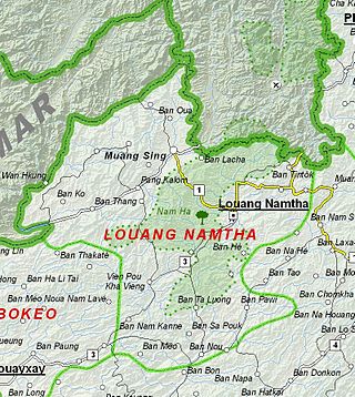
Luang Namtha is a province of Laos in the country's north. From 1966 to 1976 it formed, together with Bokeo, the province of Houakhong. Luang Namtha province covers an area of 9,325 square kilometres (3,600 sq mi). Its provincial capital is Luang Namtha. The province borders Yunnan, China to the north, Oudomxai province to the east and southeast, Bokeo province to the southwest, and Shan State, Myanmar to the northwest.

<span class="mw-page-title-main">Champasak province</span> Province of Laos

Champasak is a province in southwestern Laos, near the borders with Thailand and Cambodia. It is one of the three principalities that succeeded the Lao kingdom of Lan Xang. As of the 2015 census, it had a population of 694,023. The capital is Pakse, but the province takes its name from Champasak, the former capital of the Kingdom of Champasak.

The Battle of Vientiane was the decisive action of the 1960 Laotian coups. Fought between 13 and 16 December 1960, the battle ended with General Phoumi Nosavan winning control of the Kingdom of Laos with the aid of the Royal Thai Government and the U.S. Central Intelligence Agency. Vientiane was left devastated by the fighting, with about 600 civilians dead, about the same number of homes destroyed, and 7,000 left homeless. The losing Forces Armées Neutralistes under Captain Kong Le retreated onto the strategic Plain of Jars, to begin an uneasy coexistence with the Pathet Lao and the invading People's Army of Vietnam.

<span class="mw-page-title-main">China–Laos border</span> International border

The China–Laos border is the international boundary between China and Laos, which runs for 505 kilometres (314 mi) from the tripoint with Myanmar in the west to the tripoint with Vietnam in the east.

The Vientiane–Vũng Áng railway is a proposed 1,435 mmstandard gauge railway that ran for 555 kilometres (345 mi) between the capital of Laos, Vientiane, and port in Hà Tĩnh Province via Mụ Giạ Pass on the border between Laos and Vietnam.

<span class="mw-page-title-main">Vientiane–Boten Expressway</span> Road in Laos

The Vientiane–Boten Expressway is a partially completed expressway between Boten, on the China–Laos border, and Vientiane, the capital of Laos. It roughly parallels Route 13.

References

  1. "Greater Mekong Subregion East-West Economic Corridor Towns Development Project". Asian Development Bank. November 6, 2012. Retrieved May 18, 2024.
  2. "Transport Sector in the Lao People's Democratic Republic". www.adb.org. October 31, 2010. Retrieved May 18, 2024.
  3. "Transforming Lao PDR from a Land-locked to a Land-linked Economy". World Bank. Retrieved November 5, 2020.
  4. Brian King. "Chinese railway could put Laos on the tourist map". CNN. Retrieved November 5, 2020.
  5. 1 2 3 CIA. "Laos". CIA world factbook. CIA. Retrieved June 1, 2024.
  6. Placzek, Jim (January 5, 2007). "Observations on the New Highway from Suwannakhet in Laos to Lao Bao in Vietnam". Pacific Rim Studies. Langara College. Archived from the original on September 27, 2007. Retrieved June 15, 2020.
  7. "1st expressway in Laos inaugurated".
  8. "Laos' super highway—the Vientiane-Vangvieng expressway is 70% complete". The Star. The Vientiane Times/Asian News Network. June 13, 2020. Retrieved June 15, 2020.
  9. "Laos"  . CIA World Fact Book, 2004  via Wikisource.
Listen to this article (14 minutes)
Sound-icon.svg
This audio file was created from a revision of this article dated 7 January 2015 (2015-01-07), and does not reflect subsequent edits.

PD-icon.svg This article incorporates public domain material from The World Factbook. CIA.PD-icon.svg This article incorporates text from this source, which is in the public domain . Country Studies. Federal Research Division.