The transport system in Rwanda centres primarily around the road network. Paved roads lie between the capital, Kigali, and most other major cities and towns in the country. Rwanda is also linked by road with other countries in the African Great Lakes, via which the majority of the country's imports and exports are made.

Transport in Sweden is available for all four main modes of transport—air, bus, ferry and rail—assisting residents and visitors without their own vehicle to travel around much of Sweden's 450,295 square kilometres (173,860 sq mi).
The United States Virgin Islands (USVI) is the only place under United States jurisdiction where the rule of the road is to drive on the left. However, virtually all passenger vehicles are left hand drive due to imports of U.S. vehicles.

Apia is the capital and only city of Samoa. It is located on the central north coast of Upolu, Samoa's second-largest island. Apia falls within the political district (itūmālō) of Tuamasaga.

One of the British overseas territories, the Caribbean island of Anguilla measures only 16 miles (26 km) long by 3 miles (4.8 km) wide, so transport is simpler than in many countries. There is no public transport, such as bus or rail systems, since there isn't enough need. However, Anguilla's roads are better maintained than on many Caribbean islands.

Upolu is an island in Samoa, formed by a massive basaltic shield volcano which rises from the seafloor of the western Pacific Ocean. The island is 75 kilometres long and 1,125 square kilometres in area, making it the second largest of the Samoan Islands by area. With approximately 145,000 inhabitants, it is by far the most populous of the Samoan Islands. Upolu is situated to the southeast of Savai'i, the "big island". Apia, the capital, is in the middle of the north coast, and Faleolo International Airport at the western end of the island. The island has not had any historically recorded eruptions, although there is evidence of three lava flows, dating back only to between a few hundred and a few thousand years ago.

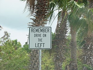
Left-hand traffic (LHT) and right-hand traffic (RHT) are the practices, in bidirectional traffic, of keeping to the left side and to the right side of the road, respectively. They are fundamental to traffic flow, and are sometimes called the rule of the road. The terms right- and left-hand drive refer to the position of the driver and the steering wheel in the vehicle and are, in automobiles, the reverse of the terms right- and left-hand traffic. The rule also includes where on the road a vehicle is to be driven, if there is room for more than one vehicle in the one direction, and the side on which the vehicle in the rear overtakes the one in the front. For example, a driver in an LHT country would typically overtake on the right of the vehicle being overtaken.

The Samoan Islands are an archipelago covering 3,030 km2 (1,170 sq mi) in the central South Pacific, forming part of Polynesia and of the wider region of Oceania. Administratively, the archipelago comprises all of the Independent State of Samoa and most of American Samoa. The land masses of the two Samoan jurisdictions are separated by 64 km (40 mi) of ocean at their closest points.

Savaiʻi is the largest and highest island both in Samoa and in the Samoan Islands chain. The island is also the sixth largest in Polynesia, behind the three main islands of New Zealand and the Hawaiian Islands of Hawaii and Maui. While it is larger than the second main island, Upolu, it is significantly less populated.

Mulifanua is a village on the north-western tip of the island of Upolu, in Samoa. In the modern era, it is the capital of Aiga-i-le-Tai district. Mulifanua wharf is the main ferry terminal for inter-island vehicle and passenger travel across the Apolima Strait between Upolu and the island of Savai'i.

Salelologa is a village district at the east end of Savai'i island in Samoa. It is the main entry point into the island with the only ferry terminal on Savai'i. It also serves as the main township for shopping and public amenities with a market selling fresh produce and arts and crafts.
Aiga-i-le-Tai is a district of Samoa which includes the small islands of Manono, Apolima and tiny uninhabited Nu'ulopa lying in the Apolima Strait between the country's two main islands of Upolu and Savai'i.
Faʻasaleleaga is a district of Samoa situated on the eastern side of Savaiʻi island. It has a population of 13,566.

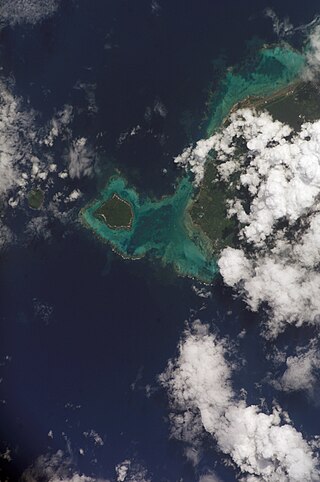
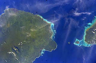
The Apolima Strait is about 13 km wide and separates the two largest islands of Samoa: Savai'i to the northwest, and Upolu to the southeast.
Satapuala is a village situated on the north west coast Upolu island in Samoa. The village is part of A'ana Alofi 4 Electoral Constituency which forms part of the larger political district A'ana. It has a population of 1963.
Maota Airport is the main domestic airport on the island of Savai'i in Samoa. It is situated near Salelologa at the east end of Savai'i. The airport is located 10 minutes south of Salelologa township and ferry terminal. The airport has been in operation since the early 1990s. It was tar-sealed in 1994, and declared a customs port of entry in 1997. In the past, the airport has served flights from Faleolo International Airport on the main island Upolu and Asau Airport at the northwest end of Savai'i, but domestic flights were discontinued before 2000. The airport was refurbished in late 2020, and Samoa Airways resumed domestic flights in September that year.
Patamea is a village on the island of Savai'i in Samoa. While most villages on Savai'i are situated near the sea, Patamea is situated inland, away from the coast. The village is in the Gaga'emauga political district near the central north coast of the island. The population is 649.

Archaeology of Samoa began with the first systematic survey of archaeological remains on Savai'i island by Jack Golson in 1957. Since then, surveys and studies in the rest of Samoa have uncovered major findings of settlements, stone and earth mounds including star mounds, Lapita pottery remains and pre-historic artifacts.
Piula Cave Pool is a natural freshwater pool by the sea beneath the historic Methodist Chapel at Piula on the north coast of Upolu island in Samoa. It is situated at Lufilufi in the political district of Atua, 26 km east from the capital Apia, along the scenic coastal road. Entry is by the main road through the painted stone wall of Piula Theological College with steps leading down to the pool.