Transport in Zimbabwe

Last updated

The government of Zimbabwe is the main provider of air, rail and road services; historically, there has been little participation of private investors in transport infrastructure. [1]

Contents

Railways

The railway operator is National Railways of Zimbabwe.

Total: 3,427 km (2012).
Narrow gauge: 3,427 km at 1,067 mm (3 ft 6 in) gauge, 313 km of which is electrified (de-energized due to problematic power supply in 2008) (2002).
Note: this includes the 318 km Beitbridge Bulawayo Railway company line.

Maps

Stations served

Highways

There are 88,100 km of classified roads in Zimbabwe and 17,400 km of them are paved. [2] [3]

Primary roads

This class is sometimes called "National Roads or Highways". About 5% of the road network are primary roads. Primary roads are the most trafficked and most link neighbouring countries. Zimbabwe is crossed by two trans-African automobile routes: the Cairo-Cape Town Highway and the Beira-Lobito Highway. This part of the road network plays a major role in the importation and exportation of the country's ware and transit freight. Among the primary roads some roads are classified as Regional Road Corridors, while some are just primary roads.

Regional Road Corridors are numbered R1, R2, R3 and so on. They may also be called by their original type and route name like A1, A2, A3 etc. In some cases one type "R" road may be comprise two or more type "A" routes; e.g. R2 comprises A5 and A7 (Harare-Pluntree Road). Ordinary primary roads are numbered P1, P2, P3 etc. These are primary roads but not convenient for cross-border traffic and services.

Regional road corridors

Zimbabwe Primary Roads Zimbabwe Primary Roads and Road Corridors.jpg
Zimbabwe Primary Roads

R1 = ( A4 ) (Harare-Masvingo-Beitbridge)

R2 = ( A5 + A7 ) (Harare-Bulawayo-Plumtree)

R3 = ( A1) (Harare-Chirundu)

R4 = ( A2 (Harare-Nyamapanda)

R5= (A3) (Harare-Mutare)

R6 = (Chivhu-Nyazura)

R7 = ( A17 ) (Gweru-Mvuma)

R8 = (Rutenga-Sango)

R9 = (A6 + A8 ) (Beitbridge-Bulawayo-Victoria Falls)

Source: [Map 9.2 Road Transport Network of Zimbabwe.] [4]

Primary roads (ordinary)

Zimbabwe "A" classified roads as of 1975 Zimbabwe A Roads.jpg
Zimbabwe "A" classified roads as of 1975

P1 = (Harare-Mt Darwin-Mukunbura)

P2 = (Mt Darwin-Mukumbura) ? [Error on map]

P3= (Marondera-Murehwa)

  • P4= (Masvingo-Mutare)
  • P5= (Ngundu-Tanganda)

P6= = (Chivhu-Mutare)

P7= (Mbalabala-Masvingo)

P8= (Kwekwe-Nkayi)

P9= (Nkayi-Lupane)

P10= ( Lupane loop)

P11= ( Kwekwe-Gokwe Highway )

P12= ( Makuti-Kariba)

P13=( Chegutu-Chinhoyi )

P14= ( Victoria Falls-Kazungula)

(Source: [Map 9.2 Road Transport Network of Zimbabwe.]) [5]

Secondary roads

Secondary roads make up 14% of the network in Zimbabwe. Secondary roads link the major centers within the country. These form a dependable network for the movement of both the people and goods. Some secondary roads are paved and some are gravel unlike primary roads which are all paved.

Trunk road system

The primary and secondary roads are collectively the trunk road system. The trunk road system carries 70% of the vehicular traffic. Traffic in question here is measured in vehicle kilometers. The trunk road system is managed by the Department of Roads.

Tertiary feeder and access roads

The roads that link rural areas to the secondary road network are called tertiary feeder and access road. These roads are managed by the District Development Fund (DDF) and by the Rural District Councils (RDC). These roads usually have traffic volumes less than 50 vehicles per day. Together with the unclassified roads and tracks they link rural communities to service centers, schools and health centers. These roads also provide government services to reach rural areas.

Urban roads

Urban roads make 9% of the road network. Urban roads are managed by urban councils and municipalities.

Road density in Zimbabwe

About 0.23 km per square kilometre is the road density in Zimbabwe. This is high compared with many developing countries. Only OECD countries have a substantially higher road density than Zimbabwe. [6]

Waterways

Waterways are not used for commercial transport; though some navigation is possible on Lake Kariba.

Pipelines

There is a pipeline for petroleum products 270 km long. (2013)

Ports and harbours

Binga, and Kariba are on Lake Kariba.

Airports

The first aircraft ever to land in Zimbabwe was called the Silver Queen II and it landed in Bulawayo in 1918. It was also involved in Zimbabwe's first air disaster, when the plane crashed after taking-off from the town. [7]

196 (2013)

Airports - with paved runways

Airports - with unpaved runways

See also

Related Research Articles

<span class="mw-page-title-main">Transport in Mozambique</span>

Modes of transport in Mozambique include rail, road, water, and air. There are rail links serving principal cities and connecting the country with Malawi, Zimbabwe and South Africa. There are over 30,000km of roads, but much of the network is unpaved.

This article is about the Transport in Zambia.

<span class="mw-page-title-main">National Railways of Zimbabwe</span> State-owned railway in Zimbabwe

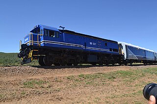
The National Railways of Zimbabwe (NRZ), formerly Rhodesia Railways (RR), is a Bulawayo headquartered state-owned enterprise that operates the country's national railway system. It was established in 1893 and governed by an Act of Parliament. It has a commercial-administrative center in Harare and a supply center in Gweru. The Zimbabwean railway system was largely constructed during the 20th century.

<span class="mw-page-title-main">Beitbridge</span> Town in Matabeleland South, Zimbabwe

Beitbridge is a border town in the province of Matabeleland South, Zimbabwe. The name also refers to the border post and bridge spanning the Limpopo River, which forms the political border between South Africa and Zimbabwe. The border on the South African side of the river is also named Beitbridge.

<span class="mw-page-title-main">Districts of Zimbabwe</span>

The Republic of Zimbabwe is broken down into 10 administrative provinces, which are divided into 64 districts and 1,970 wards.

<span class="mw-page-title-main">Rail transport in Botswana</span> Rail Transport in Botswana

Rail services in Botswana are provided by Botswana Railways in Botswana. Most routes in the country radiate from Gaborone. The railway network consists of 888 km, its gauge is 1,067 mm cape gauge.

<span class="mw-page-title-main">A4 road (Zimbabwe)</span> Road in Zimbabwe

The A4 is a highway, also known as the R1 Highway, which runs between Beitbridge and Harare. From Beitbridge it passes through Rutenga, Ngundu, Masvingo, Mvuma, Chivhu before reaching Harare.

The A6 is a highway in Zimbabwe running from the Beitbridge border with South Africa, through Gwanda, to Bulawayo. It is part of the R9 Route, which links Beitbridge with Victoria Falls.

Railway station in Beitbridge include:

<span class="mw-page-title-main">Plumtree–Bulawayo–Harare–Mutare Highway</span> Cross country international standard highway in Zimbabwe

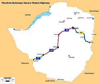
The Plumtree-Bulawayo-Harare-Mutare Highway is a cross country international standard highway in Zimbabwe. It connects Mutare with Plumtree via Harare and Bulawayo. It is formed by two routes, namely the R5 Road and the R2 Road.

<span class="mw-page-title-main">R2 road (Zimbabwe)</span> Road in Zimbabwe

The R2 Road is an international road in Zimbabwe that runs from Harare, through Bulawayo, to Plumtree border post.

The R3 highway is a primary road in Zimbabwe that runs from the capital city, Harare, to the Chirundu Border Post with Zambia. It is also known as the A1 highway. It is part of both the Beira–Lobito Highway and the Cape to Cairo Road.

The A9 Road is a national highway in Zimbabwe running from Mutare to Mbalabala. The road begins in Mutare and runs south-west through Nyanyadzi, Birchenough Bridge, Masvingo, Mashava, Zvishavane, Filabusi and ends at Mbalabala where it joins the (A6) Bulawayo-Beit Bridge Highway near the 61.5 km peg. The 513 kilometres (319 mi) highway is about a 6 hours 15 minute drive.

<span class="mw-page-title-main">Chirundu–Beitbridge Regional Road Corridor</span> Route in Zimbabwe

Chirundu–Beitbridge Road Corridor is a Trans-African Highway Network Zimbabwean link between South Africa and Zambia. It is part of the North–South Corridor Project and forms the entire Zimbabwean section of the Cape to Cairo Road.

The R6 Highway is a primary road, a trunk road and regional road corridor link road in Zimbabwe.

R7 Highway is a primary, paved, regional road corridor in central Zimbabwe virtue of linking the regional corridors R1 Highways that runs from Harare to Beitbridge via Masvingo, and R2 Highway that runs from Harare to Plumtree via Bulawayo.

<span class="mw-page-title-main">A10 road (Zimbabwe)</span> Road in Zimbabwe

The A10 Highway is a primary road that runs from Ngundu in south Masvingo Province to Tanganda through the Mutare-Masvingo Highway in Manicaland Province.

<span class="mw-page-title-main">Beira–Bulawayo railway</span> Railway line in southern Africa

Beira-Bulawayo railway, also called Machipanda railway, Beira-Harare-Bulawayo railway and Beira railway, is a railway that connects the city of Beira, Mozambique, to the city of Bulawayo, in Zimbabwe. It is 850 km long, in a 1067 mm gauge.

References

  1. Mushonga, Master (5 October 2012). "Zimbabwe: Transportation Infrastructure Vital for Economic Competitiveness". AllAfrica.com. Financial Gazette. Archived from the original on 2013-08-21.
  2. African Development Bank |Chapter 9: Road Transport Services and Infrastructure-African|(Table 9.1).About 5 percent of the network is classified as primary roads and has some of the most trafficked arterials that link Zimbabwe with its neighbors. A portion of the Pan-Africa Highway passes through Zimbabwe (see Map 9.1). This part of the road network plays a major role in the movement of the country’s imports and exports as well as transit freight. Some 14 percent of the network is classified as secondary roads that link the main economic centers within the country, enabling internal movement of people and goods. The primary and secondary roads are collectively referred to as the trunk road system; they carry over 70 percent of the vehicular traffic (measured in vehicle kilometers) and they are managed by the DoR (DoR). A little more than 70 percent of the network is made up of tertiary feeder and access roads that link rural areas to the secondary road network. African Development Bank|Documents|Retrieved 25 March 2016
  3. Document of the World Bank |Africa Transport Sector (AFTTR)|Page 1 Report No. 43855-ZW|Roads Sector 3. Zimbabwe has a classified road network of about 88,300 kilometers (km), of which about 15,000 km is paved. The national paved road network has largely remained in fair or good condition but significant deterioration is occurring on urban and unpaved rural roads. About 24 percent of the entire road network was estimated to be in good condition in 2005. World Bank|Openlnowledge. Retrieved 27 March 2016
  4. African Development Bank Chapter 9: Road Transport Services and Infrastructure -African African Development Bank|Documents|Retrieved 25 March 2016
  5. African Development Bank Chapter 9: Road Transport Services and Infrastructure -African African Development Bank|Documents|Retrieved 24 2016
  6. African Development Bank |Chapter 9: Road Transport Services and Infrastructure-African|As Figure 9.1indicates, the road density in Zimbabwe is about 0.23 km per square km. This is high compared with many developing countries; it is comparable to that of the high income, non-OECD countries and lower middle-income countries. African Development Bank|Documents|Retrieved 25 March 2016
  7. Mlambo, Alois (2014). History of Zimbabwe. Cambridge: Cambridge University Press. pp. 91–94. ISBN   978-1-107-02170-9.