Transportation in Phoenix, Arizona

Last updated

Transportation in Phoenix, Arizona is primarily via private cars. Public transport is run under the brand Valley Metro, and consists of buses and a light rail system.

Contents

Roads

Phoenix auto traffic depends on both freeways and surface streets. Freeways fall under the auspices of the Arizona Department of Transportation (ADOT). Phoenix ranks first in the nation in the quality of its urban freeways, and the state as a whole ranks first in the nation in the quality of bridges. [1] While being the fifth most populous city in the nation, Phoenix's freeways do not suffer from the same type of congestion seen in other large cities. In fact, in a recent study, there is not a single stretch of freeway in Phoenix ranked in the 100 worst freeways for either congestion or unreliability. [2]

The Stack (Interstates 10 and 17) interchange at night in 2012 Interstate 10 and Interstate 17 Interchange at Night.2012.jpg
The Stack (Interstates 10 and 17) interchange at night in 2012

Part of the reason for this is the extensive freeway system in the city, due to most of that system being funded by local, rather than federal funds, through a half-cent general sales tax measure approved by voters in 1985. [3] Another offshoot of this local funding is that Phoenix is the largest city in the United States to have two Interstate Highways but no three-digit interstates. [4]

As of 2005, the metropolitan area of Phoenix contains one of the nation's largest and fastest growing freeway systems, consisting of over 1,405 lane miles (2,261 lane km). [5] The freeway system is a mix of Interstate, U.S., and state highways which include Interstate 10, Interstate 17, US 60, Loop 101, Loop 202, SR 51, SR 143, and Loop 303. There are still major additions to routes 101, 202 and 303 underway, as well as several other smaller projects around the valley. [6] State Routes 87, 85, and 74 connect Phoenix with other areas of the Valley and Arizona. [7]

The street system in Phoenix (and some of its suburbs) is laid out in a grid system, with most roads oriented either north–south or east–west, and the zero point of the grid being the intersection of Central Avenue and Washington Street. [7] The one notable exception to this is the diagonal Grand Avenue, which runs northwest–southeast. The original plan was for the east–west streets to be named after U.S. Presidents, with the north–south streets named after Native Americans; but the north–south streets were quickly changed to numbers, with numbered Avenues running to the west of Central, and numbered Streets to its east. [8] Major arterial streets are spaced one mile (1.6 km) apart, divided into smaller blocks approximately every 18 mile (200 m). For example, Scottsdale Road, being the 7200 block east, lies nine miles (14 km) to the east of Central Avenue (72 / 8). [7]

Freeways and state highways in Phoenix: [7]

Air

An aerial view of the control tower at Phoenix Sky Harbor that began operations on January 17, 2007 Phoenix-sky-harbor-control-tower.jpg
An aerial view of the control tower at Phoenix Sky Harbor that began operations on January 17, 2007

Phoenix Sky Harbor International Airport ( IATA : PHX, ICAO : KPHX), one of the ten busiest airports in the United States, serves over 110,000 people on over 1000 flights per day. [9] Centrally located in the metro area near several major freeway interchanges east of downtown Phoenix, the airport serves more than 100 cities with non-stop flights. [10]

Air Canada, British Airways, Condor, Volaris, and WestJet are among several international carriers as well as American carrier American Airlines (which maintains a hub at the airport) that provide flights to destinations such as Canada, Costa Rica, Mexico, and London. [11] In addition to American, other domestic carriers include Alaska Airlines, Delta, Frontier, Hawaiian, JetBlue, Southwest, Spirit, Sun Country, and United. [12]

The Phoenix-Mesa Gateway Airport ( IATA : AZA, ICAO : KIWA) in neighboring Mesa also serves the area's commercial air traffic. It was converted from Williams Air Force Base, which closed in 1993. The airport has recently received substantial commercial service with Allegiant Air opening a hub operation at the airport with non-stop service to over a dozen destinations. [13] [14]

Smaller airports that primarily handle private and corporate jets include Phoenix Deer Valley Airport, in the Deer Valley district of north Phoenix, and Scottsdale Airport, just east of the Phoenix/Scottsdale border. There are also other municipal airports including Glendale Municipal Airport, Falcon Field Airport in Mesa, and Phoenix Goodyear Airport.

Rail

Intercity

Union Station Phoenix - 2009 Union Station Phoenix - North - 2009-12-08.JPG
Union Station Phoenix – 2009

Amtrak served Phoenix Union Station until 1996 when the Union Pacific Railroad (UP) proposed abandoning the route between Yuma, Arizona, and Phoenix. [15] Amtrak rerouted trains to Maricopa, 30 miles (48 km) south of downtown Phoenix, where passengers can board the Texas Eagle (Los Angeles-San Antonio-Chicago) and Sunset Limited (Los Angeles-New Orleans). [16] [17] UP retained the trackage and the station remains. In 2021, Amtrak developed a plan to bring rail service back to Phoenix with connections to Tucson and Los Angeles. [18] This service is supported by the Bipartisan infrastructure bill and could take several years for service to be implemented.

Light Rail

Valley Metro Rail station - 2009 Phoenix Exterior 0550.2009.jpg
Valley Metro Rail station – 2009

Valley Metro's 20-mile (32 km) light rail project, called Valley Metro Rail, through north-central Phoenix, downtown, and eastward through Tempe and Mesa, opened December 27, 2008. Future rail segments of more than 30 miles (48 km) are planned to open by 2030. [19]

Intercity buses

Amtrak Thruway buses connect Phoenix Sky Harbor International Airport to Flagstaff for connection with the Los Angeles-Chicago Southwest Chief . [20]

Phoenix is served by intercity bus services run by Greyhound, which stops at 24th Street near the airport, [21] and Flixbus.

Cycling

The Maricopa Association of Governments has a bicycle advisory committee working to improve conditions for bicycling on city streets and off-road paths. [22] >

Related Research Articles

<span class="mw-page-title-main">Phoenix, Arizona</span> Capital of Arizona, United States

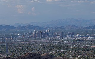
Phoenix is the capital and most populous city of the U.S. state of Arizona, with 1,608,139 residents as of 2020. It is the fifth-most populous city in the United States, the most populous state capital in the country, and the only U.S. state capital with a population of more than one million residents.

<span class="mw-page-title-main">Maricopa County, Arizona</span> County in Arizona, United States

Maricopa County is in the south-central part of the U.S. state of Arizona. As of the 2020 census the population was 4,420,568, or about 62% of the state's total, making it the fourth-most populous county in the United States, the most populous county in Arizona, and making Arizona one of the nation's most centralized states. The county seat is Phoenix, the state capital and fifth-most populous city in the United States.

<span class="mw-page-title-main">Phoenix metropolitan area</span> Metropolitan area in Arizona, United States

The Phoenix Metropolitan Area – also the Valley of the Sun, the Salt River Valley, or Metro Phoenix – is the largest metropolitan statistical area in the Southwestern United States, centered on the city of Phoenix, that includes much of the central part of Arizona. The United States Office of Management and Budget designates the area as the Phoenix-Mesa-Chandler Metropolitan Statistical Area (MSA), defining it as Maricopa and Pinal counties. It anchors the Arizona Sun Corridor megaregion along with the second most populous metropolitan area in the state, the Tucson metropolitan area. The gross domestic product of the Phoenix Metropolitan Area was $255 billion in 2018, 16th largest amongst metro areas in the United States.

<span class="mw-page-title-main">Arizona State Route 51</span> Freeway in the Phoenix metropolitan area in Arizona, United States

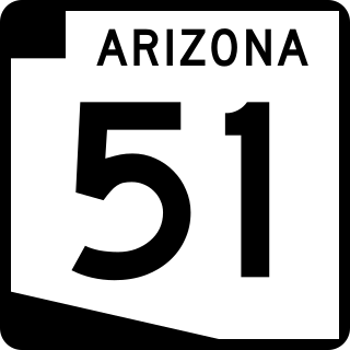
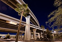
Arizona State Route 51 (SR 51), also known as the Piestewa Freeway, is a numbered state highway in Phoenix, Arizona. It connects Interstate 10 just outside Downtown Phoenix with Loop 101 on the north side of Phoenix, making it one of the area's major freeways. It is a largely north–south route and is known for traversing the Piestewa Peak Recreation Area. The peak was named after Lori Piestewa, the first Native American woman to die in combat in the U.S. military. Prior to this time, the freeway was known as the Squaw Peak Parkway, a name considered offensive by Native Americans. Rapid growth and increased traffic demand on the east side of Metro Phoenix made the Piestewa Freeway necessary.

<span class="mw-page-title-main">Arizona State Route 101</span> Freeway in the Phoenix metropolitan area, Arizona, United States

Arizona State Route 101 or Loop 101 is a semi-beltway looping around the Phoenix Metropolitan Area in central Arizona. It connects several suburbs of Phoenix, including Tolleson, Glendale, Peoria, Scottsdale, Mesa, Tempe, and Chandler. Construction began in the late-1980s and was completed in 2002.

<span class="mw-page-title-main">Arizona State Route 202</span> Freeway in the Phoenix metropolitan area in Arizona, United States

Arizona State Route 202 (SR 202) or Loop 202 is a semi-beltway circling the eastern and southern areas of the Phoenix metropolitan area in central Arizona. It traverses the eastern end and the southern end of the city of Phoenix, in addition to the cities of Tempe, Mesa, Chandler, and Gilbert, and is a vital route in the metropolitan area freeway system. Loop 202 has three officially designated sections along its route; the Red Mountain Freeway, the SanTan Freeway, and the Congressman Ed Pastor Freeway, previously named the South Mountain Freeway. The Red Mountain Freeway runs from the Mini Stack Interchange with Interstate 10 (I-10) and State Route 51 (SR 51) in Phoenix to the SuperRedTan Interchange with U.S. Route 60 (US 60) in Mesa. The SanTan Freeway runs from there to an interchange with Interstate 10 (I-10) in Chandler. The Congressman Ed Pastor Freeway runs from there to I-10 in western Phoenix.

<span class="mw-page-title-main">Valley Metro</span> Regional transportation system in Phoenix, AZ

The Valley Metro Regional Public Transportation Authority, more popularly known as Valley Metro, is the unified public brand of the regional transit system for the Phoenix metropolitan area. Within the system, it is divided between Valley Metro Bus, which runs all bus operations, and Valley Metro Rail, which is responsible for light rail operations in the Valley. In 2022, the combined bus and rail system had a ridership of 16,625,900, or about 53,300 per weekday as of the fourth quarter of 2022.

<span class="mw-page-title-main">Arizona State Route 143</span> Expressway/Freeway in the Phoenix metropolitan area, Arizona, United States

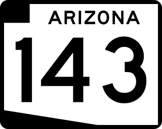
Arizona State Route 143, also known as SR 143 and the Hohokam Expressway, is a north–south and access-controlled freeway in Maricopa County, Arizona, that runs from a junction with Interstate 10 at 48th Street in Phoenix to McDowell Road. The only other major junction along the 3.93-mile (6.32 km) route is with Loop 202, which is located one half-mile south of McDowell Road and the northern terminus.

<span class="mw-page-title-main">Interstate 10 in Arizona</span> Interstate highway in Arizona

In the U.S. state of Arizona, Interstate 10 (I‑10), the major east–west Interstate Highway in the United States Sun Belt, runs east from California, enters Arizona near the town of Ehrenberg and continues through Phoenix and Tucson and exits at the border with New Mexico near San Simon. The highway also runs through the cities of Casa Grande, Eloy, and Marana. Segments of the highway are referred to as either the Papago Freeway, Inner Loop, or Maricopa Freeway within the Phoenix area and the Pearl Harbor Memorial Highway outside metro Phoenix.

<span class="mw-page-title-main">Arizona State Route 153</span> Former state highway in Arizona

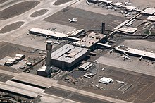
State Route 153, also known as SR 153 and the Sky Harbor Expressway, is a former state highway in Maricopa County, in the U.S. state of Arizona, that ran from the intersection of 44th Street and Washington Street in Phoenix south to University Drive. It was a controlled access arterial expressway, with a speed limit of 45 mph (72 km/h), lower than the standard freeway speed of 65 mph (105 km/h). Route 153 was a north–south route that skirted the eastern edge of Sky Harbor International Airport, and along with SR 143, SR 153 served a portion of East Valley residents with access to the airport. Many motorists used SR 143 instead, because of its quick access to and from Interstate 10 and Loop 202. The freeway did, however, provide a direct link to office developments in the Southbank commercial project in east Phoenix with the city of Tempe.

<span class="mw-page-title-main">Arizona State Route 303</span> State highway in Arizona, United States

Arizona State Route 303 or Loop 303, also known as the Bob Stump Memorial Parkway, is a freeway that serves the west part of the Phoenix metropolitan area. The freeway, originally a two-lane rural highway, was maintained by Maricopa County until 2004 when the Arizona Department of Transportation again took control of upgrading the interim road to a freeway.

<span class="mw-page-title-main">Arizona State Route 24</span> Planned state highway in Arizona

State Route 24, also known as the Gateway Freeway or the Williams Gateway Freeway, is a freeway in the extreme southeastern region of the Phoenix Metropolitan Area. The roadway is planned as a controlled-access highway to move traffic from the southeastern suburbs of Phoenix to planned ones in northwestern Pinal County. It is the lowest-numbered state route in Arizona. The first mile from Loop 202 to Ellsworth Road opened on May 4, 2014. An extension to Ironwood Drive opened in 2022, with the completion of "Interim Phase II"; the first mile of this extension from Ellsworth Road to Williams Field Road opened on April 1, 2022, with the remainder following on August 11. Planning for future sections has been halted until studies for the Pinal North-South Freeway are completed to confirm how the two freeways will intersect.

<span class="mw-page-title-main">U.S. Route 60 in Arizona</span> Section of U.S. Highway in Arizona, United States

U.S. Route 60 (US 60) is an east–west United States Highway within Arizona. The highway runs for 369 miles (594 km) from a junction with Interstate 10 near Quartzsite to the New Mexico State Line near Springerville. As it crosses the state, US 60 overlaps at various points: I-17, I-10, SR 77, SR 260, US 191, and US 180. Between Wickenburg and Phoenix, the route is known as Grand Avenue. From Tempe to Apache Junction, it is known as the Superstition Freeway.

The transportation system of Arizona comprises car, rail, air, bus, and bicycle transport.

The metropolitan area of Phoenix in the U.S. state of Arizona contains one of the nation's largest and fastest-growing freeway systems, with over 1,405 lane miles (2,261 km) as of 2005.

Below is a list and summary of the former state highways.

Many arterial roads in the Phoenix metropolitan area have the same name in multiple cities or towns. Some roads change names or route numbers across town borders, resulting in occasional confusion. For example, the road known as Apache Boulevard in Tempe continues east as Main Street in neighboring Mesa and then as Apache Trail in Apache Junction. Although Broadway Road maintains the same name through Goodyear, Avondale, Phoenix, Tempe, Mesa, and Apache Junction, each town uses a different reference point for address numbers.

<span class="mw-page-title-main">Bell Road (Phoenix Metro)</span> Arterial road in the northern Phoenix, Arizona metropolitan area

Bell Road is a major east-west arterial road in the northern Phoenix, Arizona metropolitan area. It is one of the few roadways to cross the Agua Fria River in the northwestern part of the metro area, providing a vital link between the growing suburb of Surprise with Phoenix. As a result, the portion of Bell Road passing through Surprise and Sun City is the busiest arterial road in the state of Arizona.

<span class="mw-page-title-main">Arizona Sun Corridor</span> Megaregion in Arizona, United States

The Arizona Sun Corridor, shortened Sun Corridor, is a megaregion, or megapolitan area, in the southern area of the U.S. state of Arizona. The Sun Corridor is comparable to Indiana in both size and population. It is one of the fastest growing conurbations in the country and is speculated to double its population by 2040. The largest metropolitan areas are the Phoenix metropolitan area – Valley of the Sun, and the Tucson metropolitan area – The Old Pueblo. The regions' populace is nestled in the valley of a desert environment. Similar to Southern California, the urban area extends into Mexico, reaching the communities of Nogales and Agua Prieta.

There is a current proposal to bring commuter rail service to the Phoenix metropolitan area.

References

  1. Hartgen, David T.; Fields, M. Gregory; San José, Elizabeth (July 2013). 20th Annual Report on the Performance of State Highway Systems. Reason Foundation.
  2. Eisele, Bill; Schrank, David; Lomax, Tim (November 2011). TTI's 2011 Congested Corridors Report. Texas A&M-Texas Transportation Institute.
  3. "Maricopa County Sales Tax Referendum Case Study" (PDF). Build America Transportation Investment Center. September 2009. Archived from the original (PDF) on October 9, 2015. Retrieved March 22, 2016.
  4. "Auxiliary Routes of the Dwight D. Eisenhower National System Of Interstate and Defense Highways as of October 31, 2002". Federal Highway Administration . Retrieved February 26, 2014.
  5. Artibise, Yuri; Gammage, Grady Jr.; Welch, Nancy (September 7, 2008). "Transformation into Big City has Benefits, Burdens". Arizona Republic . Retrieved October 12, 2008.
  6. "Phoenix Metro Area Projects". ADOT. Retrieved February 13, 2014.
  7. 1 2 3 4 "Phoenix Streets and Freeways". discoverphoenix.com. Archived from the original on January 15, 2014. Retrieved February 13, 2014.
  8. "History of Phoenix". City of Phoenix. Archived from the original on April 15, 2014. Retrieved April 15, 2014.
  9. "Airport Facts". skyharbor.com. Retrieved March 2, 2014.
  10. "Where We Fly". skyharbor.com. Retrieved March 2, 2014.
  11. "International Destinations". Archived from the original on February 27, 2017. Retrieved December 23, 2016.
  12. "Airlines". Sky Harbor Airport. Archived from the original on August 1, 2017. Retrieved December 23, 2016.
  13. Totten, Steven (December 7, 2016). "Phoenix-Mesa Gateway Airport continues to break passenger records". Phoenix Business Journal. Archived from the original on December 24, 2016. Retrieved December 23, 2016.
  14. "Phoenix-Mesa Gateway Airport celebrates eight million Allegiant passengers since 2007". Queen Creek Independent. December 16, 2016. Archived from the original on December 23, 2016. Retrieved December 23, 2016.
  15. "Arizona Transit Association". Azta.org. Archived from the original on October 2, 2013. Retrieved September 28, 2013.
  16. "Amtrak's Texas Eagle | Maricopa, AZ". Texaseagle.com. Archived from the original on September 8, 2013. Retrieved September 28, 2013.
  17. "Phoenix, AZ". TrainWeb.org. Retrieved February 13, 2014.
  18. "Phoenix–Tucson". Amtrak Connects US.
  19. "Current Valley Metro Projects". Valley Metro. Archived from the original on March 25, 2014. Retrieved February 26, 2014.
  20. "Amtrak's Southwest Chief". TrainWeb.org. Retrieved February 13, 2014.
  21. "Phoenix Greyhound Station". Greyhound. Archived from the original on February 21, 2016. Retrieved March 20, 2016.
  22. "Bicycle and Pedestrian Committee". Maricopa Association of Governments. Archived from the original on February 26, 2014. Retrieved February 3, 2017.