
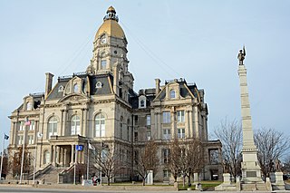
Wabash County is a county located in the northern central part of the U.S. state of Indiana. As of 2020, the population was 30,976. The county seat is Wabash.
Vigo County is a county on the western border of the U.S. state of Indiana. According to the 2020 United States Census, it had a population of 106,153. Its county seat is Terre Haute.

Carroll County is a county located in the U.S. state of Indiana. As of the 2020 United States Census, the population was 20,306. The county seat is Delphi.

The Miami are a Native American nation originally speaking one of the Algonquian languages. Among the peoples known as the Great Lakes tribes, they occupied territory that is now identified as north-central Indiana, southwest Michigan, and western Ohio. The Miami were historically made up of several prominent subgroups, including the Piankeshaw, Wea, Pepikokia, Kilatika, Mengakonkia, and Atchakangouen. In modern times, Miami is used more specifically to refer to the Atchakangouen. By 1846, most of the Miami had been forcefully displaced to Indian Territory. The Miami Tribe of Oklahoma are the federally recognized tribe of Miami Indians in the United States. The Miami Nation of Indiana, a nonprofit organization of descendants of Miamis who were exempted from removal, have unsuccessfully sought separate recognition.

Crawfordsville is a city in Montgomery County in west central Indiana, United States, 49 miles (79 km) west by northwest of Indianapolis. As of the 2020 census, the city had a population of 16,306. The city is the county seat of Montgomery County, the only chartered city and the largest populated place in the county. It is the principal city of the Crawfordsville, IN Micropolitan Statistical Area, which encompasses all of Montgomery County. The city is also part of the Indianapolis–Carmel–Muncie, IN Combined Statistical Area.

Wabash is a city in Noble Township, Wabash County, in the U.S. state of Indiana. The population was 10,666 at the 2010 census. The city is situated along the Wabash River in the county seat of Wabash County.

The Wabash River is a 503-mile-long (810 km) river that drains most of the state of Indiana in the United States. It flows from the headwaters in Ohio, near the Indiana border, then southwest across northern Indiana turning south near the Illinois border, where the southern portion forms the Indiana-Illinois border before flowing into the Ohio River.

The Wabash and Erie Canal was a shipping canal that linked the Great Lakes to the Ohio River via an artificial waterway. The canal provided traders with access from the Great Lakes all the way to the Gulf of Mexico. Over 460 miles long, it was the longest canal ever built in North America.

Fort Ouiatenon, built in 1717, was the first fortified European settlement in what is now Indiana, United States. It was a palisade stockade with log blockhouse used as a French trading post on the Wabash River located approximately three miles southwest of modern-day West Lafayette. The name 'Ouiatenon' is a French rendering of the name in the Wea language, waayaahtanonki, meaning 'place of the whirlpool'. It was one of three French forts built during the 18th century in what was then New France, later the Northwest Territory and today the state of Indiana, the other two being Fort Miami and Fort Vincennes. A substantial French settlement grew up around the fort in the mid-18th century. It was ceded to the British and abandoned after the French and Indian war. Later, it passed into Indian hands and was destroyed in 1791 by American militia during the Northwest Indian War. It was never a U.S. fort. The original site was rediscovered in the 1960s; the archaeological site was listed on the National Register of Historic Places in 1970, and was designated a National Historic Landmark in 2021.

The Wea were a Miami-Illinois-speaking Native American tribe originally located in western Indiana. Historically, they were described as either being closely related to the Miami Tribe or a sub-tribe of Miami.
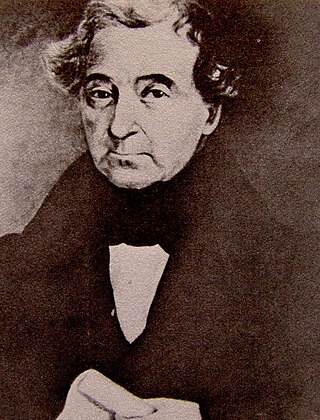
Jean Baptiste de Richardville, also known as Pinšiwa or Peshewa in the Miami-Illinois language or John Richardville in English, was the last akima 'civil chief' of the Miami people. He began his career in the 1790s as a fur trader who controlled an important portage connecting the Maumee River to the Little River in what became the present-day state of Indiana. Richardville emerged a principal chief in 1816 and remained a leader of the Miamis until his death in 1841. He was a signatory to the Treaty of Greenville (1795), as well as several later treaties between the U.S. government and the Miami people, most notably the Treaty of Fort Wayne (1803), the Treaty of Fort Wayne (1809), the Treaty of Saint Mary's (1818), the Treaty of Mississinewas (1826), the treaty signed at the Forks of the Wabash (1838), and the Treaty of the Wabash (1840).

The Treaty of St. Mary's may refer to one of six treaties concluded in fall of 1818 between the United States and Natives of central Indiana regarding purchase of Native land. The treaties were
Bonpas Creek is a tributary of the Wabash River in Illinois. It rises to the east of Olney in Richland County, Illinois. Flowing south, it forms the boundary between Edwards and Wabash counties. The creek is 58.4 miles (94.0 km) long. It joins the Wabash near Grayville, Illinois. In the last 2 miles (3 km) of its watercourse, it occupies part of a former Wabash oxbow bend. As such, the creek now also forms part of the state boundary between White County, Illinois, and Gibson County, Indiana, as flows past Grayville in the former channel.

Milan Township is one of twenty townships in Allen County, Indiana, United States. Milan Township is located in east central Allen County, with the Maumee River meandering across the township. As of the 2010 census, its population was 3,749. The township is highly rural, with only 1,137 houses in the 2010 census. Many of the residents of Milan Township are Swiss Amish who mostly speak a Low Alemannic Alsatian dialect. Milan township is generally demarcated by Schwartz Road to the west, Notestine Road to the north, Sampson Road to the east, and Gar Creek Road to the south.

Granville is a former town in Wayne Township, Tippecanoe County, in the U.S. state of Indiana.
Ouiatenon was a dwelling place of members of the Wea tribe of Native Americans. The name Ouiatenon, also variously given as Ouiatanon, Oujatanon, Ouiatano or other similar forms, is a French rendering of a term from the Wea dialect of the Miami-Illinois language which means "place of the people of the whirlpool", an ethnonym for the Wea. Ouiatenon can be said to refer generally to any settlement of Wea or to their tribal lands as a whole, though the name is most frequently used to refer to a group of extinct settlements situated together along the Wabash River in what is now western Tippecanoe County, Indiana.

Liberty Mills is an unincorporated community on the Eel River in Chester Township, Wabash County, in the U.S. state of Indiana. Proprietor John Comstock (1802–1879) platted the town June 24, 1837. The name Liberty Mills comes from the number of mills the town once operated, including a saw mill, a carding mill, and a distillery, with one of the mills coming from the ‘Liberty’ brand. Its ZIP code is 46946.
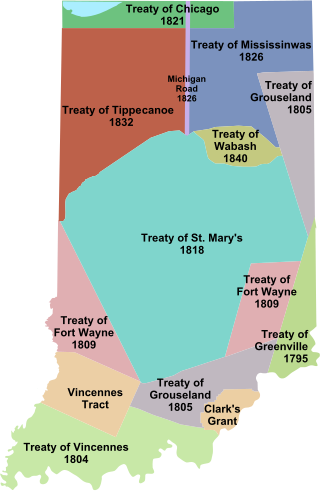
Indian removals in Indiana followed a series of the land cession treaties made between 1795 and 1846 that led to the removal of most of the native tribes from Indiana. Some of the removals occurred prior to 1830, but most took place between 1830 and 1846. The Lenape (Delaware), Piankashaw, Kickapoo, Wea, and Shawnee were removed in the 1820s and 1830s, but the Potawatomi and Miami removals in the 1830s and 1840s were more gradual and incomplete, and not all of Indiana's Native Americans voluntarily left the state. The most well-known resistance effort in Indiana was the forced removal of Chief Menominee and his Yellow River band of Potawatomi in what became known as the Potawatomi Trail of Death in 1838, in which 859 Potawatomi were removed to Kansas and at least forty died on the journey west. The Miami were the last to be removed from Indiana, but tribal leaders delayed the process until 1846. Many of the Miami were permitted to remain on land allotments guaranteed to them under the Treaty of St. Mary's (1818) and subsequent treaties.

The following outline is provided as an overview of and topical guide to the U.S. state of Indiana:


