
The Miami are a Native American nation originally speaking one of the Algonquian languages. Among the peoples known as the Great Lakes tribes, they occupied territory that is now identified as North-central Indiana, southwest Michigan, and western Ohio. The Miami were historically made up of several prominent subgroups, including the Piankeshaw, Wea, Pepikokia, Kilatika, Mengakonkia, and Atchakangouen. In modern times, Miami is used more specifically to refer to the Atchakangouen. By 1846, most of the Miami had been forcefully displaced to Indian Territory. The Miami Tribe of Oklahoma are the federally recognized tribe of Miami Indians in the United States. The Miami Nation of Indiana, a nonprofit organization of descendants of Miamis who were exempted from removal, have unsuccessfully sought separate recognition.

The Northwest Territory, also known as the Old Northwest and formally known as the Territory Northwest of the River Ohio, was formed from unorganized western territory of the United States after the American Revolutionary War. Established in 1787 by the Congress of the Confederation through the Northwest Ordinance, it was the nation's first post-colonial organized incorporated territory.

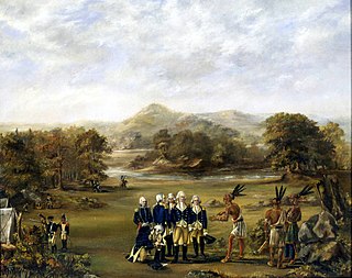
The Treaty of Greenville, formally titled Treaty with the Wyandots, etc., was a 1795 treaty between the United States and indigenous nations of the Northwest Territory, including the Wyandot and Delaware peoples, that redefined the boundary between indigenous peoples' lands and territory for European American community settlement.

The Maumee River is a river running in the United States Midwest from northeastern Indiana into northwestern Ohio and Lake Erie. It is formed at the confluence of the St. Joseph and St. Marys rivers, where Fort Wayne, Indiana has developed, and meanders northeastwardly for 137 miles (220 km) through an agricultural region of glacial moraines before flowing into the Maumee Bay of Lake Erie. The city of Toledo is located at the mouth of the Maumee. The Maumee was designated an Ohio State Scenic River on July 18, 1974. The Maumee watershed is Ohio's breadbasket; it is two-thirds farmland, mostly corn and soybeans. It is the largest watershed of any of the rivers feeding the Great Lakes, and supplies five percent of Lake Erie's water.

The Connecticut Western Reserve was a portion of land claimed by the Colony of Connecticut and later by the state of Connecticut in what is now mostly the northeastern region of Ohio. The Reserve had been granted to the Colony under the terms of its charter by King Charles II.

The Ohio Lands were the several grants, tracts, districts and cessions which make up what is now the U.S. state of Ohio. The Ohio Country was one of the first settled parts of the Midwest, and indeed one of the first settled parts of the United States beyond the original Thirteen Colonies. The land that became first the anchor of the Northwest Territory and later Ohio was cobbled together from a variety of sources and owners.
The Northwest Indian War (1785–1795), also known by other names, was an armed conflict for control of the Northwest Territory fought between the United States and a united group of Native American nations known today as the Northwestern Confederacy. The United States Army considers it the first of the American Indian Wars.

Fort Defiance was built by General "Mad" Anthony Wayne in the second week of August 1794 at the confluence of the Auglaize and Maumee rivers. It was the one of a line of defenses constructed by American forces in the campaign leading to the Northwest Indian War's Battle of Fallen Timbers on August 20, 1794.

Fort Miami (Miamis) was a British fort built in spring 1794 on the Maumee River in what was at the time territory claimed by the United States, and designated by the federal government as the Northwest Territory. The fort was located at the eastern edge of present-day Maumee, Ohio, southwest of Toledo. The British built the fort to forestall a putative assault on Fort Detroit by Gen. "Mad" Anthony Wayne's army, then advancing northward in southwestern Ohio.
The Treaty of Fort McIntosh was a treaty between the United States government and representatives of the Wyandotte, Delaware, Chippewa and Ottawa nations of Native Americans. The treaty was signed at Fort McIntosh on January 21, 1785. It contained 10 articles and an addendum.

The Treaty of Fort Harmar (1789) was an agreement between the United States government and numerous Native American tribes with claims to the Northwest Territory.

The Treaty of Fort Meigs, also called the Treaty of the Maumee Rapids, formally titled, "Treaty with the Wyandots, etc., 1817", was the most significant Indian treaty by the United States in Ohio since the Treaty of Greenville in 1795. It resulted in cession by bands of several tribes of nearly all their remaining Indian lands in northwestern Ohio. It was the largest wholesale purchase by the United States of Indian land in the Ohio area. It was also the penultimate one; a small area below the St. Mary's River and north of the Greenville Treaty Line was ceded in the Treaty of St. Mary's in 1818.

The Congress Lands North of the Old Seven Ranges was a land tract in northeast Ohio that was established by the Congress early in the 19th century. It is located south of the Connecticut Western Reserve and Firelands, east of the Congress Lands South and East of the First Principal Meridian, north of the United States Military District and Seven Ranges, and west of Pennsylvania.

The Treaty of Brownstown was between the United States and the Council of Three Fires, Wyandott, and Shawanoese Indian Nations. It was concluded November 25, 1808, at Brownstown in Michigan Territory, and provided cession of a strip of Indian land for a road to connect two disconnected areas of land previously ceded by Indians in Michigan and Ohio.
Maumee Road Lands were a group of land tracts granted by the United States Congress to the state of Ohio in 1823 along the path of a proposed road in the northwest corner of the state.
Turnpike Lands were a group of land tracts granted by the United States Congress to the state of Ohio in 1827 along the path of a proposed road in the northwest corner of the state.
The Twelve Mile Square Reservation, also called the Twelve Mile Square Reserve, was a tract of land in Ohio ceded by Indians to the United States of America in the Treaty of Greenville in 1795. This particular area of land immediately surrounding Fort Miami was considered to be of strategic importance by the United States government representatives. It was subsequently surveyed in a manner different from surrounding land, and lots sold, or granted, to settlers.

North and East of the First Principal Meridian is a survey and land description in the northwest part of the U.S. state of Ohio.
Indian removals in Ohio started in the late eighteenth century after the American victory in the Revolutionary War and the consequent opening of the Northwestern United States to European-American settlement. Native American tribes residing in the region banded together to resist settlement, resulting in the disastrous Northwest Indian War where the Native tribes ceded large swathes of territory to the American government. After the American victory in the war, several Indian reservations were established to forcibly relocate landless tribes to. The process of obtaining full American sovereignty over Indian territories in Ohio was complete around 1818, but continued in Indiana until 1840.

