
Robert Francis Kilvert, known as Francis or Frank, was an English clergyman whose diaries reflected rural life in the 1870s, and were published over fifty years after his death.

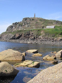
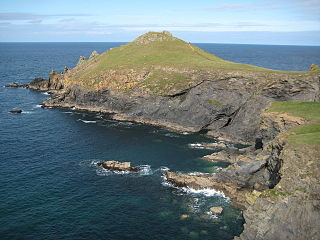
Treen is a small village in the parish of St Levan, in the far west of Cornwall, England, United Kingdom. It is about 3 miles (4.8 km) inland from Land's End on a short unclassified spur road from the B3315. Treen overlooks the Penberth Valley and sits about 1 kilometre (0.62 mi) inland from Treryn Dinas, an Iron Age promontory fort, or cliff castle, with five lines of fortification. On the headland is the Logan Rock and to the west is Pedn Vounder tidal beach, which is popular with naturists. Treen Cliff is to either side of Treryn Dinas. The village has a popular pub, The Logan Rock Inn, a village shop, cafe and campsite with views to both Logan Rock and nearby Porthcurno.
Priest Cove or Priest's Cove is a small cove one mile (1.6 km) west of St Just, Cornwall, UK. The name is from the Cornish Porth Ust, the port or cove of St Just, which was shortened to Por’ Ust. The apostrophised name "Priest’s" is a spelling mistake and the site has no connection with the clergy.

Coverack is a coastal village and fishing port in Cornwall, UK. It lies in the parish of St Keverne, on the east side of the Lizard peninsula about nine miles (14 km) south of Falmouth.
Zennor is a village and civil parish in Cornwall, England, United Kingdom. The parish includes the villages of Zennor, Boswednack and Porthmeor and the hamlet of Treen. Zennor lies on the north coast, about 6 miles (10 km) north of Penzance, along the B3306 road which connects St Ives to the A30 road. Alphabetically, the parish is the last in Britain. Its name comes from the Cornish name for the local saint, Saint Senara.

St Levan is a civil parish in Cornwall, England, United Kingdom. The parish is rural with a number of hamlets of varying size with Porthcurno probably being the best known. Hewn out of the cliff at Minack Point and overlooking the sea to the Logan Rock is the open-air Minack Theatre, the inspiration of Rowena Cade in the early 1930s.

Gunwalloe is a coastal civil parish in Cornwall, England, United Kingdom. It is situated on the Lizard Peninsula three miles (4.8 km) south of Helston and partly contains The Loe, the largest natural freshwater lake in Cornwall. The parish population including Berepper at the 2011 census was 219. The hamlets in the parish are Chyanvounder, Berepper and Chyvarloe. To the east are the Halzephron cliffs and further east the parish church.

The Logan Rock near the village of Treen in Cornwall, England, UK, is an example of a logan or rocking stone. Although it weighs some 80 tons, it was dislodged in 1824 by a group of British seamen, intent on showing what the Navy could do. However following complaints from local residents for whom the rock had become a tourist attraction and source of income, the seamen were forced to restore it. Today the Logan Rock still rocks, but with much less ease than it did in the past. The South West Coast Path, which follows the coast of south-west England from Somerset to Dorset passes by on the cliffs to the north.
The Carracks and Little Carracks are a group of small rocky inshore islands off the Atlantic north coast of west Cornwall, England, United Kingdom. The name comes from "carrek", the Cornish language word for 'rock'. The Little Carracks were still known as Carrack an Heythen c. 1920. The islands are in Zennor civil parish.
The Rumps is a twin-headland promontory at the north-east corner of Pentire Head in north Cornwall, United Kingdom.
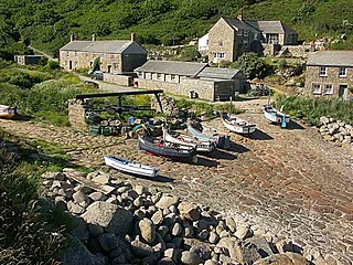
Penberth is a valley, coastal village and cove on the Penwith peninsula in Cornwall, England. It is approximately 7 miles (11 km) southwest of Penzance. Most of the village is within the parish of St Buryan and the boundary with St Levan follows the Penberth river.

Gurnard's Head is a prominent headland on the north coast of the Penwith peninsula in Cornwall, England, UK. The name is supposed to reflect the fact that the rocky peninsula resembles the head of the gurnard fish.
Pendour Cove is a beach in west Cornwall, England, UK. It is about 1 mile northwest of the village of Zennor, and immediately to the west of Zennor Head.

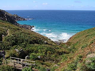
Pedn Vounder is a tidal beach on the south coast of the Penwith peninsula, Cornwall, England, UK. It is immediately to the west of the Logan Rock headland, below Treen Cliff. The name is from the Cornish 'pedn' and 'vounder' (lane).

Treen is a hamlet in the parish of Zennor, on the north coast of the Penwith peninsula in Cornwall, England, United Kingdom. It lies along the B3306 road which connects St Ives to the A30 road. At Gurnard's Head nearby on the coast is one of the many cliff castles on the Cornish coast which was formerly a Coastguard Lookout. To the east of Gurnard's Head is Treen Cove. The area is owned by the National Trust.
Tullimaar House is a mansion just east of Perranarworthal in west Cornwall, England, United Kingdom; it is not visible from the main A39 Falmouth to Truro road, and stands in private grounds. However, the white gate forming the entrance to the property can be seen from the road.

Gerrans Bay to Camels Cove is a coastal Site of Special Scientific Interest (SSSI) in south Cornwall, England, UK, noted for both its biological and geological interest.

Zennor Head is a 750-metre (2,460 ft) long promontory on the Cornish coast of England, between Pendour Cove and Porthzennor Cove. Facing the Atlantic Ocean, it lies 1 kilometre north-west of the village of Zennor and 1.6 kilometres east of the next promontory, Gurnard's Head. The granite (Killas) cliffs rise over 200 feet (60 m) from the sea and the highest point of the headland is 314 feet (96 m) above sea level, with an Ordnance Survey triangulation station. Zennor Head is on the South West Coast Path, which follows the cliff edge closely, skirting the entire perimeter of the headland. The promontory is part of the Penwith Heritage Coast, and is the largest coastal feature in the United Kingdom that begins with the letter "Z". It gets its name from a local saint, Senara. Zennor Head was mined for copper and tin in the Victorian Era. There is no longer any residential or commercial occupancy on the headland, but it is occupied by a variety of coastal animals and plants, such as kestrels and gorse.

Cornish promontory forts, commonly known in Cornwall as cliff castles, are coastal equivalents of the hill forts and Cornish "rounds" found on Cornish hilltops and slopes. Similar coastal forts are found on the north–west European seaboard, in Normandy, Brittany and around the coastlines of the British Isles, especially in Wales, Scotland and Ireland. Many are known in southwest England, particularly in Cornwall and its neighbouring county, Devon. Two have been identified immediately west of Cornwall, in the Isles of Scilly.

St Buryan was an electoral division of Cornwall in the United Kingdom which returned one member to sit on Cornwall Council between 2009 and 2021. It was abolished at the 2021 local elections, being succeeded by Land's End, Ludgvan, Madron, Gulval and Heamoor, and Mousehole, Newlyn and St Buryan.
