
Lake Tana is the largest lake in Ethiopia and the source of the Blue Nile. Located in Amhara Region in the north-western Ethiopian Highlands, the lake is approximately 84 kilometres long and 66 kilometres wide, with a maximum depth of 15 metres, and an elevation of 1,788 metres. Lake Tana is fed by the Gilgel Abay, Reb and Gumara rivers. Its surface area ranges from 3,000 to 3,500 square kilometres, depending on season and rainfall. The lake level has been regulated since the construction of the control weir where the lake discharges into the Blue Nile. This controls the flow to the Blue Nile Falls and hydro-power station.

The Drakensberg is the eastern portion of the Great Escarpment, which encloses the central Southern African plateau. The Great Escarpment reaches its greatest elevation – 2,000 to 3,482 metres within the border region of South Africa and Lesotho.

Mpumalanga is a province of South Africa. The name means "east", or literally "the place where the sun rises" in the Swazi, Xhosa, Ndebele and Zulu languages. Mpumalanga lies in eastern South Africa, bordering Eswatini and Mozambique. It constitutes 6.5% of South Africa's land area. It shares borders with the South African provinces of Limpopo to the north, Gauteng to the west, the Free State to the southwest, and KwaZulu-Natal to the south. The capital is Mbombela.

The Celebes Sea of the western Pacific Ocean is bordered on the north by the Sulu Archipelago and Sulu Sea and Mindanao Island of the Philippines, on the east by the Sangihe Islands chain, on the south by Sulawesi's Minahasa Peninsula, and on the west by northern Kalimantan in Indonesia. It extends 420 miles (675 km) north-south by 520 mi (840 km) east-west and has a total surface area of 110,000 square miles (280,000 km2), to a maximum depth of 20,300 feet (6,200 m). South of the Cape Mangkalihat, the sea opens southwest through the Makassar Strait into the Java Sea.

The Olifants River,Lepelle, iBhalule or Obalule is a river in South Africa and Mozambique, a tributary of the Limpopo River. It falls into the Drainage Area B of the Drainage basins of South Africa. The historical area of the Pedi people, Sekhukhuneland, is located between the Olifants River and one of its largest tributaries, the Steelpoort River.
The Blyde River Canyon is a 26km long Canyon located in Mpumalanga, South Africa. It is the one of the larger canyons on Earth but much smaller than those of Asia, the Grand Canyon and the Fish River Canyon. Unlike the Grand and Fish River Canyon, the Blyde River Canyon is a "green canyon" which is dominated by subtropical vegetation.
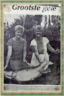
The largemouth yellowfish or Vaal-Orange largemouth yellowfish is a ray-finned fish species in the family Cyprinidae. This large freshwater barb is found in southern Africa.
The Treur River barb or simply Treur barb is a species of cyprinid fish. It is endemic to northern Mpumalanga, South Africa.

The Berlin Falls is a waterfall in Mpumalanga, South Africa. They are located close to God's Window and the highest waterfall in South Africa's Mpumalanga province, Lisbon Falls. They are less than a tenth of the height of South Africa's tallest waterfall, the Tugela Falls, and are better known for their beauty.

Blyde River Canyon Nature Reserve is situated in the Drakensberg escarpment region of eastern Mpumalanga, South Africa. The reserve protects the Blyde River Canyon, including sections of the Ohrigstad and Blyde Rivers and the geological formations around Bourke's Luck Potholes, where the Treur River tumbles into the Blyde below. Southwards of the canyon, the reserve follows the escarpment, to include the Devil's and God's Window, the latter a popular viewpoint to the lowveld at the reserve's southern extremity.

Blyderivierpoort Dam is a gravity-arch dam on the Blyde River, in the lower Blyde River Canyon, near Hoedspruit in Mpumalanga, South Africa. It also floods the lower reaches of the Blyde's Ohrigstad River tributary. The dam was completed in 1974. The 71 m high dam wall and 22 m deep is situated 3 km from Swadini resort by road.

The Motlatse River, Blyde River, or Umdhlazi River is a river in the Mpumalanga and Limpopo provinces of South Africa. It has a northwards course in steep-sided valleys and ravines of the Mpumalanga Drakensberg, before it enters the lowveld region of the Limpopo province. It has its ultimate origins at around 2,000 m altitude in the Hartebeesvlakte conservation area, to the north of Long Tom Pass. It runs through the Blyde River Canyon.
Ohrigstad River is located in Mpumalanga, South Africa. The Ohrigstad River joins the Blyde River at the Blyderivierpoort Dam in the Blyde River Canyon Nature Reserve. Like the Blyde, it has its ultimate origin at around 2,000 m altitude to the south, on the verge of the Hartebeesvlakte conservation area, but follows a more westerly course.
The Kruger to Canyons Biosphere Region is a biosphere reserve situated in the north eastern region of South Africa, straddling Limpopo and Mpumalanga Provinces. In 2001, under the supervision of the then Department of Environmental Affairs (DEA), the Kruger to Canyons Biosphere Region was officially ratified by UNESCO as part of the Man and the Biosphere (MaB) Programme. UNESCO's Man and the Biosphere Programme provides a framework for exploring local solutions to challenges by mainstreaming biodiversity conservation and sustainable development, integrating economic, social and environmental aspects and recognizing their vital linkages within specific learning landscapes adjacent to Protected Areas.
The Mooi River is a river in North West Province, South Africa. It is a tributary of the Vaal River and belongs to the Upper Vaal Water Management Area.
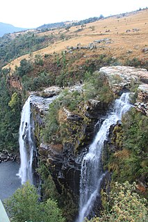
The Lisbon Falls are falls in the Lisbon Creek, a right bank tributary of the Blyde River. They are situated a short distance north of Graskop beside the R532 road, and are the highest waterfalls in Mpumalanga, South Africa. The waterfalls are 94 metres (308 ft) high and were named for the capital city of Portugal.

Mariepskop, at 1,947 m above sea level, is one of the highest peaks in the northern Drakensberg, and the highest point of the Blyde River Canyon, South Africa. It is situated at the junction of three conservation areas, namely the Mariepskop Forest Reserve, Mariepskop State Forest, and the Blyde River Canyon Nature Reserve. The mountain is bordered by sheer cliff faces on several sides, and is composed of Proterozoic sedimentary rocks of the Transvaal Supergroup. It is named for the 19th century Pulana chief, Maripe Mashile, whose tribe used the mountain as a stronghold. Some infrastructure and roads were built in the 1950s to service a military radar station. Mariepskop is flanked by Tshwateng (1,628 m) at the opposite side of the Blyde River, and by Hebronberg (1,767 m) in the south.
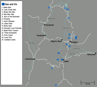
The Panorama Route is a scenic road in South Africa connecting several cultural and natural points of interest. The route, steeped in the history of South Africa, is in Mpumalanga province, centred around the Blyde River Canyon, the world's third largest canyon. It features numerous waterfalls, one of the largest afforested areas in South Africa, and several natural landmarks. The route starts at the foot of the Long Tom Pass just outside Lydenburg, following the natural descent from the Great Escarpment to the Lowveld, and ending at the border of the Mpumalanga and Limpopo provinces near the Echo Caves.
Afroedura rondavelica, also known as the Blyde River flat gecko or rondavel rock gecko, is a species of African geckos, first found in the Limpopo and Mpumalanga provinces of South Africa. Its specific and common name refers to the rondavel, a southern African hut-type structure.
Spring Creek is a stream in Maries and Phelps counties of Missouri. It is a tributary of Gasconade River.

