Treverbyn

Last updated

Houses at Ruddlemoor Roadside Houses at Ruddlemoor - geograph.org.uk - 974077.jpg
Houses at Ruddlemoor

Treverbyn is a civil parish and village in mid-Cornwall, England, United Kingdom, lying north of St Austell.

Contents

The parish includes the villages of Treverbyn, Carclaze, Stenalees, Penwithick, Bugle (the largest of these), Rescorla, Kerrow Moor, Carthew, Ruddlemoor, Bowling Green, Resugga Green, Scredda and parts of Trethurgy. The parish population at the 2011 census including Carluddon, Greensplatt, Knightor, Lavrean and Lower Menadue was 8,016. [1] There is a railway station at Bugle.

Geography

Hensbarrow Beacon near Stenalees is the highest point of the St Austell Downs.

Treverbyn village is on the eastern outskirts of Stenalees and has the parish church, St Peter's. [2] Another hamlet called Treverbyn lies to the east of Penwithick. [3]

History

A converted Methodist chapel at Carthew Converted Chapel at Carthew - geograph.org.uk - 974108.jpg
A converted Methodist chapel at Carthew

The Manor of Treverbyn was recorded in the Domesday Book (1086) when it was one of 28 manors held by Richard from Robert, Count of Mortain. There was one virgate of land and land for 3 ploughs. There were one and a half ploughs, 2 serfs, 2 villeins, 4 smallholders, 2 acres of woodland and 20 acres of pasture. The value of the manor was only 5 shillings, although it had formerly been worth 10 shillings. [4] The manor of Tewington was one of the seventeen Antiqua maneria of the Duchy of Cornwall.

The parish was formed from the northern part of St Austell parish in 1846. [5] [6]

The church of St Peter the Apostle was built in 1848–1850 to designs of G. E. Street. Its Historic England listing states that the building "expresses the simplicity of design characteristic of the early Ecclesiological movement". [7]

Arms of the Martyn family, Lord of the Manor: Argent two bars gules Blason-argent-2-fasces-gueules.svg
Arms of the Martyn family, Lord of the Manor: Argent two bars gules

Mining

The entrance to the Gunheath china clay pit Entrance to the Gunheath Pit - geograph.org.uk - 974179.jpg
The entrance to the Gunheath china clay pit

The area was once the site of tin and copper mines but during the 19th century extensive china clay works were established, including one of the largest at Carclaze.[ citation needed ]

The Wheal Martyn Museum is at Ruddlemoor. Part of the area forms the Wheal Martyn SSSI (Site of Special Scientific Interest), noted for its examples of granite. [8] Also within the parish is Carn Grey Rock and Quarry SSSI, again noted for its geology. [9]

Eco-town

In 2009, the clay company Imerys announced Baal Pit and West Carclaze would be the locations for up to 2,000 new eco-homes. The project was estimated to cost £9 million. [10] The Baal pit was used in the 1971 Doctor Who episode Colony in Space featuring Jon Pertwee. The quarry was used to depict the surface of planet Uxarieus. [11]

Cornish wrestling

Cornish wrestling tournaments were held in a field behind the Carthew Inn in Carthew in the 1800s and 1900s. [12] [13]

Related Research Articles

<span class="mw-page-title-main">St Neot, Cornwall</span> Human settlement in England

St Neot is a village and civil parish in Cornwall, England, United Kingdom. The parish population at the 2011 census was 947. It is between the towns of Bodmin and Liskeard.

<span class="mw-page-title-main">St Austell</span> Town in Cornwall, England

Saint Austell is a town in Cornwall, England, United Kingdom, 10 miles (16 km) south of Bodmin and 30 miles (48 km) west of the border with Devon.

<span class="mw-page-title-main">Tregony</span> Village and former civil parish in Cornwall, England

Tregony, sometimes in the past Tregoney, is a village and former civil parish, now in the parish of Tregony with Cuby, in Cornwall, England, United Kingdom. It lies on the River Fal. In the village there is a post office, The Kings Arms Pub, shop, a sports and social club and two churches. Tregony has bus links to the nearest city, Truro. Cornelly parish was united with Tregony in 1934. On 1 April 2021 the parish was abolished and merged with Cuby to form "Tregony with Cuby". Tregony was once a port, but clay mining upriver in St Austell has caused the river to become silted over. The population was 768 in 2011 with nearly 15% claiming Cornish identity.

<span class="mw-page-title-main">Boyton, Cornwall</span> Human settlement in England

Boyton is a civil parish and village in Cornwall, England, United Kingdom. It is situated close to the River Tamar and the border with Devon about six miles (10 km) north of Launceston. According to the 2001 census it had a population of 378.This increased to 457 at the 2011 census.

Delabole is a large village and civil parish in north Cornwall, England, United Kingdom, which lies approximately two miles (3 km) west of Camelford.

<span class="mw-page-title-main">Breage, Cornwall</span> Human settlement in England

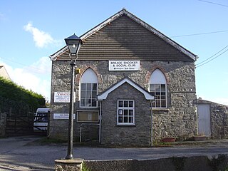
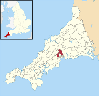
Breage is a civil parish and village in Cornwall, England, United Kingdom. The village is three miles (5 km) west of Helston.

<span class="mw-page-title-main">Mullion, Cornwall</span> Human settlement in England

Mullion is a civil parish and village on the Lizard Peninsula in south Cornwall, England, United Kingdom. The nearest town is Helston approximately 5 miles (8 km) to the north.

<span class="mw-page-title-main">St Stephen-in-Brannel</span> Human settlement in England

St Stephen-in-Brannel is a civil parish and village in mid Cornwall, England. The village is four miles (6.5 km) west of St Austell on the southern edge of Cornwall's china clay district. The parish also contains the villages of Foxhole, Nanpean, Treviscoe and Whitemoor, and the hamlets of Carpalla, Coombe, Currian Vale, High Street, Hornick, Lanjeth, Stepaside and Terras. The population of the civil parish at the 2011 census was 7,119. An electoral ward also exists, bearing the name St. Stephen. The population at the same census was 4,772 only.

<span class="mw-page-title-main">Clay Trails</span>

The Clay Trails are a series of bicycle trails located in mid Cornwall, England, United Kingdom. The trails pass through the St Austell moorland which for over two centuries has been extensively quarried for china clay, hence the name.

<span class="mw-page-title-main">Greensplat</span>

Greensplat is a location in south Cornwall, England, United Kingdom. It is immediately west of Carthew and is approximately two miles (3 km) north of St Austell. According to the Post Office the 2011 census population was included in the civil parish of Treverbyn.

<span class="mw-page-title-main">Penwithick</span> Village in Cornwall, England

Penwithick or Penwithick Stents is a village in Cornwall, England, United Kingdom. It is situated 2.5 miles (4.0 km) north of St Austell, in the civil parish of Treverbyn in the 'clay country' area of china clay quarrying. Whilst falling in a different civil parish Penwithick does have an electoral ward in its own name. The population of the ward at the census 2011 was 4,479

<span class="mw-page-title-main">Week St Mary</span> Civil parish and village in northeast Cornwall, England

Week St Mary is a village and civil parish in northeast Cornwall, England, United Kingdom. It is situated south of Bude close to the River Tamar and the border between Cornwall and Devon in the Hundred of Stratton. The parish population at the 2011 census is 657.

The St Austell and Clay Country Eco-town is a plan to build a new town on a cluster of sites owned by mining company Imerys near St Austell, in Cornwall, England. The plan was given outline government approval in July 2009. The plan would need to gain full planning permission before construction commenced.

<span class="mw-page-title-main">Lezant</span> Human settlement in England

Lezant is a civil parish and village in east Cornwall, England, United Kingdom. Lezant village is about five miles south of Launceston. The population of the parish in the 2001 census was 751, increasing slightly to 765 in the 2011 census.

<span class="mw-page-title-main">St Mellion</span> Village in Cornwall, England

St Mellion is a village and rural civil parish in east Cornwall, England, United Kingdom. The parish is about 3 miles (5 km) south of Callington and is in the St Germans Registration District. To the north, the parish is bordered by Callington and St Dominick parishes, to the east and south by Pillaton parish, and to the west by St Ive parish.

<span class="mw-page-title-main">Bugle, Cornwall</span> Human settlement in England

Bugle is a village in mid Cornwall, England, United Kingdom. It is in the parish of Treverbyn and is situated about five miles (8 km) north of St Austell on the A391 road. The 2011 Census for the ward of Bugle which includes Treverbyn and surrounding hamlets gave a population of 4,164.

<span class="mw-page-title-main">Wheal Martyn</span> Open-air museum in Cornwall, grid reference SX

The Wheal Martyn China Clay Museum is a museum of china clay mining, at Carthew, on the B3274 road about 2 miles (3.2 km) north of St Austell in Cornwall, England. A Victorian clay works has been preserved, and there is an exhibition building.

<span class="mw-page-title-main">Penwithick and Boscoppa (electoral division)</span> Electoral division of Cornwall in the UK

Penwithick and Boscoppa is an electoral division of Cornwall in the United Kingdom and returns one member to sit on Cornwall Council. The current Councillor is Matthew Luke, a member of Mebyon Kernow, a Cornish nationalist party.

<span class="mw-page-title-main">Bugle (electoral division)</span> Electoral division of Cornwall in the UK

Bugle was an electoral division of Cornwall in the United Kingdom which returned one member to sit on Cornwall Council between 2009 and 2021. It was abolished at the 2021 local elections, being divided between the new divisions of Roche and Bugle, Lostwithiel and Lanreath, and Penwithick and Boscoppa.

References

  1. "Parish population 2011" . Retrieved 14 March 2017.
  2. "Treverbyn: St Peter the Apostle". A Church Near You. The Archbishops' Council. Retrieved 14 June 2024.
  3. "Map of the Penwithick area". Streetmap.co.uk. Retrieved 14 June 2024.
  4. Thorn, C. et al., ed. (1979) Cornwall. Chichester: Phillimore; entry 5,3,15
  5. "Genuki: Treverbyn, Cornwall". www.genuki.org.uk. Retrieved 14 June 2024.
  6. Cornish Church Guide (1925) Truro: Blackford; p. 209
  7. Historic England. "Church of St Peter (1289533)". National Heritage List for England . Retrieved 14 June 2024.
  8. "Wheal Martyn" (PDF). Natural England. 1990. Retrieved 14 March 2017.
  9. "Carn Grey Rock and Quarry" (PDF). Natural England. 1991. Retrieved 30 October 2011.
  10. "Cornish eco-town given £9m start". BBC News. 8 February 2010. Retrieved 14 March 2017.
  11. Doctor Who - The Locations Guide
  12. West Briton and Cornwall Advertiser, 18 July 1871.
  13. Western Morning News, 28 June 1937.

Commons-logo.svg Media related to Treverbyn at Wikimedia Commons

50°22′41″N4°46′37″W / 50.378°N 4.777°W / 50.378; -4.777