Trevi (rione of Rome)

Last updated

Trevi
Rione of Rome
Trevi-Brunnen abends.jpg
Trevi Fountain: the most famous monument in the area
Rome - Muni 1 - Trevi.PNG
Position of the rione within the center of the city
CountryItaly
Region Lazio
Province Rome
Comune Rome
Time zone UTC+1 (CET)
  Summer (DST) UTC+2 (CEST)

Trevi is the 2nd rione of Rome, Italy, identified by the initials R. II, located in Municipio I. The origin of its name is not clear, but the most accepted theory is that it comes from the Latin trivium (meaning 'three streets'), because there were three streets all leading to the current Piazza dei Crociferi, a square next to the modern Trevi square. Its coat of arms is made of three swords on a red background.

Contents

History

This rione, during the Roman republic belonged to the third region, while during the Roman empire was split up into two regions: the VI, called Alta Semita and the VII, called via Lata.

During the ancient Roman period, in rione Trevi there were large groups of private houses with some monumental buildings. Since that time the area was actually split up into two parts: a lower one, level and next to the river Tiber, and a higher one on the hills. The first one was one of the center of the activities of the city, while the second one was a rich and peaceful residential area.

After the fall of the Roman empire, a lot of people moved away from the hills to settle next to the river, in the lower part. The urbanization followed the people: next to the river Tiber the rione was full of buildings while almost nothing was built again on the hills until the Renaissance.

Piazza dei Crociferi, with the Church of Santa Maria in Trivio Santa Maria in Trivio - esterno.jpg
Piazza dei Crociferi, with the Church of Santa Maria in Trivio

In 1600 urbanization, new streets, churches and fountains caused the rione Trevi to be quite crowded, and it did not change significantly until the end of the 19th century. The Quirinal Hill, partially isolated from the crowded part close to the river, was slowly becoming a center of power thanks to numerous buildings belonging to the Pope.

Under the domination of Napoleon, in 1811, the Quirinal Hill was selected to be the center of the imperial power in Rome. The plan was not completed because of the fall of Napoleon, but the idea remained and was partially achieved after Rome became capital of Italy, after the 1870. In fact nowadays several ministries are placed in the rione Trevi.

This changed completely the appearance of the higher part of the rione, that was not very crowded but full of small streets, churches and monumental buildings.

The most famous monument in the rione is Trevi Fountain.

Geography

Boundaries

Northward, Trevi borders with Colonna (R. III), whose boundary is marked by a brief stretch of Via del Corso and by Via delle Muratte, Via di Santa Maria in Via, Largo San Claudio, Via del Pozzetto, Via del Bufalo, Largo del Nazareno, Via del Nazareno, Via del Tritone and Piazza Barberini. It also borders with Ludovisi (R. XVI), through Via di San Basilio.

Eastward, the rione borders with Sallustiano (R. XVII), from which is separated by Via Leonida Bissolati, Via Giosuè Carducci, Via di Santa Susanna and Largo di Santa Susanna, and with Castro Pretorio (R. XVIII), from which is separated by Piazza San Bernardo and Via XX Settembre.

To the south, the rione borders with Monti (R. I), from which is separated by the Foro Traiano, Via IV Novembre, Largo Magnanapoli, Via XXIV Maggio and Via del Quirinale. Southward, it also shares a short boundary with Campitelli (R. X), which is marked by a portion of Piazza Venezia.

To the west, Trevi borders with Pigna (R. IX), and the boundary is outlined by Piazza Venezia and Via del Corso.

Local geography

Squares
Roads

Places of interest

Palaces and other buildings

Churches

Fountains

Education

Public libraries in Trevi include Biblioteca Romana Sarti, that was established in 1881 by the architect Antonio Sarti and Casa delle Traduzioni. [1]

Related Research Articles

<span class="mw-page-title-main">Properties of the Holy See</span> List of real estate regulated by Lateran Treaty

The properties of the Holy See are regulated by the 1929 Lateran Treaty signed with the Kingdom of Italy. Although part of Italian territory, some of them enjoy extraterritoriality similar to those of foreign embassies.

Monti (<i>rione</i> of Rome) Rione of Rome in Lazio, Italy

Monti is the 1st rione of Rome, Italy, identified by the initials R. I, located in Municipio I. The name literally means 'mountains' in Italian and comes from the fact that the Esquiline, the Viminal Hills, and parts of the Quirinal and the Caelian Hills belonged to this rione: currently, however, the Esquiline Hill belongs to the rione Esquilino.

Ponte (<i>rione</i> of Rome) Rione of Rome in Lazio, Italy

Ponte is the 5th rione of Rome, Italy, identified by the initials R. V, and is located in Municipio I. Its name comes from Ponte Sant'Angelo, which connects Ponte with the rione of Borgo. This bridge was built by Emperor Hadrian in 134 AD to connect his mausoleum to the rest of the city. Though Pope Sixtus V changed the rione limits, so that the bridge belongs now to Borgo, not to Ponte anymore, the area has kept its name and a bridge as its coat of arms.

<span class="mw-page-title-main">Parione</span> Rione of Rome in Lazio, Italy

Parione is the 6th rione of Rome, Italy, identified by the initials R. VI, and belongs to the Municipio I. Its name comes from the fact that in the area there was a huge ancient wall, maybe belonging to the stadium of Domitianus; the nickname people gave to this wall was Parietone, from which the name Parione.

Colonna (<i>rione</i> of Rome) Rione of Rome in Lazio, Italy

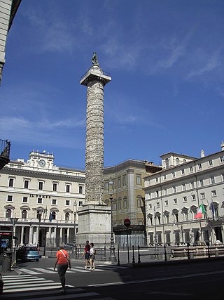
Colonna is the 3rd rione of Rome, Italy, identified by the initials R. III and located at the city's historic center in Municipio I. It takes its name from the Column of Marcus Aurelius in the Piazza Colonna, the rione's main square.

SantEustachio (<i>rione</i> of Rome) Rione of Rome in Lazio, Italy

Sant'Eustachio is the 8th rione of Rome, Italy, identified by the initials R. VIII. It is named after the eponymous church and is located within the Municipio I.

<span class="mw-page-title-main">Regola</span> Rione of Rome in Lazio, Italy

Regola is the 7th rione of Rome, Italy, identified by the initials R. VII, and belongs to the Municipio I. The name comes from Arenula, which was the name of the soft sand that the river Tiber left after the floods, and that built strands on the left bank.

Pigna (<i>rione</i> of Rome) Rione of Rome in Lazio, Italy

Pigna is the 9th rione of Rome, Italy, identified by the initials R. IX, and belongs to the Municipio I. The name means "pine cone" in Italian, and the symbol of the rione is the colossal bronze pine cone standing in the middle of the homonymous fountain. The fountain, which was initially located in the Baths of Agrippa, now decorates a vast niche in the wall of the Vatican facing the Cortile della Pigna, located in Vatican City.

<span class="mw-page-title-main">Campitelli</span> Rione of Rome in Lazio, Italy

Campitelli is the 10th rione of Rome, Italy, identified by the initials R. X, and is located in the Municipio I.

Ripa (<i>rione</i> of Rome) Rione of Rome in Lazio, Italy

Ripa is the 12th rione of Rome, Italy, identified by the initials R. XII, and it is located in the Municipio I.

Esquilino (<i>rione</i> of Rome) Rione of Rome in Lazio, Italy

Esquilino is the 15th rione, or administrative division, of Rome, Italy, identified by the initials R. XV, and is Located within the Municipio I. It is named after the Esquiline Hill, one of the Seven Hills of Rome.

<span class="mw-page-title-main">Sallustiano</span> Rione of Rome in Lazio, Italy

Sallustiano is the 17th rione of Rome, Italy, identified by the initials R. XVII. It is located within the Municipio I and the name refers to the ancient Gardens of Sallust, which were located here.

<span class="mw-page-title-main">Castro Pretorio</span> Rione of Rome in Lazio, Italy

Castro Pretorio is the 18th rione of Rome, Italy, identified by the initials R. XVIII, and it is located within the Municipio I. The rione takes its name by the ruins of the Castrum Praetorium, the barracks of the Praetorian Guard, included in the Aurelian Walls.

<span class="mw-page-title-main">Campo Marzio</span> Rione of Rome in Lazio, Italy

Campo Marzio is the 4th rione of Rome, Italy, identified by the initials R. IV. It belongs to the Municipio I and covers a smaller section of the area of the ancient Campus Martius. The logo of this rione is a silver crescent on a blue background.

<span class="mw-page-title-main">Churches of Rome</span>

There are more than 900 churches in Rome, which makes it the city with the largest number of churches in the world. Almost all of these are Catholic.

<span class="mw-page-title-main">Via del Corso</span> Thoroughfare in Rome, Italy

The Via del Corso is a main street in the historical centre of Rome. It is straight in an area otherwise characterized by narrow meandering alleys and small piazzas. Considered a wide street in ancient times, the Corso is approximately 10 metres wide, and it only has room for two lanes of traffic and two narrow sidewalks. The northern portion of the street is a pedestrian area. The length of the street is roughly 1.5 kilometres.

<span class="mw-page-title-main">Spagna (Rome Metro)</span> Rome metro station

Spagna is an underground station on Line A of the Rome Metro, in the rione Campo Marzio, which was inaugurated in 1980.

<span class="mw-page-title-main">Barberini – Fontana di Trevi</span> Rome metro station

Barberini–Fontana di Trevi is an underground station on Line A of the Rome Metro, inaugurated in 1980 and situated under Piazza Barberini in Trevi. Originally, the station was simply named Barberini, and the name was extended in 2000.

<span class="mw-page-title-main">National churches in Rome</span> Designation of certain churches in Rome

Charitable institutions attached to churches in Rome were founded right through the medieval period and included hospitals, hostels, and others providing assistance to pilgrims to Rome from a certain "nation", which thus became these nations' national churches in Rome. These institutions were generally organized as confraternities and funded through charity and legacies from rich benefactors belonging to that "nation". Often, they were also connected to national scholæ, where the clergymen of that nation were trained. The churches and their riches were a sign of the importance of their nation and of the prelates that supported them. Up to 1870 and Italian unification, these national churches also included churches of the Italian states.

<span class="mw-page-title-main">Outline of Rome</span> Overview of and topical guide to Rome

The following outline is provided as an overview of and topical guide to Rome:

References

  1. "Biblioteche ed i Centri specializzati." City of Rome. Retrieved on 8 September 2012.