Tropical rainforest climate

Last updated
Worldwide zones of tropical rainforest climate (Af). Koppen-Geiger Map Af present.svg
Worldwide zones of tropical rainforest climate (Af).

A tropical rainforest climate or equatorial climate is a tropical climate sub-type usually found within 10 to 15 degrees latitude of the equator. There are some other areas at higher latitudes, such as the coast of southeast Florida, United States, and Okinawa, Japan that fall into the tropical rainforest climate category. They experience high mean annual temperatures, small temperature ranges, and rain that falls throughout the year. Regions with this climate are typically designated Af by the Köppen climate classification. A tropical rainforest climate is typically hot, very humid, and wet with no dry season.

Contents

Description

Borneo, with the typical vegetation of tropical forests. Cloud forest mount kinabalu.jpg
Borneo, with the typical vegetation of tropical forests.
Amazon rainforest, Manaus, Brazil. Amazon Manaus forest.jpg
Amazon rainforest, Manaus, Brazil.

Tropical rainforests have a type of tropical climate in which there is no dry season—all months have an average precipitation value of at least 60 mm (2.4 in). There are no distinct wet or dry seasons as rainfall is high throughout the months. One day in a tropical rainforest climate can be very similar to the next, while the change in temperature between day and night may be larger than the average change in temperature during the year. [1]

Equatorial climates and tropical trade-wind climates

When tropical rainforest climates are more dominated by the Intertropical Convergence Zone (ITCZ) than the trade winds (and with no or rare cyclones), so usually located near the equator, they are also called equatorial climates. Otherwise, when they are more dominated by the trade winds than the ITCZ, they are called tropical trade-wind climates. In pure equatorial climates, the atmospheric pressure is almost constantly low so the horizontal pressure gradient is low. Consequently, the winds are rare and usually weak (except sea and land breezes in coastal areas) while in tropical trade-wind climates, often located at higher latitudes than the equatorial climates, the wind is almost permanent which incidentally explains why rainforest formations are impoverished compared to those of equatorial climates due to their necessary resistance to strong winds accompanying tropical disturbances. [2] [3]

Cities with tropical rainforest climates

Paramaribo, Suriname
Climate chart (explanation)
J
F
M
A
M
J
J
A
S
O
N
D
 
 
200
 
 
30
22
 
 
140
 
 
30
22
 
 
150
 
 
30
22
 
 
210
 
 
31
22
 
 
290
 
 
30
23
 
 
290
 
 
31
22
 
 
230
 
 
31
22
 
 
170
 
 
32
23
 
 
90
 
 
32
23
 
 
90
 
 
33
23
 
 
120
 
 
32
23
 
 
180
 
 
30
22
Average max. and min. temperatures in °C
Precipitation totals in mm
Source:
Imperial conversion
JFMAMJJASOND
 
 
7.9
 
 
86
72
 
 
5.5
 
 
86
72
 
 
5.9
 
 
86
72
 
 
8.3
 
 
88
72
 
 
11
 
 
86
73
 
 
11
 
 
88
72
 
 
9.1
 
 
88
72
 
 
6.7
 
 
90
73
 
 
3.5
 
 
90
73
 
 
3.5
 
 
91
73
 
 
4.7
 
 
90
73
 
 
7.1
 
 
86
72
Average max. and min. temperatures in °F
Precipitation totals in inches
Mbandaka, DR Congo
Climate chart (explanation)
J
F
M
A
M
J
J
A
S
O
N
D
 
 
80
 
 
31
19
 
 
100
 
 
32
20
 
 
150
 
 
32
20
 
 
140
 
 
31
20
 
 
130
 
 
31
20
 
 
110
 
 
30
19
 
 
100
 
 
30
17
 
 
100
 
 
29
17
 
 
200
 
 
30
19
 
 
210
 
 
30
19
 
 
190
 
 
30
19
 
 
120
 
 
30
19
Average max. and min. temperatures in °C
Precipitation totals in mm
Source:
Imperial conversion
JFMAMJJASOND
 
 
3.1
 
 
88
66
 
 
3.9
 
 
90
68
 
 
5.9
 
 
90
68
 
 
5.5
 
 
88
68
 
 
5.1
 
 
88
68
 
 
4.3
 
 
86
66
 
 
3.9
 
 
86
63
 
 
3.9
 
 
84
63
 
 
7.9
 
 
86
66
 
 
8.3
 
 
86
66
 
 
7.5
 
 
86
66
 
 
4.7
 
 
86
66
Average max. and min. temperatures in °F
Precipitation totals in inches
Pontianak, Indonesia
Climate chart (explanation)
J
F
M
A
M
J
J
A
S
O
N
D
 
 
260
 
 
32
23
 
 
215
 
 
33
23
 
 
254
 
 
33
23
 
 
292
 
 
33
23
 
 
256
 
 
33
23
 
 
212
 
 
33
23
 
 
201
 
 
33
22
 
 
180
 
 
33
23
 
 
295
 
 
33
23
 
 
329
 
 
33
23
 
 
400
 
 
32
23
 
 
302
 
 
32
22
Average max. and min. temperatures in °C
Precipitation totals in mm
Source:
Imperial conversion
JFMAMJJASOND
 
 
10
 
 
90
73
 
 
8.5
 
 
91
73
 
 
10
 
 
91
73
 
 
11
 
 
92
74
 
 
10
 
 
91
74
 
 
8.3
 
 
92
74
 
 
7.9
 
 
91
72
 
 
7.1
 
 
92
73
 
 
12
 
 
91
73
 
 
13
 
 
91
73
 
 
16
 
 
90
73
 
 
12
 
 
90
72
Average max. and min. temperatures in °F
Precipitation totals in inches
Kuching, Malaysia
Climate chart (explanation)
J
F
M
A
M
J
J
A
S
O
N
D
 
 
466
 
 
30
23
 
 
445
 
 
29
23
 
 
465
 
 
30
23
 
 
251
 
 
32
23
 
 
347
 
 
33
24
 
 
310
 
 
32
23
 
 
184
 
 
31
23
 
 
326
 
 
32
23
 
 
208
 
 
32
23
 
 
307
 
 
32
23
 
 
482
 
 
32
24
 
 
516
 
 
30
23
Average max. and min. temperatures in °C
Precipitation totals in mm
Source: Monthly Statistical Bulletin Sarawak
Imperial conversion
JFMAMJJASOND
 
 
18
 
 
87
73
 
 
18
 
 
84
74
 
 
18
 
 
87
73
 
 
9.9
 
 
90
74
 
 
14
 
 
91
74
 
 
12
 
 
89
73
 
 
7.2
 
 
88
74
 
 
13
 
 
89
73
 
 
8.2
 
 
90
74
 
 
12
 
 
89
74
 
 
19
 
 
89
74
 
 
20
 
 
87
74
Average max. and min. temperatures in °F
Precipitation totals in inches
Davao, Philippines
Climate chart (explanation)
J
F
M
A
M
J
J
A
S
O
N
D
 
 
140
 
 
31
23
 
 
109
 
 
31
23
 
 
108
 
 
32
24
 
 
125
 
 
33
24
 
 
159
 
 
33
25
 
 
187
 
 
32
24
 
 
165
 
 
32
24
 
 
170
 
 
32
24
 
 
170
 
 
32
24
 
 
175
 
 
32
24
 
 
138
 
 
32
24
 
 
113
 
 
31
24
Average max. and min. temperatures in °C
Precipitation totals in mm
Source:
Imperial conversion
JFMAMJJASOND
 
 
5.5
 
 
87
74
 
 
4.3
 
 
88
74
 
 
4.3
 
 
90
74
 
 
4.9
 
 
91
76
 
 
6.2
 
 
91
76
 
 
7.4
 
 
89
76
 
 
6.5
 
 
89
75
 
 
6.7
 
 
89
75
 
 
6.7
 
 
89
75
 
 
6.9
 
 
90
75
 
 
5.4
 
 
90
75
 
 
4.4
 
 
89
75
Average max. and min. temperatures in °F
Precipitation totals in inches
Quibdó, Colombia
Climate chart (explanation)
J
F
M
A
M
J
J
A
S
O
N
D
 
 
579
 
 
30
23
 
 
505
 
 
30
23
 
 
526
 
 
30
23
 
 
655
 
 
31
23
 
 
776
 
 
31
23
 
 
762
 
 
31
23
 
 
803
 
 
31
23
 
 
852
 
 
31
23
 
 
702
 
 
31
23
 
 
654
 
 
30
23
 
 
728
 
 
30
23
 
 
589
 
 
30
23
Average max. and min. temperatures in °C
Precipitation totals in mm
Source:
Imperial conversion
JFMAMJJASOND
 
 
23
 
 
86
73
 
 
20
 
 
86
74
 
 
21
 
 
87
74
 
 
26
 
 
87
74
 
 
31
 
 
88
74
 
 
30
 
 
88
73
 
 
32
 
 
88
73
 
 
34
 
 
88
73
 
 
28
 
 
87
73
 
 
26
 
 
87
73
 
 
29
 
 
86
73
 
 
23
 
 
85
73
Average max. and min. temperatures in °F
Precipitation totals in inches

See also

Related Research Articles

<span class="mw-page-title-main">Geography of Brunei</span>

Brunei is a country in Southeast Asia, bordering the South China Sea and East Malaysia. Its geographical coordinates are 4°30′N114°40′E. The country is small with a total size of 5,765 km2 (2,226 sq mi). It is larger in size than Trinidad and Tobago. It is close to vital sea lanes through the South China Sea linking the Indian and Pacific Oceans. The country has two parts physically separated by Malaysia, making it almost an enclave within Malaysia.

<span class="mw-page-title-main">Temperate climate</span> Main climate class

In geography, the temperate climates of Earth occur in the middle latitudes, which span between the tropics and the polar regions of Earth. These zones generally have wider temperature ranges throughout the year and more distinct seasonal changes compared to tropical climates, where such variations are often small and usually only have precipitation differences.

<span class="mw-page-title-main">Tropics</span> Region of Earth surrounding the Equator

The tropics are the regions of Earth surrounding the Equator. They are defined in latitude by the Tropic of Cancer in the Northern Hemisphere at 23°26′10.1″ (or 23.43613°) N and the Tropic of Capricorn in the Southern Hemisphere at 23°26′10.1″ (or 23.43613°) S. The tropics are also referred to as the tropical zone and the torrid zone.

<span class="mw-page-title-main">Mediterranean climate</span> Type of climate

A Mediterranean climate, also called a dry summer climate, described by Köppen as Cs, is a temperate climate type that occurs in the lower mid-latitudes. Such climates typically have dry summers and wet winters, with summer conditions ranging from warm to hot and winter conditions typically being mild to cool. These weather conditions are typically experienced in the majority of Mediterranean-climate regions and countries, but remain highly dependent on proximity to the ocean, altitude and geographical location.

<span class="mw-page-title-main">Subtropics</span> Geographic and climate zone

The subtropical zones or subtropics are geographical and climate zones to the north and south of the tropics. Geographically part of the temperate zones of both hemispheres, they cover the middle latitudes from 23°26′10.1″ (or 23.43614°) to approximately 35° north and south. The horse latitudes lie within this range.

<span class="mw-page-title-main">Intertropical Convergence Zone</span> Meteorological phenomenon

The Intertropical Convergence Zone, known by sailors as the doldrums or the calms because of its monotonous windless weather, is the area where the northeast and the southeast trade winds converge. It encircles Earth near the thermal equator though its specific position varies seasonally. When it lies near the geographic Equator, it is called the near-equatorial trough. Where the ITCZ is drawn into and merges with a monsoonal circulation, it is sometimes referred to as a monsoon trough.

<span class="mw-page-title-main">Tropical climate</span> One of the five major climate groups in the Köppen climate classification

Tropical climate is the first of the five major climate groups in the Köppen climate classification identified with the letter A. Tropical climates are defined by a monthly average temperature of 18 °C (64.4 °F) or higher in the coolest month, and feature hot temperatures all year-round. Annual precipitation is often abundant in tropical climates, and shows a seasonal rhythm but may have seasonal dryness to varying degrees. There are normally only two seasons in tropical climates, a wet (rainy/monsoon) season and a dry season. The annual temperature range in tropical climates is normally very small. Sunlight is intense in these climates.

<span class="mw-page-title-main">Köppen climate classification</span> Climate classification system

The Köppen climate classification is one of the most widely used climate classification systems. It was first published by German-Russian climatologist Wladimir Köppen (1846–1940) in 1884, with several later modifications by Köppen, notably in 1918 and 1936. Later, German climatologist Rudolf Geiger (1894–1981) introduced some changes to the classification system in 1954 and 1961, which is thus sometimes called the Köppen–Geiger climate classification.

<span class="mw-page-title-main">Semi-arid climate</span> Climate with precipitation below potential evapotranspiration

A semi-arid climate, semi-desert climate, or steppe climate is a dry climate sub-type. It is located on regions that receive precipitation below potential evapotranspiration, but not as low as a desert climate. There are different kinds of semi-arid climates, depending on variables such as temperature, and they give rise to different biomes.

<span class="mw-page-title-main">Dry season</span> Yearly period of low rainfall, especially in the tropics

The dry season is a yearly period of low rainfall, especially in the tropics. The weather in the tropics is dominated by the tropical rain belt, which moves from the northern to the southern tropics and back over the course of the year. The temperate counterpart to the tropical dry season is summer or winter.

Rainfall and the tropical climate dominate the tropical rain belt, which oscillates from the northern to the southern tropics over the course of the year, roughly following the solar equator. The tropical rain belt is an area of active rain that is positioned mostly around the tropics.

<span class="mw-page-title-main">Convergence zone</span> Region in the atmosphere

A convergence zone in meteorology is a region in the atmosphere where two prevailing flows meet and interact, usually resulting in distinctive weather conditions. This causes a mass accumulation that eventually leads to a vertical movement and to the formation of clouds and precipitation. Large-scale convergence, called synoptic-scale convergence, is associated with weather systems such as baroclinic troughs, low-pressure areas, and cyclones. The large-scale convergence zone formed over the equator, the Intertropical Convergence Zone, has condensed and intensified as a result of the global increase in temperature. Small-scale convergence will give phenomena from isolated cumulus clouds to large areas of thunderstorms.

<span class="mw-page-title-main">Geography of South America</span> Overview of the geography of South America

The geography of South America contains many diverse regions and climates. Geographically, South America is generally considered a continent forming the southern portion of the landmass of the Americas, south and east of the Colombia–Panama border by most authorities, or south and east of the Panama Canal by some. South and North America are sometimes considered a single continent or supercontinent, while constituent regions are infrequently considered subcontinents.

A tropical marine climate is a tropical climate that is primarily influenced by the ocean. It is usually experienced by islands and coastal areas 10° to 20° north and south of the equator. There are two main seasons in a tropical marine climate: the wet season and the dry season. The annual rainfall is 1000 to over 1500 mm. The temperature ranges from 20 °C to 35 °C. Under the Köppen climate classification, a "tropical marine climate" would fall under Af or Am, tropical rainforest or tropical monsoon climate. The trade winds blow all year round and are moist, as they pass over warm seas. These climatic conditions are found, for example, across the Caribbean, the eastern coasts of Brazil, Madagascar and Queensland; and many islands in tropical waters.

<span class="mw-page-title-main">Climate classification</span> Systems that categorize the worlds climates

Climate classifications are systems that categorize the world's climates. A climate classification may correlate closely with a biome classification, as climate is a major influence on life in a region. One of the most used is the Köppen climate classification scheme first developed in 1884.

<span class="mw-page-title-main">Tropical savanna climate</span> Climate subtype

Tropical savanna climate or tropical wet and dry climate is a tropical climate sub-type that corresponds to the Köppen climate classification categories Aw and As. The driest month has less than 60 mm (2.4 in) of precipitation and also less than mm of precipitation.

<span class="mw-page-title-main">Tropical monsoon climate</span> Climate subtype in the Köppen climate classification system

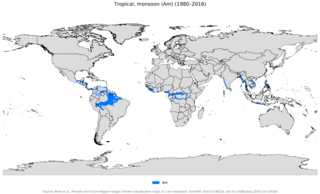
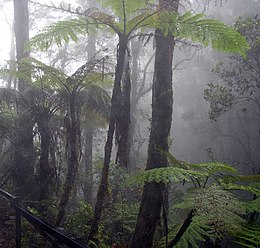
An area of tropical monsoon climate is a tropical climate subtype that corresponds to the Köppen climate classification category Am. Tropical monsoon climates have monthly mean temperatures above 18 °C (64 °F) in every month of the year and a dry season. The tropical monsoon climate is the intermediate climate between the wet AF and the drier Aw.

The Tropical Atlantic Variability (TAV) is influenced by internal interaction and external effects. TAV can be discussed in different time scales: seasonal and interannual. tav can be discussed in different time scales:seasonal and interannual.and external effects.

<span class="mw-page-title-main">Seasonal tropical forest</span> Type of tropical forest

Seasonal tropical forest, also known as moist deciduous, semi-evergreen seasonal, tropical mixed or monsoon forest, typically contains a range of tree species: only some of which drop some or all of their leaves during the dry season. This tropical forest is classified under the Walter system as (i) tropical climate with high overall rainfall and (ii) having a very distinct wet season with dry season. These forests represent a range of habitats influenced by monsoon (Am) or tropical wet savannah (Aw/As) climates. Drier forests in the Aw climate zone are typically deciduous and placed in the Tropical dry forest biome: with further transitional zones (ecotones) of savannah woodland then tropical and subtropical grasslands, savannas, and shrublands.

<span class="mw-page-title-main">Highland temperate climate</span>

The highland temperate climates are a temperate climate sub-type, although located in tropical zone, isothermal and with characteristics different from others temperate climates like oceanic or mediterranean where they are often are included without proper differentiation.

References

  1. McKnight, Tom L; Hess, Darrel (2000). "Climate Zones and Types". Physical Geography: A Landscape Appreciation. Upper Saddle River, NJ: Prentice Hall. pp.  205–8. ISBN   978-0-13-020263-5.
  2. Climatologie Pierre Estienne Alain Godard, pages 309 and 316
  3. Seidel, Dian J.; Fu, Qiang; Randel, William J.; Reichler, Thomas J. (January 2008). "Widening of the tropical belt in a changing climate". Nature Geoscience. 1 (1): 21–24. Bibcode:2008NatGe...1...21S. doi:10.1038/ngeo.2007.38. ISSN   1752-0908.