Troy, Idaho

Last updated

Troy, Idaho
Troy Idaho aerial, May 2023.png
Aerial view of Troy from the southeast
Latah County Idaho Incorporated and Unincorporated areas Troy Highlighted 1682360.svg
Location of Troy in Latah County, Idaho.
Coordinates: 46°44′19″N116°46′15″W / 46.73861°N 116.77083°W / 46.73861; -116.77083
Country United States
State Idaho
County Latah
Area
[1]
  Total0.79 sq mi (2.05 km2)
  Land0.79 sq mi (2.05 km2)
  Water0.00 sq mi (0.00 km2)
Elevation
2,487 ft (758 m)
Population
 (2010) [2]
  Total862
  Estimate 
(2019) [3]
895
  Density1,131.48/sq mi (436.77/km2)
Time zone UTC-8 (Pacific (PST))
  Summer (DST) UTC-7 (PDT)
ZIP code
83871
Area code 208
FIPS code 16-82360
GNIS feature ID0400145
Website www.troyidaho.net

Troy is a city in Latah County, Idaho, United States. Located in the eastern part of the Palouse region, its population was 862 at the 2010 census.

Contents

South entrance to Troy Troy Idaho.jpg
South entrance to Troy

History

The community was originally known as Huffs Gulch when J. Wesley Seat homesteaded in the area in 1885. In 1890, area businessman John P. Vollmer rechristened the area with his own surname when he brought the railroad through. Vollmer gained much of his 30,000 acres (47 sq mi; 120 km2) of land by foreclosing on the bank loans of local farmers. This made him so unpopular that in 1897 the residents decided to rename the town. Local legend states that the name Troy was selected when a Greek railroad worker offered free shots of whiskey to any who would support the name. [4]

Geography

According to the United States Census Bureau, the city has a total area of 0.79 square miles (2.05 km2), all of it land. [5]

Demographics

Historical population
CensusPop.Note
1900 283
1910 54391.9%
1920 5918.8%
1930 6194.7%
1940 580−6.3%
1950 531−8.4%
1960 5554.5%
1970 541−2.5%
1980 82051.6%
1990 699−14.8%
2000 79814.2%
2010 8628.0%
2019 (est.)895 [3] 3.8%
U.S. Decennial Census [6]

2020 census estimates

As of the census [7] estimates of 2020, Troy had a population of 895 people (53 of which are recognized military veterans)(an observed 12.2% increase since 2000) and 321 housing units in the city's boundaries. 85.8% of residents are expected to have a broadband Internet subscription, 98.8% of current residents are estimated to have completed education at the high-school level or higher, and just 2.4% of the population are predicted to be living without health insurance. [7] The median resident age is 34.6 years, slightly lower than the statewide median age of 36.9 years.

2010 census

As of the census [2] of 2010, there were 862 people, 324 households, and 242 families residing in the city. The population density was 1,091.1 inhabitants per square mile (421.3/km2). There were 355 housing units at an average density of 449.4 per square mile (173.5/km2). The racial makeup of the city was 96.1% White, 0.2% Native American, 0.6% Asian, 0.5% from other races, and 2.7% from two or more races. Hispanic or Latino of any race were 3.0% of the population.

There were 324 households, of which 38.6% had children under the age of 18 living with them, 63.9% were married couples living together, 5.6% had a female householder with no husband present, 5.2% had a male householder with no wife present, and 25.3% were non-families. 20.4% of all households were made up of individuals, and 8.4% had someone living alone who was 65 years of age or older. The average household size was 2.66 and the average family size was 3.10.

The median age in the city was 37.9 years. 29% of residents were under the age of 18; 5.1% were between the ages of 18 and 24; 28.4% were from 25 to 44; 26.1% were from 45 to 64; and 11.4% were 65 years of age or older. The gender makeup of the city was 49.8% male and 50.2% female.

2000 census

As of the census [8] of 2000, there were 798 people, 309 households, and 224 families residing in the city. The population density was 1,004.8 inhabitants per square mile (388.0/km2). There were 341 housing units at an average density of 429.4 per square mile (165.8/km2). The racial makeup of the city was 96.12% White, 0.50% Native American, 0.38% Asian, and 3.01% from two or more races. Hispanic or Latino of any race were 0.13% of the population.

There were 309 households, out of which 38.5% had children under the age of 18 living with them, 61.2% were married couples living together, 7.8% had a female householder with no husband present, and 27.2% were non-families. 20.7% of all households were made up of individuals, and 7.8% had someone living alone who was 65 years of age or older. The average household size was 2.58 and the average family size was 3.02.

In the city, the population was spread out, with 29.8% under the age of 18, 7.1% from 18 to 24, 29.2% from 25 to 44, 22.4% from 45 to 64, and 11.4% who were 65 years of age or older. The median age was 34 years. For every 100 females, there were 99.5 males. For every 100 females age 18 and over, there were 92.4 males.

The median income for a household in the city was $36,250, and the median income for a family was $42,031. Males had a median income of $33,194 versus $23,295 for females. The per capita income for the city was $16,557. About 11.9% of families and 12.1% of the population were below the poverty line, including 14.7% of those under age 18 and 3.1% of those age 65 or over.

Education

Public education is provided by the Troy School District (#287); [9] the current high school is combined with the junior high and opened in 2003; the previous building dated back to 1906. [10] The Trojans compete in athletics in the White Pine League in IHSAA Class 1A (Div I). [11]

Infrastructure

For bicyclists and pedestrians, the Latah Trail is a paved rail trail near Highway 8 that connects Troy to Moscow and Pullman, Washington. It meets the Paradise Path in Moscow, which continues west as the Bill Chipman Palouse Trail to Pullman alongside Highway 270; the total length of the three trails from Troy to Pullman is 22 miles (35 km). Access to the trail in Troy is permitted at the west corner of Troy City Park.

Notable people

John H. HaysMedal of Honor recipient and town marshal killed in action in 1904. [12]

Related Research Articles

<span class="mw-page-title-main">Moscow, Idaho</span> City in northern Idaho, United States

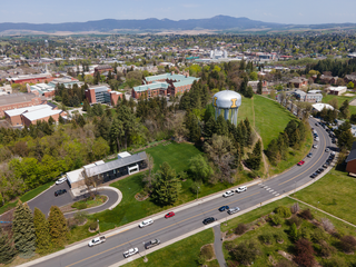
Moscow is a city and the county seat of Latah County, Idaho. Located in the North Central region of the state along the border with Washington, it had a population of 25,435 at the 2020 census. Moscow is the home of the University of Idaho, the state's land-grant institution and primary research university.

<span class="mw-page-title-main">Nez Perce County, Idaho</span> County in Idaho, United States

Nez Perce County is a county located in the U.S. state of Idaho. As of the 2020 census, the population was 42,090. The county seat is Lewiston. The county is named after the Native American Nez Percé tribe. Nez Perce County is part of the Lewiston, Idaho–WA Metropolitan Statistical Area.

<span class="mw-page-title-main">Whitman County, Washington</span> County in Washington, United States

Whitman County is a county located in the U.S. state of Washington. As of the 2020 census, the population was 47,973. The county seat is Colfax, and its largest city is Pullman.

<span class="mw-page-title-main">Shoshone County, Idaho</span> County in Idaho, United States

Shoshone County is a county in the U.S. state of Idaho. As of the 2020 census, the population was 13,169. The county seat is Wallace and the largest city is Kellogg. The county was established in 1864, named for the Native American Shoshone tribe.

<span class="mw-page-title-main">Latah County, Idaho</span> County in Idaho, United States

Latah County is a county located in the north central region of the U.S. state of Idaho. As of the 2020 census, the population was 39,517. The county seat and largest city is Moscow, the home of the University of Idaho, the state's flagship university.

<span class="mw-page-title-main">Clearwater County, Idaho</span> County in Idaho, United States

Clearwater County is a county located in the U.S. state of Idaho. As of the 2020 census, the population was 8,734. The county seat is Orofino. Established in 1911, the county was named after the Clearwater River.

<span class="mw-page-title-main">Plummer, Idaho</span> City in Idaho, United States

Plummer is a city in Benewah County, Idaho, United States. The population was 1,044 at the 2010 census, up from 990 in 2000. It is the largest city within the Coeur d'Alene Reservation, and is accessed by U.S. Route 95, the state's primary north–south highway.

<span class="mw-page-title-main">Tensed, Idaho</span> City in Idaho, United States

Tensed is a city in Benewah County, Idaho, United States. The population was 123 at the 2010 census, down from 126 in 2000. The city is within the Coeur d'Alene Reservation, and is accessed by U.S. Route 95, the state's primary north-south highway. The city is located about 1 mile (0.6 km) from the north entrance of McCroskey State Park.

<span class="mw-page-title-main">Soda Springs, Idaho</span> City in the United States

Soda Springs is a city in Caribou County, Idaho, United States. Its population was 3,058 at the time of the 2010 census. The city has been the county seat of Caribou County since the county was organized in 1919. In the 1860s, Soda Springs served as the seat of Oneida County.

<span class="mw-page-title-main">Albion, Idaho</span> City in Idaho, United States

Albion is a city in Cassia County, Idaho, United States. It is part of the Burley, Idaho Micropolitan Statistical Area. The population was 234 at the 2020 census. Albion was the county seat of Cassia County from 1879 to 1918.

<span class="mw-page-title-main">Elk River, Idaho</span> City in Idaho, United States

Elk River is a city in the northwestern United States in Clearwater County, Idaho. The population was 125 at the 2010 census, down from 156 in 2000. It is accessed from State Highway 8 from Bovill, to the west in adjacent Latah County. Formerly the site of a Potlatch sawmill, it was phased out after several decades during the 1930s.

<span class="mw-page-title-main">Bovill, Idaho</span> City in Idaho, United States

Bovill is a city in Latah County, Idaho, United States. The population was 260 at the 2010 census, down from 305 in 2000.

<span class="mw-page-title-main">Deary, Idaho</span> City in Idaho, United States

Deary is a city in Latah County, Idaho. The population was 506 at the time of the 2010 census, down from 552 in 2000. It is located 24 miles (39 km) east of Moscow and 43 miles (69 km) northeast of Lewiston.

<span class="mw-page-title-main">Genesee, Idaho</span> City in Idaho, United States

Genesee is a city in Latah County, Idaho, United States. The population was 955 at the 2010 census, up from 946 in 2000. The city was named for the Genesee region of western New York, although it may also be a modification of the biblical Genesis.

<span class="mw-page-title-main">Juliaetta, Idaho</span> Town in Idaho, United States

Juliaetta is a city in Latah County, Idaho, United States. The population was 624 at the 2020 census.

<span class="mw-page-title-main">Kendrick, Idaho</span> City in Idaho, United States

Kendrick is a city in Latah County, Idaho, United States. Its population was 303 at the 2010 census, a decrease from 369 in 2000.

<span class="mw-page-title-main">Onaway, Idaho</span> City in Idaho, United States

Onaway is a city in Latah County, Idaho, United States. The population was 187 at the 2010 census, down from 230 in 2000.

<span class="mw-page-title-main">Potlatch, Idaho</span> City in Idaho, United States

Potlatch is a city in the northwest United States, located in north central Idaho in Latah County, about six miles (10 km) east of the border with Washington. On the Palouse north of Moscow, it is served by State Highway 6, and bordered on the northeast by the small community of Onaway. The population of Potlatch was 804 at the 2010 census.

<span class="mw-page-title-main">Latah, Washington</span> Town in Washington, United States

Latah is a town in Spokane County, Washington, United States. The population was 183 at the 2010 census. It was named for the nearby creek, Latah Creek, from the native word for fish. The town was formerly called, Hangman's Creek and Alpha.

<span class="mw-page-title-main">Pullman, West Virginia</span> Town in West Virginia, United States

Pullman is a town in Ritchie County, West Virginia, United States. The population was 134 at the 2020 census.

References

  1. "2019 U.S. Gazetteer Files". United States Census Bureau. Retrieved July 9, 2020.
  2. 1 2 "U.S. Census website". United States Census Bureau . Retrieved December 18, 2012.
  3. 1 2 "Population and Housing Unit Estimates". United States Census Bureau. May 24, 2020. Retrieved May 27, 2020.
  4. Monroe, Julie (2006). Images of America:Latah County. Arcadia Publishing. p. 99. ISBN   0738531332.
  5. "US Gazetteer files 2010". United States Census Bureau. Archived from the original on January 25, 2012. Retrieved December 18, 2012.
  6. "Census of Population and Housing". Census.gov. Retrieved June 4, 2015.
  7. 1 2 Bureau, US Census. "Search Results". The United States Census Bureau. Retrieved March 29, 2021.
  8. "U.S. Census website". United States Census Bureau . Retrieved January 31, 2008.
  9. "Welcome". Troy School District. Retrieved October 19, 2017.
  10. Bacharach, Alexis (September 29, 2003). "Troy dedicates new high school". Moscow-Pullman Daily News. (Idaho-Washington). p. 1A.
  11. "Welcome". White Pine League. (Idaho). Retrieved October 19, 2017.
  12. Special Dispatch to the Chronicle (January 28, 1904). "SHOOTS DOWN AN OFFICER: A Drunken Wife Beater Becomes a Murderer in Resisting Arrest at Troy, Idaho FIGHTS DUEL WITH THE TOWN MARSHAL His Lust for Blood Not Having Subsided, He Begins a Promiscuous Fusillade, but Is Quickly Forced to Surrender". San Francisco Chronicle. ProQuest   573397568 . Retrieved March 29, 2021.