
Troy is a city in Lincoln County, Montana, United States. The population was 797 at the 2020 census. It lies at the lowest elevation of any settlement in Montana. The town is on U.S. Route 2, near Montana Highway 56, in the Kootenai River gorge by the Kootenai National Forest.

Crown Point is a basalt promontory on the Columbia River Gorge and an associated state park in the U.S. state of Oregon. It is located in eastern Multnomah County, approximately 15 miles (24 km) east of Portland. Crown Point is one of the scenic lookouts along the Historic Columbia River Highway, providing a panoramic view of part of the Columbia River. It stands 733 feet (223 m) above the river and is the remains of a lava flow that filled the ancestral channel of the Columbia River 14 to 17 million years ago. The Point was designated a National Natural Landmark in 1971.

Big Hole National Battlefield preserves a battlefield in the western United States, located in Beaverhead County, Montana. In 1877, the Nez Perce fought a delaying action against the U.S. Army's 7th Infantry Regiment here on August 9 and 10, during their failed attempt to escape to Canada. This action, the Battle of the Big Hole, was the largest battle fought between the Nez Perce and U.S. Government forces in the five-month conflict known as the Nez Perce War.

Pompeys Pillar National Monument is a rock formation located in south central Montana, United States. Designated a national monument on January 17, 2001, and managed by the U.S. Bureau of Land Management in conjunction with The Friends of Pompeys Pillar, it consists of only 51 acres (21 ha), making it one of the smallest National Monuments in the U.S. The community of Pompeys Pillar lies just east of the monument.

This is a list of properties and historic districts in Montana that are listed on the National Register of Historic Places. The state's more than 1,100 listings are distributed across all of its 56 counties.

Camp Disappointment is the northernmost campsite of the Lewis and Clark Expedition, on its return trip from the Pacific Northwest. The site is on private land within the Blackfeet Indian Reservation in Glacier County, Montana. It is located along the south bank of Cut Bank Creek and 12 miles (19 km) northeast of Browning, Montana. Glacier National Park can be seen in the distance.

Traveler's Rest was a stopping point of the Lewis and Clark Expedition, located about one mile south of Lolo, Montana. The expedition stopped from September 9 to September 11, 1805, before crossing the Bitterroot Mountains, and again on the return trip from June 30 to July 3, 1806. Traveler's Rest is at the eastern end of the Lolo Trail. It was declared a National Historic Landmark in 1960 and added to the National Register of Historic Places in 1966. The boundaries were subsequently revised, and mostly lie within the 51-acre (21 ha) Traveler's Rest State Park, which is operated by the Montana Fish, Wildlife & Parks. Significant archeological findings made in 2002, including latrine sites with traces of mercury and fire hearths, make this the only site on the Lewis and Clark National Historic Trail that has yielded physical proof of the explorers' presence. Records made by Lewis and Clark often spell "Traveler's" as "Traveller's". This spot is largely unchanged from the days of Lewis and Clark. From this location, Lewis and Clark split up to explore Montana during their return trip, not reuniting until they reached Sanish, North Dakota.
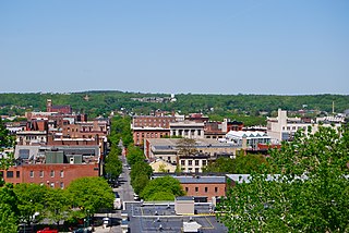
The Central Troy Historic District is an irregularly shaped, 96-acre (39 ha) area of downtown Troy, New York, United States. It has been described as "one of the most perfectly preserved 19th-century downtowns in the [country]" with nearly 700 properties in a variety of architectural styles from the early 19th to mid-20th centuries. These include most of Russell Sage College, one of two privately owned urban parks in New York, and two National Historic Landmarks. Visitors ranging from the Duke de la Rochefoucauld to Philip Johnson have praised aspects of it. Martin Scorsese used parts of downtown Troy as a stand-in for 19th-century Manhattan in The Age of Innocence.

This is a list of the National Register of Historic Places listings in Ravalli County, Montana.

The Lewis and Clark Bridge is a historic bridge in Wolf Point, Montana, which once carried Montana Highway 13 across the Missouri River between McCone and Roosevelt counties. It is also known as Wolf Point Bridge, Missouri River Bridge, or Site No. 24RV438. The bridge is a five-span Pennsylvania through truss; its longest span is the longest through truss span in the state at 400-foot (120 m). Completed in 1930 by the Missouri Valley Bridge and Iron Company, the bridge was the first bridge across the Missouri River at Wolf Point and the only bridge along the river for a 350-mile (560 km) stretch. The bridge's opening ceremony, which took place on July 9, drew over 10,000 visitors and included five bands and a fireworks display. After its completion, the bridge became a popular tourist attraction for motorists in northeastern Montana and a point of civic pride for Wolf Point's residents.

This is a list of the National Register of Historic Places listings in Yellowstone County, Montana. It is intended to be a complete list of the properties and districts on the National Register of Historic Places in Yellowstone County, Montana, United States. The locations of National Register properties and districts for which the latitude and longitude coordinates are included below, may be seen in a map.

This is a list of the National Register of Historic Places listings in Chouteau County, Montana. It is intended to be a complete list of the properties and districts on the National Register of Historic Places in Chouteau County, Montana, United States. The locations of National Register properties and districts for which the latitude and longitude coordinates are included below, may be seen in a map.

The Gleim Building, 265 W. Front St., Missoula, Montana, was a brothel constructed in 1893 for Mary Gleim, a notorious madam who owned at least eight "female boarding houses". This building serves as an example of a vernacular adaptation of Romanesque architecture.

The Ismay Jail is a National Registered Historic Place located in Ismay, Montana. It was added to the Register on June 4, 1997.

The Theodore Roosevelt Memorial Bridge is a steel bridge located in Troy, Montana, USA. It was listed on the National Register of Historic Places on December 27, 2006.

Kelly's Camp is a small district of vacation cabins on the west shore of Lake McDonald in Glacier National Park, Montana, USA. Kelly's Camp consists of twelve log buildings along the western shore of the lake. The structures were notable for being one of the most extensive summer cabin enclaves remaining in the park. Early reports following the advance of the Howe Ridge Fire on August 12, 2018 are that nine or ten structures have been destroyed.
The Stone Jail Building and Row House are two adjacent stone buildings located on Water Street in Tonopah, Nevada. The jail was built in 1903 and the adjacent row house in 1908. Both building were at one time used as a brothel. The buildings were added to the National Register of Historic Places in 1982.
The Skullyville County Jail, located west of Panama in Le Flore County, Oklahoma, was built in 1907. It was listed on the National Register of Historic Places in 1980.

The Sanders County Jail is a historic jail built in 1907 in Thompson Falls in Sanders County, Montana. It was listed on the National Register of Historic Places in 1986.


