Tshikota | |
|---|---|
 Tshikota  Tshikota | |
| Coordinates: 23°03′04″S29°52′08″E / 23.051°S 29.869°E Coordinates: 23°03′04″S29°52′08″E / 23.051°S 29.869°E | |
| Country | South Africa |
| Province | Limpopo |
| District | Vhembe |
| Municipality | Makhado |
| Area | |
| • Total | 2.37 km2 (0.92 sq mi) |
| Population (2011) [1] | |
| • Total | 7,492 |
| • Density | 3,200/km2 (8,200/sq mi) |
| Racial makeup (2011) | |
| • Black African | 98.5% |
| • Coloured | 1.3% |
| • Indian/Asian | 0.1% |
| • White | 0.1% |
| • Other | 0.1% |
| First languages (2011) | |
| • Venda | 54.6% |
| • Northern Sotho | 13.3% |
| • Tsonga | 6.8% |
| • Sotho | 5.4% |
| • Other | 19.9% |
| Time zone | UTC+2 (SAST) |
Tshikota is a township just west outside Louis Trichardt in Vhembe District Municipality in the Limpopo province of South Africa.
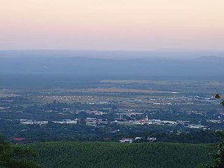
Louis Trichardt is a town at the foot of Songozwi, in the Soutpansberg mountain range in the Limpopo province of South Africa. It is named after the voortrekker leader Louis Tregardt; the original Venda name is Tshirululuni, and it is also informally known as Tshitandani. The whole region was known as Dzanani until 1946. It is the centre of the Makhado Local Municipality, which comprises 16,000 km² with a total population of 270,000 (2001). Louis Trichardt is located in a fertile region where litchis, bananas, mangoes and nuts are produced. The national road N1 runs through the town. Louis Trichardt is 437 kilometres from Johannesburg and one hour's drive from the Zimbabwean border at Beitbridge. Louis Trichardt was formerly known as Makhado, but it was changed back to Louis Trichardt. But now many people use the one name or the other. Vleifontein, Elim, Tshikota, Madombidzha, Makhado Park and Dzanani surround the town at all directions.
Vhembe is one of the 5 districts of Limpopo province of South Africa. It is the northernmost district of the country and shares its northern border with Beitbridge district in Matabeleland South, Zimbabwe and on the east with Gaza Province in Mozambique. Vhembe consist of all territories that were part of the former Venda Bantustan, however, two large densely populated districts of the former Tsonga homeland of Gazankulu, in particular, Hlanganani and Malamulele were also incorporated into Vhembe, hence the ethnic diversity of the District. The seat of Vhembe is Thohoyandou, the former Capital of the former Venda Bantustan. According to 2011 census, the majority of Vhembe residents, about 800 000, speak TshiVenda as their mother language, while 400 000 speak Xitsonga as their home language. However, the Tsonga people are in majority south of Levubu River and they constitute more than 85% of the population in the south of the historic river Levubu, while the Venda are in Minority south of Levubu, at 15%. The Northern Sotho speakers stands at 27 000. The district code is DC34.

Limpopo is the northernmost province of South Africa. It is named after the Limpopo River, which forms the province's western and northern borders. The name "Limpopo" has its etymological origin in the Northern Sotho language word diphororo tša meetse, meaning "strong gushing waterfalls". The capital is Polokwane.
