Tsuen Wan

Last updated

Tsuen Wan
荃灣
Tsuen Wan Skyline 2010.jpg
The day scene of Tsuen Wan across Rambler Channel (View taken from Tsing Yi Island)
Coordinates: 22°22′07″N114°06′47″E / 22.36861°N 114.11306°E / 22.36861; 114.11306
RegionFlag of Hong Kong.svg  Hong Kong
Area
  Total60.7 km2 (23.4 sq mi)
Population
 (2006)
  Total288,728
  Density4,800/km2 (12,000/sq mi)

History

Night scene of Tsuen Wan taken near Belvedere Gardens Estate. To the left is Nina Tower TsuenWan atNight.jpg
Night scene of Tsuen Wan taken near Belvedere Gardens Estate. To the left is Nina Tower
Commercial area in Chung On Street, Tsuen Wan HK Tsuen Wan Night Chung On Street 47 a.jpg
Commercial area in Chung On Street, Tsuen Wan
Jockey Club Tak Wah Park Tak Wah Park 201106.jpg
Jockey Club Tak Wah Park
Chai Wan Kok HK Tsuen Wan Chai Wan Kok Industrial Area.jpg
Chai Wan Kok
Tsuen Wan Plaza Tsuen Wan Plaza Main Void 201405.jpg
Tsuen Wan Plaza
Tsuen Wan (Bottom Right), Tsing Yi and Kwai Chung Tsuen Wan, Tsing Yi and Kwai Chung.jpg
Tsuen Wan (Bottom Right), Tsing Yi and Kwai Chung

According to the report of Hong Kong archaeological society, people settled in Tsuen Wan as early as 2,000 years ago. In earlier days, it was known as Tsin Wan (淺灣) which means shallow bay, and later renamed to Tsuen Wan. Another name Tsak Wan (賊灣, Hakka dialect pronunciation: tshet wan), pirate bay, indicates the presence of pirates nearby long ago. In fact, the area around Rambler Channel was known as Sam Pak Tsin (三百錢), literally meaning three hundred coins. There was a legend that pirates would collect three hundred coins should one pass through the area.

In 1911, there were approximately 3,000 villagers living in Tsuen Wan. In the 20th century, factories moved in gradually due to its proximity to Kowloon. With the construction of Castle Peak Road in 1917, motor vehicles could reach the town in addition to access on foot and by boat. Regular bus services did not begin until 1933. Early industries relied on the ample local water supply to make incense sticks, preserved fruit and farming, while post-war industries included metal wares and textiles. By 1950s, Tsuen Wan had become the centre of the textile industry in Hong Kong. [1]

In the 1950s, the Hong Kong Government developed the area as a satellite town, along with Kwun Tong satellite town in Eastern Kowloon. In 1961, Tsuen Wan Satellite Town was expanded to become Tsuen Wan New Town, the first of such in Hong Kong. The new town covers not only Tsuen Wan, but also neighbouring Kwai Chung and Tsing Yi, including housing estates like the Fuk Loi Estate, built in 1967. [1] By 1971, the area housed 400,000 residents. It was one of the last areas in Hong Kong to be developed without the "Colony Outline Plan". [2] A museum of a local settlement village is located in Tsuen Wan Town: Sam Tung Uk Museum. The museum consists of a 200-year-old walled village featuring exhibits designed to replicate traditional village life. It was donated in 1981 and after restoration during the construction of the MTR, it was opened for the public in 1987.

Tsuen Wan has one of the highest concentrations of Shanghainese people in Hong Kong, particularly in the constituency Fuk Loi. [3]

Landmarks

Discovery Park, one of Hong Kong's largest shopping centres, is located in the heart of Tsuen Wan Town. There is a goldsmith street there where jewels can be purchased. Other features include Tsuen Wan Plaza, Tsuen Wan City Landmark, Citywalk and L'Hotel, The Sam Tung Uk Museum, Tin Hau Temple and The Panda Hotel, one of the biggest hotels in Hong Kong. The Nina Towers, which include an 80-storey tower, rise over Tsuen Wan. Hong Kong's cable TV service company i-CABLE also has their headquarters located in Tsuen Wan at Wharf Cable Tower.

Situated in the valley, floodplain and reclaimed land, Tsuen Wan is surrounded on two sides by hills and woodlands that make up the Shing Mun Country Park and the Tai Mo Shan Country Park. Located within these parks are the Tai Mo Shan peak, the highest point in Hong Kong at 957 metres (3,140 feet), and the Upper Shing Mun Reservoir. Route Twisk winds over and through the country parks linking Tsuen Wan with Pat Heung, via Shek Kong. Originally built by the Royal Engineers as a military road, it was opened to the public on 25 May 1961.

An urban renewal project led to the shopping malls Citywalk and Citywalk 2, as well as the residential areas above it.

The former Tsuen Wan Sports Ground, on Yeung Uk Road, was demolished and replaced by the Shing Mun Valley Sports Ground. The site, now known as Tsuen Wan Town Lot 393, remains abandoned, but was sold by the government for nearly HK$4 billion in 2014 to Vincord Limited. [4]

Housing

Public housing estates

Private housing estates

Allway Gardens Allway.jpg
Allway Gardens

Private housing estates in Tsuen Wan include:

Economy

Chinachem has its head office in Nina Tower in Tsuen Wan. [6]

Education

Tsuen Wan is in Primary One Admission (POA) School Net 62, [7] which includes schools in Tsuen Wan and areas nearby. The net includes multiple aided schools and one government school, Hoi Pa Street Government Primary School. [8]

Public transport

Tai Ho Road Tai Ho Road.jpg
Tai Ho Road

Trains

Tsuen Wan is served by three Mass Transit Railway (MTR) stations: Tsuen Wan station and Tai Wo Hau station on the Tsuen Wan line, as well as Tsuen Wan West station on the Tuen Ma line.

Ferries

The Tsuen Wan Pier connects Tsuen Wan to Park Island, a private housing estate in Ma Wan. [9]

Buses

The Tsuen Wan Transport Complex was once a major interchange point between ferries and buses. It was rendered obsolete when land reclamation moved the adjacent ferry pier, and when ferry services were scaled back following the opening of the MTR.

Tsuen Wan is still well-served by many bus routes. There are major bus termini at Tsuen Wan and Tsuen Wan West railway stations, and at some private developments like Nina Tower and Allway Gardens. There are also many minibuses to major destinations around Hong Kong.

See also

Related Research Articles

<span class="mw-page-title-main">Tsing Yi</span> Island in Hong Kong

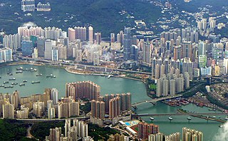
Tsing Yi, sometimes referred to as Tsing Yi Island, is an island in the urban area of Hong Kong, to the northwest of Hong Kong Island and south of Tsuen Wan. With an area of 10.69 km2 (4.13 sq mi), the island has been extended drastically by reclamation along almost all its natural shore and the annexation of Nga Ying Chau (牙鷹洲) and Chau Tsai. Three major bays or harbours, Tsing Yi Lagoon, Mun Tsai Tong and Tsing Yi Bay (青衣灣) in the northeast, have been completely reclaimed for new towns.

<span class="mw-page-title-main">Tsuen Wan District</span> District in Hong Kong, China

Tsuen Wan District is one of the 18 districts of Hong Kong. It is located in the New Territories and is served by the Tsuen Wan line of the MTR metro system. Its area is 60.7 km2. Its residents, who mostly live in Tsuen Wan Town, enjoy the highest income in the New Territories.

Hong Kong counts approximately 600 temples, shrines and monasteries. While Buddhism and Christianity are the most widely practiced religions, most religions are represented in the Special Administrative Region.

<span class="mw-page-title-main">Tung Chung</span> New town in Hong Kong

Tung Chung, meaning "eastern stream", is an area on the northwestern coast of Lantau Island, Hong Kong. One of the most recent new towns, it was formerly a rural fishing village beside Tung Chung Bay, and along the delta and lower courses of Tung Chung River and Ma Wan Chung in the north-western coast of Lantau Island. The area was once an important defence stronghold against pirates and foreign military during the Ming and the Qing dynasties.

<span class="mw-page-title-main">Tai Wai</span> Area in the New Territories, Hong Kong

Tai Wai is an area in the New Territories, Hong Kong, located between Sha Tin and the Lion Rock, within the Sha Tin District.

<span class="mw-page-title-main">Sheung Shui</span> Area of Hong Kong

Sheung Shui is an area in the New Territories, Hong Kong. Sheung Shui Town, a part of this area, is part of the Fanling–Sheung Shui New Town in the North District of Hong Kong. Fanling Town is to its southeast.

<span class="mw-page-title-main">Lei Yue Mun</span> Short channel in Hong Kong

Lei Yue Mun is a short channel in Hong Kong. It lies between Junk Bay and Victoria Harbour, separating Kowloon and Hong Kong Island. The channel is an important passage for the city, forming the eastern entrance of Victoria Harbour.

<span class="mw-page-title-main">Sha Tin</span> Neighbourhood in Hong Kong, China

Sha Tin, also spelt Shatin, is a neighbourhood along Shing Mun River in the eastern New Territories, Hong Kong. Administratively, it is part of the Sha Tin District. Sha Tin is one of the neighbourhoods of the Sha Tin New Town project.

<span class="mw-page-title-main">Ma Liu Shui</span> Place in New Territories, Hong Kong

Ma Liu Shui is an area in Sha Tin District, in the New Territories, Hong Kong.

<span class="mw-page-title-main">Tuen Mun</span> Area in the New Territories, Hong Kong

Tuen Mun or Castle Peak is an area near the mouth of Tuen Mun River and Castle Peak Bay in the New Territories, Hong Kong. It was one of the earliest settlements in what is now Hong Kong and can be dated to the Neolithic period. In the more recent past, it was home to many Tanka fishermen who gathered at Castle Peak Bay. Tuen Mun is now a modern, mainly residential area in the north-west New Territories. As of 2011, 487,546 live in Tuen Mun and over 95% of them are Chinese.

<span class="mw-page-title-main">Tsing Lung Tau</span> Coastal residential area in Hong Kong

Tsing Lung Tau is a coastal residential area in the southwest coast of the New Territories in Hong Kong.

<span class="mw-page-title-main">Chai Wan Kok</span> Area in Tsuen Wan, Hong Kong

Chai Wan Kok is an area in Tsuen Wan, Hong Kong. It is located at the west end of Tsuen Wan Town. While its southeast is industrial area, its hilly northeast and coastal southwest are residential. It is on the main access between Tuen Mun and Tsuen Wan.

Articles related to Hong Kong include:

<span class="mw-page-title-main">Tsuen Wan Pier</span>

Tsuen Wan Pier, Tsuen Wan Ferry or Tsuen Wan Ferry Pier is a public pier at the south of Tsuen Wan, New Territories, Hong Kong, which is adjacent to the MTR Tsuen Wan West station. It provided ferry service to Central via Tsing Yi, but the service ceased operation in 2000 after Western Harbour Crossing and MTR Tung Chung line were commissioned to provide faster route between New Territories West and Hong Kong Island.

<span class="mw-page-title-main">Skyline Plaza (Hong Kong)</span> Building in Tsuen Wan, Hong Kong

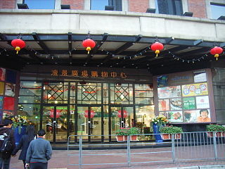
Skyline Plaza is a private housing estate and shopping mall in Tsuen Wan, Hong Kong. It is close to the Tsuen Wan Town Hall, Tsuen Wan Ferry Pier, Nina Tower and MTR Tsuen Wan West station. It was developed by the Henderson Land Development in April 1995.

<span class="mw-page-title-main">Tai Wo Hau</span>

Tai Wo Hau is a place in Tsuen Wan across Tsuen Wan District and Kwai Tsing District. Its area mainly includes Tai Wo Hau Estate, Kwai Yin Court, Kwai Yung Court, and private buildings along Texaco Road. It also includes Kwok Shui Road at the north of Castle Peak Road.

The following is a list of public housing estates in Tsuen Wan, Hong Kong, including Home Ownership Scheme (HOS), Private Sector Participation Scheme (PSPS), Sandwich Class Housing Scheme (SCHS), Flat-for-Sale Scheme (FFSS), and Tenants Purchase Scheme (TPS) estates.

<span class="mw-page-title-main">Tsuen Wan Transport Complex</span> Building in Tsuen Wan, Hong Kong

Tsuen Wan Transport Complex was a large transport hub in Tsuen Wan, Hong Kong. There was a bus terminus and taxi stand on the ground floor; on top sat a multi-storey car park.

References

  1. 1 2 http://cd1.edb.hkedcity.net/cd/TC/Content_4025/Changes_in_Tsuen_Wan/frame.htm HK Ed City. Urban Development in Tsuen Wan. Retrieved 18 Sept 2012.
  2. Buckley, Roger. [1997] (1997). Hong Kong: The Road to 1997 By Roger Buckley. Cambridge University Press. ISBN   0-521-46979-1
  3. The Routledge Handbook of Spanish in the Global City. Routledge. 11 July 2019. ISBN   9781317506744.
  4. "Tenders awarded for two residential sites". Hong Kong Government. 13 August 2014. Retrieved 5 August 2015.
  5. (in Chinese) Allway Gardens official homepage Retrieved 2011-09-17
  6. "Contact Us". Chinachem . Retrieved 29 December 2020. Head Office 35-38/F, Nina Tower, 8 Yeung Uk Road, Tsuen Wan, New Territories
  7. "POA2023 Primary School Lists by School Net for Discretionary Places Admission Stage". Education Bureau . Retrieved 13 September 2022.
  8. "POA School Net 62" (PDF). Education Bureau . Retrieved 12 September 2022.
  9. "Ferry Services of Park Island". pitcl.com.hk. Archived from the original on 16 June 2008.

Further reading

Tsuen Wan
Traditional Chinese 荃灣
Simplified Chinese 荃湾