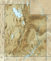
Washington County is a county in the southwestern corner of Utah, United States. As of the 2020 United States Census, the population was 180,279, making it the fifth-most populous county in Utah. Its county seat and largest city is St. George. The county was created in 1852 and organized in 1856. It was named after the first President of the United States, George Washington. A portion of the Paiute Indian Reservation is in western Washington County. Washington County comprises the St. George, UT Metropolitan Statistical Area.

Thomas Moran was an American painter and printmaker of the Hudson River School in New York whose work often featured the Rocky Mountains. Moran and his family, wife Mary Nimmo Moran and daughter Ruth took residence in New York where he obtained work as an artist. He was a younger brother of the noted marine artist Edward Moran, with whom he shared a studio. A talented illustrator and exquisite colorist, Thomas Moran was hired as an illustrator at Scribner's Monthly. During the late 1860s, he was appointed the chief illustrator for the magazine, a position that helped him launch his career as one of the premier painters of the American landscape, in particular, the American West.

The Colorado Plateau, also known as the Colorado Plateau Province, is a physiographic and desert region of the Intermontane Plateaus, roughly centered on the Four Corners region of the southwestern United States. This province covers an area of 336,700 km2 (130,000 mi2) within western Colorado, northwestern New Mexico, southern and eastern Utah, northern Arizona, and a tiny fraction in the extreme southeast of Nevada. About 90% of the area is drained by the Colorado River and its main tributaries: the Green, San Juan, and Little Colorado. Most of the remainder of the plateau is drained by the Rio Grande and its tributaries.
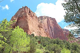
Horse Ranch Mountain is an 8,733-foot (2,662 m) mountain in the Kolob Canyons section of Zion National Park in northeastern Washington County, Utah, United States, that is the highest summit within the national park. It rises above Camp Creek to the north and Taylor Creek to the south. Its neighbors include Tucupit Point, 1 mi (1.6 km) to the south, and Timber Top Mountain is situated 3.9 mi (6.3 km) to the south-southwest.

Zion National Park is an American national park located in southwestern Utah near the town of Springdale. Located at the junction of the Colorado Plateau, Great Basin, and Mojave Desert regions, the park has a unique geography and a variety of life zones that allow for unusual plant and animal diversity. Numerous plant species as well as 289 species of birds, 75 mammals, and 32 reptiles inhabit the park's four life zones: desert, riparian, woodland, and coniferous forest. Zion National Park includes mountains, canyons, buttes, mesas, monoliths, rivers, slot canyons, and natural arches. The lowest point in the park is 3,666 ft (1,117 m) at Coalpits Wash and the highest peak is 8,726 ft (2,660 m) at Horse Ranch Mountain. A prominent feature of the 229-square-mile (590 km2) park is Zion Canyon, which is 15 miles (24 km) long and up to 2,640 ft (800 m) deep. The canyon walls are reddish and tan-colored Navajo Sandstone eroded by the North Fork of the Virgin River.

Colburn's Butte, South Utah is an watercolor painting by the American artist Thomas Moran, created in 1873. Done in watercolor, gouache, and graphite on wove paper, the work depicts Tucupit Point in the Kolob Canyons, Zion National Park.
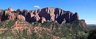
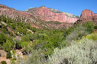
Timber Top Mountain is an 8,055-foot (2,455 m) mountain summit located in the Kolob Canyons section of Zion National Park, in Washington County, Utah, United States. Its nearest higher neighbor is Horse Ranch Mountain, 3.9 mi (6.3 km) to the north-northeast, Nagunt Mesa is immediately north, and Tucupit Point is situated 2.8 mi (4.5 km) to the north. Timber Top Mountain is the second-highest peak in Zion Park, following only Horse Ranch Mountain. Walls of Navajo sandstone encircle this mesa-like feature, ranging from 400-ft high on along the south side, up to 2,000 feet on the north aspect. Kolob Arch is set on the lower southeast cliff of the mountain, and Shuntavi Butte forms the west tip of the mountain. Precipitation runoff from the mountain drains into Timber Creek, which is within the Virgin River drainage basin.

Nagunt Mesa is a 7,785-foot (2,373 m) mountain summit located in the Kolob Canyons area of Zion National Park in Washington County, Utah, United States.

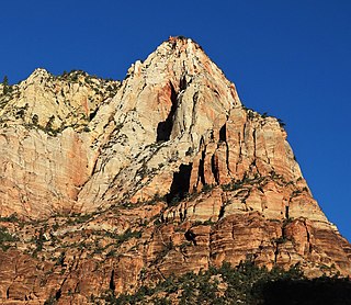
The Sentinel is a 7,120+ ft elevation Navajo Sandstone summit located near the Court of the Patriarchs in Zion National Park, in Washington County of southwest Utah, United States, that is part of the Towers of the Virgin. The national park map lists the elevation as 7,157-feet.
Lady Mountain is a 6,945-foot (2,117 m) elevation Navajo Sandstone summit located in Zion National Park, in Washington County of southwest Utah, United States.

Tabernacle Dome is a 6,430-foot elevation summit located in Zion National Park, in Washington County of southwest Utah, United States. Tabernacle Dome, a formation composed of Navajo Sandstone, is situated at the southeastern end of Cave Valley, 10 mi (16 km) northwest of Springdale, Utah. Its nearest higher neighbor is Cave Knoll, 1.6 mi (3 km) to the north-northwest. Other neighbors include South Guardian Angel, 1.9 mi (3 km) to the east, and North Guardian Angel, 2.2 mi (4 km) to the northeast. Precipitation runoff from this mountain drains into tributaries of the Virgin River. Access to this peak is via the Kolob Terrace Road. This peak's name was officially adopted in 1934 by the U.S. Board on Geographic Names. It is named for its resemblance to the Mormon Tabernacle in Salt Lake City.

Paria Point is a 7,802-foot (2,378 m) elevation summit located in the Kolob Canyons section of Zion National Park, in Washington County, Utah, United States. Tucupit Point is situated 0.5 mi (0.80 km) immediately north, and Beatty Point is 0.5 mi (0.80 km) immediately south, with 2,000-foot-deep finger canyons between each. Other neighbors include Nagunt Mesa and Timber Top Mountain to the south, and Horse Ranch Mountain to the north. Paria Point is composed of Jurassic Navajo sandstone overlaying tilted Kayenta Formation. Precipitation runoff drains into Taylor Creek, which is part of the Virgin River drainage basin. This feature's paria name is a Paiute word meaning "muddy water" or "elk water".

Beatty Point is a 7,780-foot (2,370 m) elevation summit located in the Kolob Canyons area of Zion National Park in Washington County, Utah, United States.

Smithsonian Butte is a 6,780-foot (2,070 m) elevation summit located in the Canaan Mountain Wilderness of Washington County in southwest Utah, United States.

Eagle Crags is a 6,380-foot (1,940 m) elevation summit located in the Canaan Mountain Wilderness of Washington County in southwest Utah, United States.
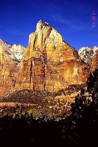
Isaac Peak is a 6,726-foot (2,050 m) rock formation in Zion National Park in Washington County, Utah, United States. Access to Isaac Peak is from the main Park road through Sand Beach Trail. Isaac Peak is part of the Three Patriarchs in between Abraham Peak and Jacob Peak. Between Isaac Peak and Abraham Peak is Isaac Canyon, accessed by climbing up the South Fork of Heaps Canyon.

Aires Butte is a 6,492-foot (1,979 m) summit located in Zion National Park, in Washington County of southwest Utah, United States. It is composed of white Navajo Sandstone, and rises 1,100-foot (340-meter) above the Zion – Mount Carmel Highway. Aires Butte is situated 0.9 mi (1.4 km) east-northeast of Ant Hill, 1.5 mi (2.4 km) north of Nippletop, and 1.9 mi (3.1 km) northwest of Checkerboard Mesa. Precipitation runoff from this mountain drains into tributaries of the Virgin River.
Jacob Peak is a 6,873-foot (2,095 m) rock formation in Zion National Park in Washington County, Utah, United States. Jacob Peak is part of the Three Patriarchs, along with Abraham Peak and Isaac Peak.