The Green River Formation is an Eocene geologic formation that records the sedimentation in a group of intermountain lakes in three basins along the present-day Green River in Colorado, Wyoming, and Utah. The sediments are deposited in very fine layers, a dark layer during the growing season and a light-hue inorganic layer in the dry season. Each pair of layers is called a varve and represents one year. The sediments of the Green River Formation present a continuous record of six million years. The mean thickness of a varve here is 0.18 mm, with a minimum thickness of 0.014 mm and maximum of 9.8 mm.
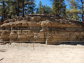
The Florissant Formation is a sedimentary geologic formation outcropping around Florissant, Teller County, Colorado. The formation is noted for the abundant and exceptionally preserved insect and plant fossils that are found in the mudstones and shales. Based on argon radiometric dating, the formation is Eocene in age and has been interpreted as a lake environment. The fossils have been preserved because of the interaction of the volcanic ash from the nearby Thirtynine Mile volcanic field with diatoms in the lake, causing a diatom bloom. As the diatoms fell to the bottom of the lake, any plants or animals that had recently died were preserved by the diatom falls. Fine layers of clays and muds interspersed with layers of ash form "paper shales" holding beautifully-preserved fossils. The Florissant Fossil Beds National Monument is a national monument established to preserve and study the geology and history of the area.

The West Elk Mountains are a high mountain range in the west-central part of the U.S. state of Colorado. They lie primarily within the Gunnison National Forest, and part of the range is protected as the West Elk Wilderness. The range is primarily located in Gunnison County, with small parts in eastern Delta and Montrose counties.

The Laramie Formation is a geologic formation of the Late Cretaceous (Maastrichtian) age, named by Clarence King in 1876 for exposures in northeastern Colorado, in the United States. It was deposited on a coastal plain and in coastal swamps that flanked the Western Interior Seaway. It contains coal, clay and uranium deposits, as well as plant and animal fossils, including dinosaur remains.

The Hamilton Group is a Devonian-age geological group which is located in the Appalachian region of the United States. It is present in New York, Pennsylvania, Maryland, Ohio, West Virginia, northwestern Virginia and Ontario, Canada, and is mainly composed of marine shale with some sandstone.

The Marcellus Formation or the Marcellus Shale is a Middle Devonian age unit of sedimentary rock found in eastern North America. Named for a distinctive outcrop near the village of Marcellus, New York, in the United States, it extends throughout much of the Appalachian Basin.

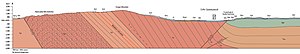
Simi Valley is a synclinal valley in Southern California in the United States. It is an enclosed or hidden valley surrounded by mountains and hills. It is connected to the San Fernando Valley to the east by the Santa Susana Pass and the 118 freeway, and in the west the narrows of the Arroyo Simi and the Reagan Freeway connection to Moorpark. The relatively flat bottom of the valley contains soils formed from shales, sandstones, and conglomerates eroded from the surrounding hills of the Santa Susana Mountains to the north, which separate Simi Valley from the Santa Clara River Valley, and the Simi Hills.

The Sespe Formation is a widespread fossiliferous sedimentary geologic unit in southern and south central California in the United States. It is of nonmarine origin, consisting predominantly of sandstones and conglomerates laid down in a riverine, shoreline, and floodplain environment between the upper Eocene Epoch through the lower Miocene. It is often distinctive in appearance, with its sandstones weathering to reddish-brown, maroon, pinkish-gray, tan, and green. Since many of its sandstones are more resistant to erosion than many other regional sedimentary units it often forms dramatic outcrops and ridgelines in many local mountain ranges.

The island of Taiwan was formed approximately 4 to 5 million years ago at a convergent boundary between the Philippine Sea Plate and the Eurasian Plate. In a boundary running the length of the island and continuing southwards, the Eurasian Plate is sliding under the Philippine Sea Plate. In the northeast of the island, the Philippine Sea Plate slides under the Eurasian Plate. Most of the island comprises a huge fault block tilted to the west.

The Fayetteville Shale is a geologic formation of Mississippian age composed of tight shale within the Arkoma Basin of Arkansas and Oklahoma. It is named for the city of Fayetteville, Arkansas, and requires hydraulic fracturing to release the natural gas contained within.

Tomichi Dome rises north of U.S. Highway 50 west of Hot Springs Creek and south of Waunita Hot Springs Reservoir in the southeast quarter of Gunnison County, Colorado. It is situated within the Gunnison National Forest.

The La Meseta Formation is a sedimentary sequence deposited during the Eocene on Seymour Island off the coast of the Antarctic Peninsula. It is noted for its fossils, which include both marine organisms and the only terrestrial vertebrate fossils from the Cenozoic of Antarctica.
The Nanjemoy Formation is a geologic formation pertaining to both the Wilcox Group and the Pamunkey Group of the eastern United States, stretching across the states of Virginia, Maryland, and District of Columbia. The formation crops out east of the Appalachians and dates back to the Paleogene period. Specifically to the Ypresian stage of the Eocene epoch, about 55 to 50 Ma or Wasatchian in the NALMA classification, defined by the contemporaneous Wasatch Formation of the Pacific US coast.

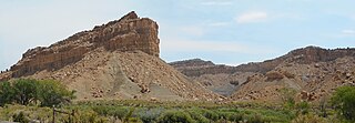
The Wasatch Formation (Tw) is an extensive highly fossiliferous geologic formation stretching across several basins in Idaho, Montana Wyoming, Utah and western Colorado. It preserves fossils dating back to the Early Eocene period. The formation defines the Wasatchian or Lostcabinian, a period of time used within the NALMA classification, but the formation ranges in age from the Clarkforkian to Bridgerian.
The Ferron Sandstone Member of the Mancos Shale is a geologic unit in Utah. It preserves fossils dating back to the Cretaceous period; and more specifically the middle Turonian.
The Cowlitz Formation is a geologic formation in Washington (state). It preserves fossils dating back to the Paleogene period

The Puget Group is a geologic group in Washington (state). It preserves fossils dating back to the Paleogene period.
The Coldwater Beds are a geologic formation of the Okanagan Highlands in British Columbia, Canada. They preserve fossils dating back to the Ypresian stage of the Eocene period, or Wasatchian in the NALMA classification.
The geology of the Northern Mariana Islands began to form with undersea volcanic eruptions in the Eocene. Islands such as Saipan show a variety of rock types including volcanic rocks, breccia, tuff, conglomerate, sandstone, clay and extensive limestones.
The paleofauna of the Eocene Okanagan Highlands consists of Early Eocene arthropods, vertebrates, plus rare nematodes and molluscs found in geological formations of the northwestern North American Eocene Okanagan Highlands. The highlands lake bed series' as a whole are considered one of the great Canadian Lagerstätten. The paleofauna represents that of a late Ypresian upland temperate ecosystem immediately after the Paleocene-Eocene thermal maximum, and before the increased cooling of the middle and late Eocene to Oligocene. The fossiliferous deposits of the region were noted as early as 1873, with small amounts of systematic work happening in the 1880-90s on British Columbian sites, and 1920-30s for Washington sites. Focus and more detailed descriptive work on the Okanagan Highlands site started in the last 1970's. Most of the highlands sites are preserved as compression-impression fossils in "shales", but also includes a rare permineralized biota and an amber biota.