Tullos, Louisiana

Last updated

Tullos, Louisiana
Town
Town of Tullos
LaSalle Parish Louisiana Incorporated and Unincorporated areas Tullos Highlighted.svg
Location in LaSalle Parish, Louisiana
Louisiana in United States (US48).svg
Location of Louisiana in the United States
Coordinates: 31°49′10″N92°19′39″W / 31.81944°N 92.32750°W / 31.81944; -92.32750
CountryUnited States
StateLouisiana
Parishes La Salle, Winn
Area
[1]
  Total1.60 sq mi (4.16 km2)
  Land1.58 sq mi (4.10 km2)
  Water0.02 sq mi (0.05 km2)
Elevation
125 ft (38 m)
Population
 (2020)
  Total304
  Density191.92/sq mi (74.10/km2)
Time zone UTC-6 (CST)
  Summer (DST) UTC-5 (CDT)
ZIP code
71479
Area code 318
FIPS code 22-76615

Tullos is a town in LaSalle and Winn parishes in the U.S. state of Louisiana, along Castor Creek. The population was 385 at the 2010 census. [2]

Contents

Geography

Tullos is located in northwestern LaSalle Parish at 31°49′10″N92°19′39″W / 31.81944°N 92.32750°W / 31.81944; -92.32750 (31.819556, -92.327501) [3] and has an elevation of 125 feet (38.1 m). [4] The northwest border of the town briefly crosses Castor Creek into Winn Parish.

U.S. Route 84 passes through the north side of the town, leading southeast 16 miles (26 km) to Jena, the parish seat, and northwest 22 miles (35 km) to Winnfield. U.S. Route 165, a four-lane divided highway, passes through the southeast corner of Tullos, leading northeast 20 miles (32 km) to Grayson and south 42 miles (68 km) to Alexandria.

According to the United States Census Bureau, Tullos has a total area of 1.6 square miles (4.2 km2), of which 0.02 square miles (0.05 km2), or 1.27%, are water. [5] Via Castor Creek, Tullos is part of the Little River watershed, flowing south and southeast to Catahoula Lake.

1953 tornado

On December 3, 1953, a violent F4 tornado hit the town, causing tremendous damage. Two small children were killed, and 15 others were injured. [6] [7] [8]

Demographics

Historical population
CensusPop.Note
1930 707
1940 589−16.7%
1950 73224.3%
1960 594−18.9%
1970 6001.0%
1980 77629.3%
1990 427−45.0%
2000 419−1.9%
2010 385−8.1%
2020 304−21.0%
U.S. Decennial Census [9]

As of the census [10] of 2000, there were 419 people, 168 households, and 113 families residing in the town. The population density was 278.5 inhabitants per square mile (107.5/km2). There were 203 housing units at an average density of 134.9 units per square mile (52.1 units/km2). The racial makeup of the town was 95.70% White, 3.34% African American, and 0.95% from two or more races. Hispanic or Latino of any race were 0.48% of the population.

There were 168 households, out of which 31.5% had children under the age of 18 living with them, 57.1% were married couples living together, 6.0% had a female householder with no husband present, and 32.7% were non-families. 27.4% of all households were made up of individuals, and 14.3% had someone living alone who was 65 years of age or older. The average household size was 2.49 and the average family size was 3.06.

In the town, the population was spread out, with 25.1% under the age of 18, 7.2% from 18 to 24, 27.2% from 25 to 44, 25.3% from 45 to 64, and 15.3% who were 65 years of age or older. The median age was 37 years. For every 100 females, there were 94.0 males. For every 100 females age 18 and over, there were 93.8 males.

The median income for a household in the town was $26,484, and the median income for a family was $31,786. Males had a median income of $24,896 versus $22,143 for females. The per capita income for the town was $14,265. About 13.8% of families and 18.3% of the population were below the poverty line, including 27.7% of those under age 18 and 12.0% of those age 65 or over.

Notable person

Related Research Articles

<span class="mw-page-title-main">LaSalle Parish, Louisiana</span> Parish in Louisiana, United States

LaSalle Parish is a parish located in the U.S. state of Louisiana. As of the 2020 United States Census, the population was 14,791. The parish seat is Jena. The parish was created in 1910 from the western section of Catahoula Parish.

<span class="mw-page-title-main">Jackson Parish, Louisiana</span> Parish in Louisiana, United States

Jackson Parish is a parish in the northern part of the U.S. state of Louisiana. As of the 2020 census, the population was 15,031. The parish seat is Jonesboro. The parish was formed in 1845 from parts of Claiborne, Ouachita, and Union Parishes. In the twentieth century, this part of the state had several small industrial mill towns, such as Jonesboro.

<span class="mw-page-title-main">Grant Parish, Louisiana</span> Parish in Louisiana, United States

Grant Parish is a parish located in the North Central portion of the U.S. state of Louisiana. As of the 2020 census, the population was 22,169. The parish seat is Colfax. The parish was founded in 1869 during the Reconstruction era.

<span class="mw-page-title-main">Bienville Parish, Louisiana</span> Parish in Louisiana, United States

Bienville Parish is a parish located in the northwestern portion of the U.S. state of Louisiana. At the 2020 census, the population was 12,981. The parish seat and most populous municipality is Arcadia.

<span class="mw-page-title-main">Falkville, Alabama</span> Town in Alabama, United States

Falkville is a town in Morgan County, Alabama, United States, and is included in the Decatur Metropolitan Area and Huntsville-Decatur Combined Statistical Area. As of the 2020 census, the population of the town was 1,197.

<span class="mw-page-title-main">Oberlin, Louisiana</span> Town in Louisiana, United States

Oberlin is a town in and the parish seat of Allen Parish, Louisiana, United States. The population was 1,770 at the 2010 census. The town is named after Johann Friedrich Oberlin.

<span class="mw-page-title-main">Dry Prong, Louisiana</span> Village in Louisiana, United States

Dry Prong is a village in central Grant Parish, Louisiana, United States. It is part of the Alexandria, Louisiana Metropolitan Statistical Area. The population was 436 at the 2010 census.

<span class="mw-page-title-main">Georgetown, Louisiana</span> Village in Louisiana, United States

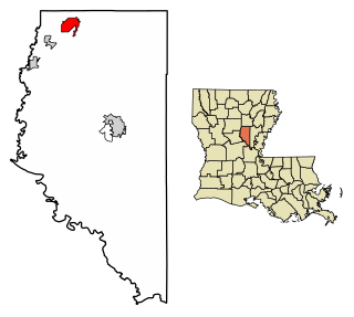
Georgetown is a village in Grant Parish, Louisiana, United States. It is part of the Alexandria, Louisiana Metropolitan Statistical Area. The population was 327 at the 2010 census.

<span class="mw-page-title-main">Montgomery, Louisiana</span> Town in Louisiana, United States

Montgomery is a town in the far northwestern portion of Grant Parish, which is located in north-central Louisiana, United States. The population of Montgomery was 726 at the 2010 census. The town has a poverty rate of 37 percent and a median household income of just under $22,000. The median age is just under forty; the population in 2010 was 78 percent white.

Midway is an unincorporated community and census-designated place (CDP) in LaSalle Parish, Louisiana, United States. The population was 1,291 at the 2010 census, down from 1,505 at the 2000 census.

<span class="mw-page-title-main">Olla, Louisiana</span> Town in Louisiana, United States

Olla is a town in northwest La Salle Parish, Louisiana, United States, located in the heart of the Louisiana Central Hill Country.

<span class="mw-page-title-main">Urania, Louisiana</span> Town in Louisiana, United States

Urania is a town in La Salle Parish, Louisiana United States. The population was 1,313 at the 2010 census.

<span class="mw-page-title-main">Scott, Louisiana</span> City in Louisiana, United States

Scott is the fourth largest municipality in Lafayette Parish, Louisiana, United States. The population was 8,614 as of the 2010 U.S. census, and 8,119 at the 2020 census, up from 7,870 at the 2000 census. Scott is a suburban community of Lafayette and is part of the Lafayette metropolitan statistical area in Acadiana.

<span class="mw-page-title-main">Boyce, Louisiana</span> Town in Louisiana, United States

Boyce is a town in northern Rapides Parish, Louisiana, United States. It is part of the Alexandria, Louisiana Metropolitan Statistical Area. The population was 888 at the 2020 census. The community is nearly 70 percent African American.

<span class="mw-page-title-main">Forest Hill, Louisiana</span> Village in Louisiana, United States

Forest Hill is a village in Rapides Parish, Louisiana, United States. It is part of the Alexandria, Louisiana Metropolitan Statistical Area. The population was placed at 605 according to the 2020 census.

<span class="mw-page-title-main">Kaplan, Louisiana</span> City in Louisiana, United States

Kaplan is a city in Vermilion Parish, Louisiana, United States. The population was 4,600 at the 2010 census, and 4,345 at the 2020 population estimates program. It is part of the Abbeville micropolitan statistical area in Acadiana.

<span class="mw-page-title-main">Atlanta, Louisiana</span> Village in Louisiana, United States

Atlanta is a village in Winn Parish, Louisiana, United States. The population was 163 at the 2010 census, and had been 150 in 2000.

<span class="mw-page-title-main">Calvin, Louisiana</span> Village in Louisiana, United States

Calvin is a village in Winn Parish, Louisiana, United States. The population was 236 at the 2000 census.

<span class="mw-page-title-main">Dodson, Louisiana</span> Village in Louisiana, United States

Dodson is a village in Winn Parish, Louisiana, United States. The population was 357 at the 2000 census, which decreased to 337 in 2010.

<span class="mw-page-title-main">Sikes, Louisiana</span> Village in Louisiana, United States

Sikes is a village in Winn Parish, Louisiana, United States. The population was 121 at the 2000 census.

References

  1. "2020 U.S. Gazetteer Files". United States Census Bureau. Retrieved March 20, 2022.
  2. "Total Population: 2010 Census DEC Summary File 1 (P1), Tullos town, Louisiana". data.census.gov. U.S. Census Bureau. Retrieved February 14, 2020.
  3. "US Gazetteer files: 2010, 2000, and 1990". United States Census Bureau. February 12, 2011. Retrieved April 23, 2011.
  4. "US Board on Geographic Names". United States Geological Survey. October 25, 2007. Retrieved January 31, 2008.
  5. "U.S. Gazetteer Files: 2019: Places: Louisiana". U.S. Census Bureau Geography Division. Retrieved February 14, 2020.
  6. Grazulis, Thomas (July 1993). Significant Tornadoes 1680–1991: A Chronology and Analysis of Events. St. Johnsbury, Vermont: The Tornado Project of Environmental Films. p. 976. ISBN   1-879362-03-1.
  7. "Louisiana Event Report: F4 Tornado". NCDC. National Climatic Data Center. Retrieved July 2, 2020.
  8. "Leander, Tullos, LA Tornado Damage, Dec 1953 | GenDisasters ... Genealogy in Tragedy, Disasters, Fires, Floods". www.gendisasters.com.
  9. "Census of Population and Housing". Census.gov. Retrieved June 4, 2015.
  10. "U.S. Census website". United States Census Bureau . Retrieved January 31, 2008.