Humboldt County is a county located in the U.S. state of California. As of the 2020 census, the population was 136,463. The county seat is Eureka.

Arcata is a city adjacent to the Arcata Bay (northern) portion of Humboldt Bay in Humboldt County, California, United States. At the 2020 census, Arcata's population was 18,857. Arcata was first colonized in 1850 as Union, was officially established in 1858, and was renamed Arcata in 1860. It is located 280 miles (450 km) north of San Francisco, and is home to California State Polytechnic University, Humboldt. Arcata is also the location of the Arcata Field Office of the Federal Bureau of Land Management, which is responsible for the administration of natural resources, lands and mineral programs, including the Headwaters Forest, on approximately 200,000 acres (810 km2) of public land in Northwestern California.
Eureka is the principal city and county seat of Humboldt County in the Redwood Empire region of California. The city is located on U.S. Route 101 on the shores of Humboldt Bay, 270 miles (435 km) north of San Francisco and 100 miles (161 km) south of the Oregon border. At the 2010 census, the population of the city was 27,191, and the population of Greater Eureka was 45,034.
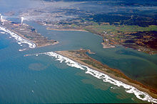
Humboldt Bay is a natural bay and a multi-basin, bar-built coastal lagoon located on the rugged North Coast of California, entirely within Humboldt County, United States. It is the largest protected body of water on the West Coast between San Francisco Bay and Puget Sound, the second-largest enclosed bay in California, and the largest port between San Francisco and Coos Bay, Oregon. The largest city adjoining the bay is Eureka, the regional center and county seat of Humboldt County, followed by the city of Arcata. These primary cities, together with adjoining unincorporated communities and several small towns, comprise a Humboldt Bay Area with a total population of nearly 80,000 people. This comprises nearly 60% of the population of Humboldt County. The bay is home to more than 100 plant species, 300 invertebrate species, 100 fish species, and 200 bird species. In addition, the bay and its complex system of marshes and grasses support hundreds of thousands of migrating and local shore birds. Commercially, this second-largest estuary in California is the site of the largest oyster production operations on the West Coast, producing more than half of all oysters farmed in California.
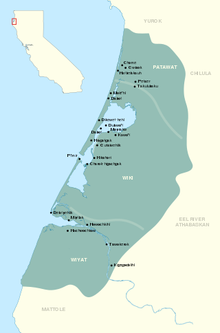
The Wiyot are an indigenous people of California living near Humboldt Bay, California and a small surrounding area. They are culturally similar to the Yurok people. They called themselves simply Ku'wil, meaning "the People". Today, there are approximately 450 Wiyot people. They are enrolled in several federally recognized tribes, such as the Wiyot Tribe, Bear River Band of the Rohnerville Rancheria, Blue Lake Rancheria, and the Cher-Ae Heights Indian Community of the Trinidad Rancheria.
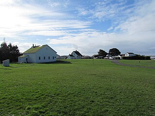
Fort Humboldt State Historic Park is a California state park, located in Eureka, California, United States. Its displays interpret the former U.S. Army fort, which was staffed from 1853–1870, the interactions between European Americans and Native Americans in roughly the same period, logging equipment and local narrow gauge railroad history of the region. Within the collection, there are trains, logging equipment, including a fully functional Steam Donkey engine, and an authentic Native American dug-out canoe. The Fort overlooks Humboldt Bay from a commanding position atop a bluff. The North Coast regional headquarters of the California State Parks system is located onsite.

Bayside is an unincorporated community 2.25 miles (3.6 km) south-southeast of Arcata, at an elevation of 33 feet in Humboldt County, California. The ZIP Code is 95524, the area code is 707. The relatively large area was originally covered by large, ancient Coast Redwood trees down to what was the edge of a significantly larger Humboldt Bay at high tide. Later, the mammoth redwoods made it the natural placement of some of the area's earliest redwood lumber operations. A rock quarry was located in the area's hills, which form the beginning of the Coast Ranges, the source of water for an early public water system for the City of Arcata. Today, Bayside provides Arcata a buffer from Eureka's northward expansion along US Route 101 and the area, with the exception of some business and public buildings, is largely rural, with homes and small ranches dotting the landscape. Second growth forests exist mostly apart from cleared lands, which show some evidence of the extensive redwood forest that once existed in the form of large stumps. Some of the area's older Victorian era houses, are still present on the Old Arcata Road, the original main road connecting Arcata to Eureka. Jacoby Creek runs alongside a road of the same name from the hills in the direction of the Bay.

The Mad River is a river in upper Northern California. It flows for 113 miles (182 km) in a roughly northwest direction through Trinity County and then Humboldt County, draining a 497-square-mile (1,290 km2) watershed into the Pacific Ocean north of the town of Arcata near [California Redwood Coast-Humboldt County Airport] in McKinleyville. The river's headwaters are in the Coast Range near South Kelsey Ridge.

Loleta is a census-designated place in Humboldt County, California. Loleta is located 5.5 miles (9 km) south of Fields Landing, and 15 miles (24 km) south of Eureka at an elevation of 46 feet (14 m). The population was 783 at the 2010 census. Residents live in a central community area and rural outskirts. There are two separate Native American reservations on the rural outskirts of Table Bluff, California.
The Sequoia Park Zoo is a zoo located in Eureka, California, operated by the City of Eureka. The zoo is part of a larger park complex including 60-acre (24 ha) of mature second-growth coast redwood forest, Eureka's largest public playground, and a duck pond, in addition to formal and natural gardens. The gardens include many varieties of rhododendron. The zoo's mission is "to inspire wonder, understanding and respect for the natural world by providing fun, rewarding, educational experiences that encourage meaningful connections between animals, humans, and our environment". The zoo is open to the public daily, except in winter when it is closed on Mondays. The zoo houses about 200 vertebrates and hundreds of invertebrates, representing about 54 different species on 7-acre (2.8 ha).

Table Bluff is a semi-flat terrace in Humboldt County, California, that terminates above the ocean in a dramatic, 165-foot (50 m) high cliff with views of the Eel River delta, the South Spit of Humboldt Bay, and the Pacific Ocean. It separates Humboldt Bay to the north from the Eel River to the south. It overlooks approximately 9,000 acres (36 km²) of wildlands administered by various federal and county agencies. It is 12 miles (19 km) south of Eureka and 5.5 miles (8.9 km) west of US Highway 101. Table Bluff County Park provides access to the South Spit. The park is also used as a hang-gliding and paragliding staging area. The federally endangered western lily, Lilium occidentale, is found growing on Table Bluff at Table Bluff Ecological Reserve.
The Clarke Historical Museum in Eureka, California contains the area's premier collection of California North Coast regional and cultural history. The facility has an entire Native American wing, Nealis Hall, which features an extensive internationally recognized collection of basketry, regalia, stoneware, implements, and other objects indicative of the culture and creativity of local and regional Native American groups including the Wiyot, Yurok, Karuk and Hupa Tribes. The Eureka Visitors Center is located in the main hall of the museum. The Clarke Museum is a 501 (c)3 non-profit.
The Wiyot massacre refers to the incidents on February 26, 1860, at Tuluwat, near Eureka in Humboldt County, California. In coordinated attacks beginning at about 6 am, White settlers murdered 80 to 250 Wiyot people with axes, knives, and guns. The February 26 attacks were followed by similar bloody attacks on other Wiyot villages later that week.

Seth Kinman was an early settler of Humboldt County, California, a hunter based in Fort Humboldt, a famous chair maker, and a nationally recognized entertainer. He stood over 6 ft (1.83 m) tall and was known for his hunting prowess and his brutality toward bears and Indian warriors. Kinman claimed to have shot a total of over 800 grizzly bears, and, in a single month, over 50 elk. He was also a hotel keeper, saloon keeper, and a musician who performed for President Lincoln on a fiddle made from the skull of a mule.

Fields Landing is a census-designated place in Humboldt County, California. It is located on Humboldt Bay 6 miles (9.7 km) south-southwest of downtown Eureka, at an elevation of 13 feet. The ZIP Code is 95537. The population was 276 at the 2010 census.
Kneeland is an unincorporated community in Humboldt County, California. It is located 7.5 miles (12 km) south-southwest of Korbel, at an elevation of 2,129 feet (649 m). Kneeland Airport is nearby. The ZIP code is 95549.

Bald Hills War (1858–1864) was a war fought by the forces of the California Militia, California Volunteers and soldiers of the U.S. Army against the Chilula, Lassik, Hupa, Mattole, Nongatl, Sinkyone, Tsnungwe, Wailaki, Whilkut and Wiyot Native American peoples.
Henry P. Larrabee, also known as Hank Larrabee, was a 49er and a rancher in the Eel River Valley of Humboldt County, California. In this region, he was notorious for his treatment of the native Indian people. Subsequently, he was a sheriff in Montana, a family man, businessman and school board member in Kansas.
The Wiyot Tribe is a federally recognized tribe of Wiyot people. They are the aboriginal people of Humboldt Bay, Mad River and lower Eel River.

Land Back is a decentralised campaign by Native Americans in the United States and Indigenous peoples in Canada that seeks to reestablish Indigenous sovereignty, with political and economic control of their unceded traditional lands. Activists have also used the Land Back framework in Mexico, and scholars have applied it in New Zealand and Fiji.