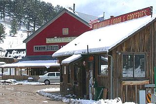
Rollinsville is a census-designated place and a U.S. Post Office located in Gilpin County, Colorado, United States. It is located in the mountains southwest of the city of Boulder, on the flank of a hill above South Boulder Creek along State Highway 119 between Nederland and Black Hawk. It consists of a small cluster of residences and several businesses at the terminus of the road leading westward up to Rollins Pass at the summit of the Front Range. The population as of the 2010 Census was 181. The Rollinsville post office has the ZIP Code 80474.

Watkins is a census-designated place (CDP) in Arapahoe and Adams counties, Colorado, United States, adjacent to the city of Aurora. It was formerly an incorporated town. The post office serving Watkins, which actually lies within the Aurora city limits, has the ZIP Code 80137. As of the 2010 census Watkins had a population of 653.

Dupont is an unincorporated community and U.S. Post Office in Adams County, Colorado, United States. The Dupont Post Office has the ZIP Code 80024.

Hygiene is an unincorporated community with a U.S. Post Office in Boulder County, Colorado, United States. Application for the first Hygiene Post Office was made by Rev. Jacob Stoner Flory of the United Church of the Brethren on May 28, 1883 ZIP Code 80533. This community's name stems from a time when it had a sanitarium to work with tuberculosis patients.

Joes is a census-designated place and a U.S. Post Office in Yuma County, Colorado, United States. The population as of the 2010 Census was 80. The Joes Post Office has the ZIP Code 80822.
Segundo is an unincorporated community and census-designated place in Las Animas County, Colorado, United States. Its population was 98 at the 2010 census. It is located 14 miles (23 km) west of Trinidad along Colorado State Highway 12 in the valley of the Purgatoire River.

Valmont is a census-designated place (CDP) in Boulder County, Colorado, United States. The population as of the 2010 Census was 59.
Cameo is an extinct town in Mesa County, in the U.S. state of Colorado. The GNIS classifies it as a populated place.
Axial is an extinct town in Moffat County, in the U.S. state of Colorado. The GNIS classifies it as a populated place.
Beshoar is an extinct town in Las Animas County, in the U.S. state of Colorado. The GNIS classifies it as a populated place.
Bloom is an extinct town in Otero County, in the U.S. state of Colorado. The GNIS classifies it as a populated place.
Bowen is an extinct town in Las Animas County, in the U.S. state of Colorado. The precise location of the town site is unknown to the GNIS.
Canfield is an unincorporated community in Boulder County, in the U.S. state of Colorado.
Cornish is an unincorporated community in Weld County, in the U.S. state of Colorado.
Elkton is an extinct town in Teller County, Colorado, United States. The GNIS classifies it as a populated place.
Iola is an extinct town in Gunnison County, in the U.S. state of Colorado. The community was inundated and destroyed by the creation of Blue Mesa Reservoir.
Kokomo is a silver- and gold-mining ghost town in Summit County, in the U.S. state of Colorado. Before being depopulated in the 1960s, Kokomo was at its height home to over 10,000 people.
Masters is an extinct town in Weld County, in the U.S. state of Colorado. The GNIS classifies it as a populated place.

Tercio is an extinct town in Las Animas County, in the U.S. state of Colorado. The GNIS classifies it as a populated place.
Tiger is an extinct town in Summit County, in the U.S. state of Colorado.

