
Polk County is a county located in the U.S. state of Arkansas. As of the 2020 census, the population was 19,221. The county seat is Mena. Polk County is Arkansas's 48th county, formed on November 30, 1844; it was named for James K. Polk, 11th President of the United States.

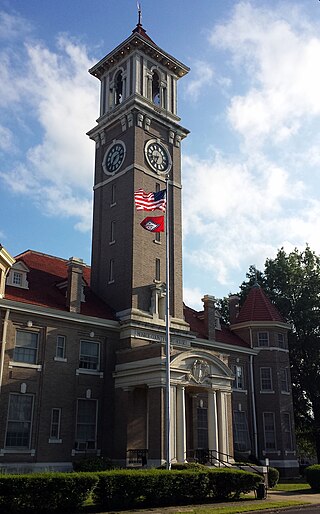
Phillips County is a county located in the eastern part of the U.S. state of Arkansas, in what is known as the Arkansas Delta along the Mississippi River. As of the 2020 census, the population was 16,568. The county seat is Helena–West Helena.
Monroe County is located in the Arkansas Delta in the U.S. state of Arkansas. The county is named for James Monroe, the fifth President of the United States. Created as Arkansas's 20th county on November 2, 1829, Monroe County is home to two incorporated towns and three incorporated cities, including Clarendon, the county seat, and Brinkley, the most populous city. The county is also the site of numerous unincorporated communities and ghost towns.
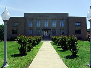
Lincoln County is located between the Arkansas Timberlands and Arkansas Delta in the U.S. state of Arkansas. It is also within the Pine Bluff metro area, and on the outer edge of the Central Arkansas region. The county is named for President Abraham Lincoln. Created as Arkansas's 65th county on March 28, 1871, Lincoln County has three incorporated cities, including Star City, the county seat and most populous city. The county contains 46 unincorporated communities and ghost towns, Cane Creek State Park at the confluence of Cane Creek and Bayou Bartholomew, and nine listings on the National Register of Historic Places to preserve the history and culture of the county.

Cross County is a rural Northeast Arkansas county in the Arkansas Delta. Created as Arkansas's 53rd county on November 15, 1862, Cross County contains four incorporated municipalities, including Wynne, the county seat and most populous city. It is named for Confederate Colonel David C. Cross, a political leader in the area.

Baxter County is a county in the U.S. state of Arkansas. As of the 2020 census, the county's population was 41,627. The county seat is Mountain Home. It is Arkansas's 66th county, formed on March 24, 1873, and named for Elisha Baxter, the tenth governor of Arkansas.

Ashley County is a rural South Arkansas county with a culture, economy, and history based on timber and agriculture. Created as Arkansas's 52nd county on November 30, 1848, Ashley County has seven incorporated municipalities, including Hamburg, the county seat and Crossett, the most populous city. The county is also the site of numerous unincorporated communities and ghost towns. The county is named for Chester Ashley, a prominent lawyer in the Arkansas Territory and U.S. senator from the state from 1844 to 1848.


Crowley's Ridge Parkway is a 212.0-mile-long (341.2 km) National Scenic Byway in northeast Arkansas and the Missouri Bootheel along Crowley's Ridge in the United States. Motorists can access the parkway from US Route 49 (US 49) at its southern terminus near the Helena Bridge over the Mississippi River outside Helena-West Helena, Arkansas, or from Missouri Route 25 (Route 25) near Kennett, Missouri. The parkway runs along Crowley's Ridge, a unique geological formation, and also parts of the St. Francis National Forest, the Mississippi River and the Mississippi Alluvial Plain. Along the route are many National Register of Historic Places properties, Civil War battlefields, parks, and other archeological and culturally significant points.
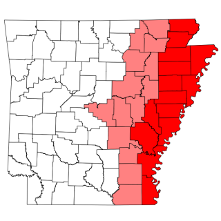
The Arkansas Delta is one of the six natural regions of the state of Arkansas. Willard B. Gatewood Jr., author of The Arkansas Delta: Land of Paradox, says that rich cotton lands of the Arkansas Delta make that area "The Deepest of the Deep South."

Highway 1 is a north–south state highway in east Arkansas. The route of 159.88 miles (257.30 km) runs from US Route 278 (US 278) in McGehee north to Supplemental Route BB at the Missouri state line. One of the original 1926 state highways, Highway 1 has remained very close to its original routing. The highway contains an overlap of approximately 50 miles (80 km) with U.S. Route 49.

Arkansas Highway 242 is an east–west state highway in Phillips County, Arkansas. The route of 14.74 miles (23.72 km) runs from Highway 44 near Helena-West Helena north through the city and through the St. Francis National Forest to Highway 1 near Lexa. A segment of the route is part of the Mississippi River Trail, essentially a bicycle-friendly version of the Great River Road.

Several special routes of U.S. Route 49 exist. In order from south to north they are as follows.

Arkansas Highway 20 is an east–west state highway in Phillips County, Arkansas. The route of 31.76 miles (51.11 km) runs from Lambrook northeast to US 49 in Helena-West Helena. Segments of the route make up the western routing of the Great River Road.

Highway 39 is a designation for two state highways in southeast Arkansas. The western segment of 9.98 miles (16.06 km) runs from US Route 49 (US 49) at Blackton to US 49/Highway 241. Another segment of 8.89 miles (14.31 km) runs north from Highway 1 and Highway 316 near Turner to US 49 in rural Phillips County.

The Tichnor Rice Dryer and Storage Building is a historic rice processing facility at 1030 Arkansas Highway 44 in Tichnor, Arkansas. It is an L-shaped structure, four stories in height, and rests on a concrete pad that is open to truck access on its north, east, southeast, and northwest elevations. It is sided in corrugated metal and has a metal gable roof. Built in 1955-56 for Woodrow Turner, it is the largest building in the small community, and remains an important facility for local rice growers to dry their crop.

The Richardson-Turner House is a historic house at 1469 Arkansas Highway 1 in Lexa, Arkansas. It is a 1+1⁄2-story wood-frame structure, built in 1894 by Dr. Willis Moss Richardson. It is one of the most elaborate rural Queen Anne structures in Phillips County, with asymmetric massing, decorative brackets in the eaves, fish-scale shingles on the exterior, and an elaborate porch with a beaded spindlework balustrade and turned columns. The house originally had a tower, but this was removed in the 1930s, and the attic space was enlarged for living space in the 1940s.

The Turner Historic District encompasses the 19th-century core of the small community of Cypert in rural Phillips County, Arkansas. Located at the junction of Arkansas Highway 318 and County Road 606, south-southwest of Marvell, the district includes a store and house, both built and operated by members of the Turner family, who were among the first to settle the area. The John L. Turner House, built in 1896, is unusual as a relatively high-style Queen Anne Victorian for such a remote rural area. The N. B. Turner & Son Store, built in 1892, is wood-frame structure with Folk Victorian styling. Both properties continue to be owned by members of the Turner family.
Cypert is an unincorporated community in Phillips County, Arkansas, United States. The community is located on Arkansas Highway 318, 5.2 miles (8.4 km) south-southwest of Marvell.

Highway 318 is a designation for two state highways in Phillips County, Arkansas. One route of 4.39 miles (7.07 km) begins at Highway 85 at Oneida and runs east to Highway 44. A second route of 15.12 miles (24.33 km) begins at Highway 1 and runs east to Highway 20. A portion of the route between Watkins Corner and Lambrook is designated as part of the Great River Road National Scenic Byway.

