
Wheatland County is a county in the U.S. state of Montana. As of the 2020 census, the population was 2,069. Its county seat is Harlowton. Wheatland County was established on February 22, 1917, with areas partitioned from Meagher and Sweet Grass counties. It was named for the abundant wheat-growing areas across the center portion of the new county's area.

Murray County is a county located in the northwestern part of the U.S. state of Georgia. As of the 2020 census, the population was 39,973. The county seat is Chatsworth.

Harlowton is a city in and the county seat of Wheatland County, Montana, United States. The population was 955 at the 2020 census.

Huntley is a census-designated place (CDP) in Yellowstone County, Montana, United States. The population was 411 at the 2000 census. Huntley lent its name to the Huntley Project, a federal irrigation project that began delivering water to the arid district in 1907. Today, Huntley is an eastern suburb of Billings and is located east of Shepherd and west of Worden.

Springfield is an unincorporated community and census-designated place in the town of Lyons, in Walworth County, Wisconsin, United States. As of the 2020 census, its population was 168. Located just northeast of Lake Geneva, it contains a mere eight streets. Springfield has an area of 0.673 square miles (1.74 km2), all of it land.

Stockwell, originally named Lauramie, is a census-designated place in Lauramie Township, Tippecanoe County, in the U.S. state of Indiana. It was once a stop along the Indianapolis, Cincinnati and Lafayette Railroad, but the rail line has since been removed.
Pompeys Pillar is a Census Designated Place in Yellowstone County, Montana, United States and has a postal ZIP code (59064).
Collins is an unincorporated census-designated place in the town of Rockland, Manitowoc County, Wisconsin, United States, in the east central part of the state. Its zip code is 54207, although its post office is being studied for closure. As of the 2010 census, its population is 164. The Collins Marsh Wildlife Area is located east of the community. Wisconsin Highway 32 ran through the community; the route later became Wisconsin Highway 67 before it became County Highway W. County Highway JJ and the Wisconsin Central Ltd. railroad runs east–west through the community. Collins has an area of 0.496 square miles (1.28 km2), all of it land. The community was named for Sumner J. Collins, who was the general superintendent of the Wisconsin Central Railroad in the 1890s.
Trego is an unincorporated community, and census-designated place (CDP), in Lincoln County, Montana, United States. As of the 2010 census it had a population of 541. Trego is located 1.5 miles west of Highway 93 and serves as the gateway community to the Tobacco Valley.
Hilger is an unincorporated community and census-designated place in Fergus County, Montana, United States. The community is located along U.S. Highway 191 in central Fergus County. Hilger has a post office with the ZIP code 59451. It is 15 miles north of Lewistown.

Huson is a census-designated place and unincorporated community in Missoula County, Montana, United States. Its population was 210 as of the 2010 census. The community is located along Interstate 90 19 miles (31 km) northwest of Missoula.
Pray is a census-designated place and unincorporated community in Park County, Montana, United States, in the Paradise Valley. The town was founded in 1907 by Valentine Eggar, an entrepreneur. He named it after Congressman Charles Nelson Pray. Its population was 681 as of the 2010 census. Pray has a post office with ZIP code 59065, which opened on December 8, 1909.
Shawmut is a census-designated place and unincorporated community in Wheatland County, Montana, United States. Its population was 42 as of the 2010 census. Shawmut has a post office with ZIP code 59078, which opened on October 27, 1885. The community is located along U.S. Route 12 and Montana Highway 3.
Dupuyer is a census-designated place and unincorporated community in Pondera County, Montana, United States. Its population was 86 as of the 2010 census. The community is located along U.S. Route 89 and Dupuyer Creek. Dupuyer has a post office with ZIP code 59432.
Sand Coulee is a census-designated place and unincorporated community in Cascade County, Montana, United States. Its population was 212 as of the 2010 census. Sand Coulee has a post office with ZIP code 59472.
Stockett is a census-designated place and unincorporated community in Cascade County, Montana, United States. Its population was 169 as of the 2010 census. Stockett has a post office with ZIP code 59480.
Marion is a census-designated place and unincorporated community in Flathead County, Montana, United States. Its population was 1,119 as of the 2020 census. Marion has a post office with ZIP code 59925.
Frisbee is an unincorporated community and Census-designated place in Dunklin County, in the U.S. state of Missouri.
Duncan Ranch Colony is a Hutterite community and census-designated place (CDP) in Wheatland County, Montana, United States. It is in the west-central part of the county, on the south side of U.S. Route 12, 9 miles (14 km) west of Harlowton, the county seat, and 3 miles (5 km) east of Twodot. The Musselshell River flows eastward through the colony.
Harlowton Public Schools is a school district headquartered in Harlowton, Montana. It operates two schools: Hillcrest Elementary School and Harlowton High School.
 Two Dot State Bank, Aug 1977
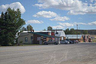
 TwoDot Bar, 2011
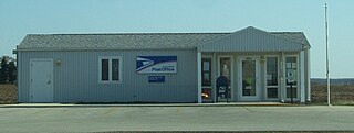
 Two Dot post office, 2022
 Two Dot postal cancellation


