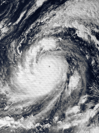
Typhoon Tip, known in the Philippines as Super Typhoon Warling, was the largest and most intense tropical cyclone ever recorded. The forty-third tropical depression, nineteenth tropical storm, twelfth typhoon, and third super typhoon of the 1979 Pacific typhoon season, Tip developed out of a disturbance within the monsoon trough on October 4 near Pohnpei in Micronesia. Initially, Tropical Storm Roger to the northwest hindered the development and motion of Tip, though after the storm tracked farther north, Tip was able to intensify. After passing Guam, Tip rapidly intensified and reached peak sustained winds of 305 km/h (190 mph) and a worldwide record-low sea-level pressure of 870 hPa (25.69 inHg) on October 12. At its peak intensity, Tip was the largest tropical cyclone on record, with a wind diameter of 2,220 km (1,380 mi). Tip slowly weakened as it continued west-northwestward and later turned to the northeast, in response to an approaching trough. The typhoon made landfall in southern Japan on October 19, and became an extratropical cyclone shortly thereafter. Tip's extratropical remnants continued moving east-northeastward, until they dissipated near the Aleutian Islands on October 24.

The 1992 Pacific typhoon season is the fourth consecutive above-average season, producing 31 tropical storms, 16 typhoons and five super typhoons. It had no official bounds; it ran year-round in 1992. Despite this, most tropical cyclones tend to form in the northwestern Pacific Ocean between May and November. These dates conventionally delimit the period of each year when most tropical cyclones form in the northwestern Pacific Ocean.

The 1989 Pacific typhoon season was the first of six consecutive years of above-average activity in the Western Pacific. It was an extremely active season spawning 32 tropical storms, 20 typhoons and five super typhoons. It has no official bounds; it ran year-round in 1989, but most tropical cyclones tend to form in the northwestern Pacific Ocean between May and November. These dates conventionally delimit the period of each year when most tropical cyclones form in the northwestern Pacific Ocean. The first storm, Winona, formed on January 15, while the final storm, Jack, dissipated on December 27. This season was also quite a deadly season that were caused by a few notable storms such as Tropical Storm Cecil, which was the worst storm to impact Vietnam in over 50 years, and Typhoon Gay, which directly impacted the Malay Peninsula as the worst typhoon in 35 years. Both of these storms make up around half of the total fatalities of the entire season alone.

The 1971 Pacific typhoon season was an extremely active season that featured the second highest typhoon count on record. It has no official bounds; it ran year-round in 1971, but most tropical cyclones tend to form in the northwestern Pacific Ocean between June and December. These dates conventionally delimit the period of each year when most tropical cyclones form in the northwestern Pacific Ocean.

The 1962 Pacific typhoon season had no official bounds; there was activity in every month but January, March, and June, but most tropical cyclones form in the northwestern Pacific Ocean between May and November and this conventionally delimits the season.

The 1960 Pacific typhoon season had no official bounds; it ran year-round in 1960, but most tropical cyclones tend to form in the northwestern Pacific Ocean between June and December. These dates conventionally delimit the period of each year when most tropical cyclones form in the northwestern Pacific Ocean.
The 1958 Pacific typhoon season was an event in the annual cycle of tropical cyclone formation. The season had no official bounds, but tropical cyclones in the Western Pacific Ocean normally develop between May and October. The season was below average in storms, with only twenty-three forming. However, all but two of those storms developed into typhoons, resulting in a well above-average number of typhoons, and a very high ACE figure of 445.8 units. In addition, there were also nine tropical storms tracked only by the JMA. The season began very early, with a very rare super typhoon in January, Typhoon Ophelia, and ended in early December with Typhoon Olga. It also featured Typhoon Ida, the strongest storm ever recorded at that time.

The 1957 Pacific typhoon season has no official bounds; it ran year-round in 1957, but most tropical cyclones tend to form in the northwestern Pacific Ocean between June and December. These dates conventionally delimit the period of each year when most tropical cyclones form in the northwestern Pacific Ocean.

The 1956 Pacific typhoon season has no official bounds; it ran year-round in 1956, but most tropical cyclones tend to form in the northwestern Pacific Ocean between June and December. These dates conventionally delimit the period of each year when most tropical cyclones form in the northwestern Pacific Ocean.

The 1951 Pacific typhoon season was a generally average season with multiple tropical cyclones striking the Philippines. With the exception of January, each month saw at least one tropical system develop; October was the most active month with four tropical cyclones forming. Overall, there were 31 tropical depressions, of which 25 became tropical storms; of those, there were 16 typhoons.

Typhoon Rose, known in the Philippines as Typhoon Uring, was the most violent and intense tropical cyclone to strike Hong Kong since Typhoon Wanda in 1962. The 21st named storm of the 1971 Pacific typhoon season, Rose developed from an area of disturbed weather while west of Guam on August 9. Moving west-northwestward, the storm briefly became a typhoon on the following day. After weakening to a tropical storm on August 11, Rose re-intensified into a typhoon several hours later. The system then curved westward and reached a primary peak intensity with winds of 205 km/h (127 mph) on August 13. Later that day, the typhoon made landfall near Palanan, Isabela in the Philippines. Rose weakened significantly while crossing the island of Luzon and was a minimal typhoon upon reaching the South China Sea on August 14.
Typhoon Saomai, known in the Philippines as Super Typhoon Juan, was considered the most powerful typhoon on record to strike the east coast of the People's Republic of China. It was the eighth tropical storm, fifth typhoon, and third super typhoon of the 2006 Pacific typhoon season recognized by the Joint Typhoon Warning Center. According to the Japan Meteorological Agency, Saomai was the seventh tropical storm and fifth typhoon of the season. The name "Saomai" was submitted by Vietnam, and is from the Vietnamese word for "morning star", a reference to the planet Venus.

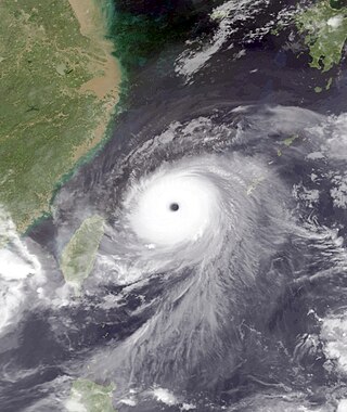
Typhoon Wanda was one of the most intense tropical cyclones on record in Hong Kong. It was the 59th disturbance in the record-breaking 1962 Pacific typhoon season, forming in August east of the Philippines. Typhoon Wanda reached peak winds of 175 km/h (110 mph) in the South China Sea, and it made landfall on Hong Kong on September 1, producing gusts of 261 km/h (161 mph) which, in combination with a high storm surge, damaged thousands of huts and left 72,000 people homeless. Wanda left a total of 434 deaths, and it is estimated that an identical typhoon striking today would cause HK$2.6 billion in losses.
The 1939 Pacific typhoon season has no official bounds; it ran year-round in 1939, but most tropical cyclones tend to form in the northwestern Pacific Ocean between May and November. These dates conventionally delimit the period of each year when most tropical cyclones form in the northwestern Pacific Ocean.

Typhoon Alex, known in the Philippines as Typhoon Etang, affected the Taiwan, China, and South Korea during July 1987. Typhoon Alex developed from the monsoon trough that spawned a tropical disturbance late on July 21 southwest of Guam which organized into a tropical depression shortly thereafter. The system steadily became better organized, and the next day, a tropical depression had developed. Satellite intensity estimates gradually increased, and on July 23, the depression intensified into Tropical Storm Alex. After initially tracking west-northwest, Tropical Storm Alex started tracking northwest. An eye developed on July 24, and on the next day, Alex was classified as a typhoon, when Alex attained its peak intensity of 120 km/h (75 mph) and a minimum barometric pressure of 970 mbar (29 inHg). Alex weakened while tracking more northward, though interaction with Taiwan resulted in a more westward track starting on July 27. The storm struck near Shanghai as a tropical storm, and weakened over land, although it remained identifiable through August 2.
The 1940 Pacific typhoon season marked an interruption in meteorological records in both the Philippines and Hong Kong due to the start of World War II. There were 43 reported tropical cyclones, including 27 that attained typhoon status. The first storm was observed in February, and the first typhoon formed two months later, killing three people along Mindanao. Several storms formed in June and July, including reports of a typhoon in the newspapers that killed 52 in South Korea, and another typhoon reported in newspapers that killed one person on Samar after dropping heavy rainfall. The strongest typhoon of the season originated in July and attained a minimum pressure of 927 mbar (27.4 inHg), as reported by a ship northeast of the Philippines.

Typhoon Khanun, known in the Philippines as Typhoon Kiko, was the strongest tropical cyclone to make landfall on Zhejiang Province since Wanda in 1956. Khanun developed from an area of convection east-southeast of Yap on September 5, thereafter tracking northwestward. The precursor reached tropical storm status on September 7 and typhoon intensity the next day. The tropical cyclone reached its peak intensity on September 10 with winds estimated at 155 km/h (100 mph) and a minimum barometric pressure of 945 mbar. After weakening slightly, Khanun moved ashore Zhejiang Province the next day, weakening further as it tracked over land. After recurving into the Yellow Sea on September 12, Khanun became extratropical; these remnants continued to track into the open North Pacific before they were last noted on September 16.

Typhoon Meranti, known in the Philippines as Super Typhoon Ferdie, was one of the most intense tropical cyclones on record. Impacting the Batanes in the Philippines, Taiwan, as well as Fujian Province in September 2016, Meranti formed as a tropical depression on September 8 near the island of Guam. Tracking to the west northwest, Meranti gradually intensified until September 11, at which point it began a period of rapid intensification. Continuing to rapidly intensify, it became a super typhoon early on September 12, as it passed through the Luzon Strait, ultimately reaching its peak intensity on September 13 with 1-minute sustained winds of 315 km/h (195 mph). Shortly afterwards, it passed directly over the island of Itbayat. Meranti passed to the south of Taiwan as a super typhoon, and began weakening steadily as a result of land interaction. By September 15, it struck Fujian Province as a Category 2-equivalent typhoon, becoming the strongest typhoon on record to impact the province. Upon moving inland, rapid weakening ensued and Meranti became extratropical the next day, dissipating shortly afterwards after it passed to the south of the Korean Peninsula.
There were 30 tropical cyclones in the western Pacific Ocean in 1931, including 19 typhoons, as well as one that developed in December of the previous year. The most significant typhoon was one that struck eastern China near Shanghai in the midst of the country's worst floods on record; heavy rainfall caused levees to collapse along the Grand Canal, killing an estimated 300,000 people, including about 2,000 people overnight in the city of Gaoyou.
In 1936, there were 33 tropical cyclones across the northwestern Pacific Ocean, north of the equator and west of the International Date Line, including two that persisted from the previous year. There were at least 19 typhoons, which are tropical cyclones with sustained winds of at least 119 kilometres per hour (74 mph). The year's strongest observed typhoon was in August, when the Fathomer rode out the storm in along the northern Philippines island of Luzon, observing a barometric pressure of 913 mbar (26.96 inHg). The typhoon killed 20 people, one of several deadly tropical cyclones in the year. Also in August, a typhoon crossed the Korean peninsula, killing 1,516 people, with another 1,183 people injured. In October, another typhoon moved across Luzon, killing 546 people.


