A tornado struck Phoenix while she rode at anchor in Mississippi Sound on the U.S. Gulf Coast on the night of 31 March 1854, causing her to capsize and sink in 20 seconds. Her crew survived by clinging to her mastheads, which remained above water after she sank in 20 feet (6.1 meters) of water. The crew managed to free one of her boats about an hour after she sank and row to shore safely. She was raised three weeks later, repaired, and returned to service. Her captain, Coast Survey Assistant Julius E. Hilgard, took advantage of the calamity to examine and report on the condition of surveying instruments aboard Phoenix after their three-week immersion in seawater.[2]
Phoenix spent the 1855 field season transporting and housing Coast Survey teams who triangulated an approximately 60-mile (97-kilometer) stretch of coast between Pascagoula, Mississippi, and the entrance to Lake Pontchartrain in Louisiana. In 1856, she supported survey parties along the coast of Texas, arriving there with significant storm damage after a rough passage.[2]
The National Geodetic Survey (NGS), formerly the United States Survey of the Coast (1807–1836), United States Coast Survey (1836–1878), and United States Coast and Geodetic Survey (USC&GS) (1878–1970), is a United States federal agency that defines and manages a national coordinate system, providing the foundation for transportation and communication; mapping and charting; and a large number of applications of science and engineering. Since its foundation in its present form in 1970, it has been part of the National Oceanic and Atmospheric Administration (NOAA), of the United States Department of Commerce.
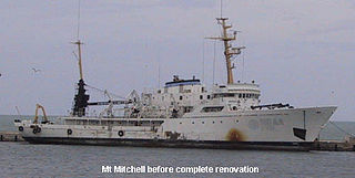
NOAAS Mount Mitchell was an American survey vessel in commission in the National Oceanic and Atmospheric Administration from 1970 to 1995. Prior to her NOAA career, she was in commission in the United States Coast and Geodetic Survey as USC&GS Mount Mitchell from 1968 to 1970. In 2003, she returned to service as the private research ship R/V Mt. Mitchell.
USS Surveyor was an armed steamer that served in the United States Navy from 1917 to 1919. Prior to her U.S. Navy service, she operated as the survey ship USC&GS Surveyor for the United States Coast and Geodetic Survey in 1917, and she returned to that role after her U.S. Navy decommissioning, remaining in Coast and Geodetic Survey service until 1956.
USC&GS Yukon was a steamer that served as a survey ship in the United States Coast and Geodetic Survey from 1898 to 1923. She was the second and last Coast and Geodetic Survey ship to bear the name.
USCS Belle was a schooner that served as a survey ship in the United States Coast Survey from 1848 to 1857.
USCS Robert J. Walker was a survey ship that served in the United States Coast Survey, a predecessor of the United States Coast and Geodetic Survey, from 1848 until sinking in 1860 after a collision at sea. Her loss resulted in the death of 20 men, the greatest loss of life in single incident ever to befall the National Oceanic and Atmospheric Administration or any of its ancestor agencies.
USC&GS Isis was a survey ship that served in the United States Coast and Geodetic Survey from 1915 to 1917 and from 1919 to 1920.
The first USC&GS Hydrographer was a survey launch that served in the United States Coast and Geodetic Survey from 1901 to 1917 and from 1919 to 1928.
USC&GS Marindin was a launch that served as a survey ship in the United States Coast and Geodetic Survey from 1919 to 1944. She was the only Coast and Geodetic Survey ship to bear the name.
The first USC&GS Discoverer was a survey ship that served in the United States Coast and Geodetic Survey from 1922 to 1941.
NOAAS Heck was a Rude-class hydrographic survey ship in the National Oceanic and Atmospheric Administration (NOAA) from 1970 to 1995. Prior to her NOAA service, she was in commission from 1967 to 1970 in the United States Coast and Geodetic Survey as USC&GS Heck.
The second USC&GS Fathomer was a steamer that served as a survey ship in the United States Coast and Geodetic Survey from 1905 to 1942.
The first USC&GS McArthur, originally USCS McArthur, was a steamer that served as a survey ship in the United States Coast Survey from 1876 to 1878 and in the United States Coast and Geodetic Survey from 1878 to 1915.
USCS Varina was a schooner that served as a survey ship in the United States Coast Survey, a predecessor of the United States Coast and Geodetic Survey, from 1854 to 1875.
The USCS Morris was a schooner that served as a survey ship in the United States Coast Survey from 1849 to 1855.
The first USC&GSS Pathfinder, also noted in some NOAA histories as "old Pathfinder", was a United States Coast and Geodetic Survey ship in service from 1899 to 1941, when she was beached in sinking condition on January 30, 1942, after 40 years service in the Philippines.
USC&GS A. D. Bache (1871–1900), the second steamer of the U.S. Coast and Geodetic Survey, was named for the former superintendent Alexander Dallas Bache and launched August 1871 at Wilmington, Delaware.
The second USC&GS Explorer was a survey ship that served in the United States Coast and Geodetic Survey from 1940 to 1968. She operated in the Pacific Ocean from 1940 to 1960, seeing service there during World War II, and in the Atlantic Ocean from 1960 to 1968.
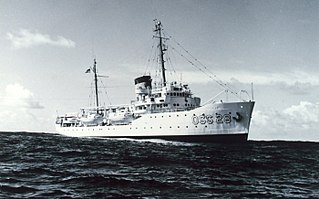
NOAAS Whiting, was an American survey ship that was in commission in the National Oceanic and Atmospheric Administration (NOAA) from 1970 to 2003. Previously, she had been in commission in the United States Coast and Geodetic Survey from 1963 to 1970 as USC&GS Whiting.
Captain Nicholas Hunter Heck was a career officer of the United States Coast and Geodetic Survey Corps. A leading geophysicist of his time, Heck made important contributions in the study of seismology and oceanography. He also revolutionized hydrographic surveying by developing the wire-drag surveying technique and introduced radio acoustic ranging into Coast and Geodetic Survey hydrography.
This page is based on this Wikipedia article Text is available under the CC BY-SA 4.0 license; additional terms may apply. Images, videos and audio are available under their respective licenses.