The Territory of Heard Island and McDonald Islands (HIMI) is an Australian external territory comprising a volcanic group of mostly barren Antarctic islands, about two-thirds of the way from Madagascar to Antarctica. The group's overall size is 372 km2 (144 sq mi) in area and it has 101.9 km (63 mi) of coastline. Discovered in the mid-19th century, the islands have been an Australian territory since 1947 and contain the country's two active volcanoes. The summit of one, Mawson Peak, is higher than any mountain on the Australian mainland. The islands lie on the Kerguelen Plateau in the Indian Ocean.

Rocky Islets are part of the Three Islands National Park in Far North Queensland, Australia, in the Coral Sea, 1605 km northwest of Brisbane.

Three Islands and Three Islands Reef are part of the Three Islands Group National Park in Far North Queensland, Australia, in the Coral Sea, 1,581 km (982 mi) northwest of Brisbane, about 44 km (27 mi) north-northeast of Cooktown.
Two Islands and Two Islands Reef are part of the Three Islands Group National Park in Far North Queensland, Australia, in the Coral Sea, 1,590 km (990 mi) northwest of Brisbane, about 50 km (31 mi) north-northeast of Cooktown, 10 km (6.2 mi) southeast of Cape Flattery, and 10 km (6.2 mi) north of Three Islands and Three Islands Reef.

Seabirds are birds that are adapted to life within the marine environment. While seabirds vary greatly in lifestyle, behaviour and physiology, they often exhibit striking convergent evolution, as the same environmental problems and feeding niches have resulted in similar adaptations. The first seabirds evolved in the Cretaceous period, and modern seabird families emerged in the Paleogene.

The Alaska Maritime National Wildlife Refuge is a United States National Wildlife Refuge comprising 2,400 islands, headlands, rocks, islets, spires and reefs in Alaska, with a total area of 4.9 million acres (20,000 km2), of which 2.64 million acres (10,700 km2) is wilderness. The refuge stretches from Cape Lisburne on the Chukchi Sea to the tip of the Aleutian Islands in the west and Forrester Island in the southern Alaska Panhandle region in the east. The refuge has diverse landforms and terrains, including tundra, rainforest, cliffs, volcanoes, beaches, lakes, and streams.

Algoa Bay is a bay in the Eastern Cape, South Africa. It is located in the east coast, 425 miles east of the Cape of Good Hope.

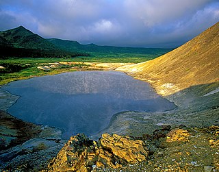
Chirinkotan is an uninhabited volcanic island located in the centre of the Kuril Islands chain in the Sea of Okhotsk in the northwest Pacific Ocean. Its name is derived from the Ainu language for "mudslide". It is located 3 kilometres west of Ekarma, its nearest neighbor.

Raikoke, also spelled Raykoke, is, as of 2019 an uninhabited volcanic island near the centre of the Kuril Islands chain in the Sea of Okhotsk in the northwest Pacific Ocean, 16 kilometres (9.9 mi) distant from the island of Matua. Its name is derived from the Ainu language, from “hellmouth”.
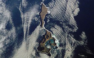
Ushishir is an uninhabited volcanic island located in the centre of the Kuril Islands chain in the Sea of Okhotsk in the northwest Pacific Ocean. Its name is derived from the Ainu language for "hot spring".
Gintautas Umaras is a retired track and road racing cyclist from Lithuania, who represented the USSR at the 1988 Summer Olympics in Seoul, South Korea. There he won the gold medal in the men's 4 km individual pursuit and in the men's team pursuit, alongside Viatcheslav Ekimov, Dmitry Nelyubin and Artūras Kasputis. During the Soviet time he trained at Dynamo sports society in Klaipėda.

Beryozovye Islands, alternatively spelled Berezovye Islands, is an island group in Leningrad Oblast, Russia. The islands are situated at the head of the Gulf of Finland, just outside the town of Primorsk on the Karelian Isthmus.

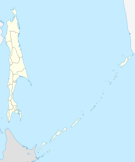
Tyuleny Island is a small island in the Sea of Okhotsk, east of Russia's Sakhalin Island, in Northeast Asia. It is also called Kaihyo Island (海豹島).

The Spafaryev Islands, or Spafaryev Island, a relatively large double island, are located in the Sea of Okhotsk. It was formerly known as Korovi Island. It lies 7 km east of the Antamlan Peninsula, the southernmost peninsula enclosing the Taui Bay from its western side.
Ush Island is an island in the northern coast of Sakhalin. Ush Island is located between a shallow bay and the Sea of Okhotsk, at the mouth of the Sakhalin Gulf.

The Yam Islands, Yamsky Islands or Yamskiye Islands, is a small island group located close to the coast in the northern Sea of Okhotsk. Administratively the Yam Islands belong to the Magadan Oblast of the Russian Federation.

The Nuggets is a close group of four granite islets, with a combined area of 6.76 hectares, in south-eastern Australia. They lie close to the eastern coast of Tasmania near the Freycinet Peninsula., and are near Cape Tourville, about 7 km north of Wineglass Bar and about 22 km north of Schouten Island.

Shelikan, also Ostrovok Shelikan, is a coastal islet in the Sea of Okhotsk near Magadan. It lies on the south side of Amakhton Bay.
Solander Island Ecological Reserve is a 7.7 ha protected area on an island 1.5 km (0.9 mi) west of Brooks Peninsula Provincial Park off the northwest coast of Vancouver Island in British Columbia, Canada. It was established in 1971. The reserve is closed to the public to protect the habitat of nesting seabirds.
Kurils Nature Reserve is a Russian 'zapovednik' covering the north and south portions of Kunashir Island, the largest and most southernmost of the Kuril Islands, which stretch between Hokkaido Island in Japan to the Kamchatka peninsula in the Russia Far East. It also covers two smaller islands nearby to the southeast. The area is one of the largest wintering sites for coastal seabirds. The reserve sits on a tectonically unstable location, and is one of two Russian national reserves that protects territory of active volcanoes. The reserve is situated in the Yuzhno-Kurilsky District of Sakhalin Oblast. The reserve was created in 1984, and covers an area of 65,364 ha (252.37 sq mi).