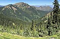
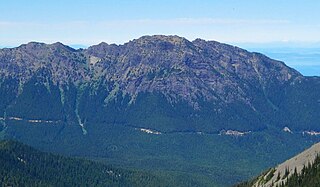
Mount Angeles is located just south of Port Angeles, Washington in the Olympic National Park. It is the highest peak in the Hurricane Ridge area. The summit, which offers panoramic views of the Strait of Juan de Fuca and many of the peaks of the interior Olympic Mountains can be climbed from the Klahane Ridge trail.
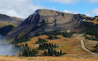
Obstruction Peak is a 6,450-foot-elevation (1,966-meter) summit in the Olympic Mountains and is located in Clallam County of Washington state. It is set within Olympic National Park and is situated at the eastern end of Obstruction Point Road which is a narrow eight-mile dirt road on Hurricane Ridge. The road ends below the south slope of Obstruction Peak, and a short hike leads to the summit. The nearest higher peak is Elk Mountain, 0.46 mi (0.74 km) to the northeast. Obstruction Peak is a major triple divide point such that precipitation runoff drains into tributaries of the Elwha River, Dungeness River, and Morse Creek. All three thence empty into the Strait of Juan de Fuca.

Eagle Point is a 6,247-foot-elevation (1,904-meter) summit in the Olympic Mountains and is located in Clallam County of Washington state. It is set on Hurricane Ridge within Olympic National Park. It is situated midway between Steeple Rock and Obstruction Peak, 1.42 mi (2.29 km) to the southeast. Precipitation runoff drains into tributaries of the Elwha River and Morse Creek, thence the Strait of Juan de Fuca.
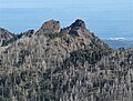
Steeple Rock is a 200-foot basalt pillar in the Olympic Mountains, and is located in Clallam County of Washington state. It rises next to the Obstruction Point Road on Hurricane Ridge within Olympic National Park. It's situated midway between Eagle Point and the Hurricane Ridge Visitor Center. Precipitation runoff drains into tributaries of the Elwha River and Morse Creek, thence to the Strait of Juan de Fuca.
Rocky Peak is a 6,218-foot-elevation (1,895-meter) mountain summit in the Olympic Mountains and is located in Clallam County of Washington state. It is situated eight miles south of Port Angeles, Washington, within Olympic National Park. The nearest higher neighbor is Mount Angeles, 1.87 mi (3.01 km) to the west. Klahhane Ridge connects these two peaks. Travelers on the scenic Hurricane Ridge Road traverse the lower south slope of Rocky Peak en route to the Hurricane Ridge visitor center. The mountain was named Rocky Peak by local people from the time of the earliest settlers in the area. Precipitation runoff from the north side of the peak drains into Rocky Creek, whereas the south slope drains into Morse Creek, thence into the Strait of Juan de Fuca.

Mount Meany is a prominent 6,695-foot (2,041-metre) mountain summit located deep within Olympic National Park in Jefferson County of Washington state. With a good eye and clear weather, the top of the mountain can be seen from the visitor center at Hurricane Ridge. The nearest neighbor is Mount Noyes less than one mile to the south, and the nearest higher peak is Circe (6,847 ft) on Mount Olympus, 4.07 mi (6.55 km) to the northwest. There are scrambling routes on the east side, via Noyes-Meany col, and via the ridge from Mount Queets. Due to heavy winter snowfalls, Mount Meany supports several small glaciers on its north and east slopes, despite its modest elevation. Precipitation runoff from the mountain drains into the headwaters of both the Elwha and Queets Rivers.

Elk Mountain is a 6,773-foot elevation (2,064 m) mountain summit located in the Olympic Mountains, in Clallam County of Washington state. It is set within Olympic National Park and is situated at the eastern end of Hurricane Ridge. The nearest higher peak is McCartney Peak, 5.12 mi (8.24 km) to the south-southwest. Precipitation runoff from the south slope of the mountain drains into tributaries of the Dungeness River, whereas the north slope is drained by tributaries of Morse Creek which thence empties into the Strait of Juan de Fuca.

Stephen Peak is a 6,418-foot (1,956-metre) mountain summit located within Olympic National Park in Jefferson County of Washington state. Stephen Peak is the fifth-highest peak in the Bailey Range, which is a subrange of the Olympic Mountains. In clear weather, the mountain can be seen from the visitor center at Hurricane Ridge, appearing to the left of Mount Olympus. Mount Ferry is set 2.26 mi (3.64 km) to the southeast, and Stephen's nearest higher neighbor is Ruth Peak which is an outlier of Mount Carrie, 2.1 mi (3.4 km) to the northwest. Precipitation runoff from the mountain drains into tributaries of the Elwha River and Hoh River. The first ascent of this peak was made in 1961 by Kent Heathershaw, Doug Waali, and Robert Wood.

Mount Fitzhenry is a 6,050-foot (1,840-metre) mountain summit located within Olympic National Park in Clallam County of Washington state. Mt. Fitzhenry is in the Bailey Range, which is a subrange of the Olympic Mountains. The mountain can be seen from the visitor center at Hurricane Ridge in clear weather. Its nearest higher neighbor is Mount Fairchild, 1.57 mi (2.53 km) to the south. Precipitation runoff from the mountain drains into tributaries of the Elwha River. Mount Fitzhenry is situated at the head of Fitzhenry Creek, and both are named for Edward Allen Fitzhenry (1868–1937), Clallam County surveyor from 1892-1900. President Woodrow Wilson appointed Fitzhenry as Washington Surveyor General in 1913, and he later served as Deputy State Land Commissioner.
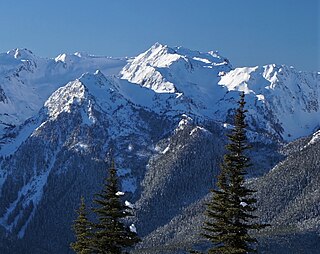
Mount Fairchild, also known as Mount William Fairchild, is a 6,900-foot (2,100-metre) glaciated mountain summit located within Olympic National Park in Clallam County of Washington state. Mt. Fairchild is the second-highest peak in the Bailey Range, which is a subrange of the Olympic Mountains. Its nearest higher neighbor is Mount Carrie, 0.84 mi (1.35 km) to the southwest, and Ruth Peak is set 0.92 mi (1.48 km) to the south. In clear weather, the mountain can be seen from the visitor center at Hurricane Ridge. Precipitation runoff from the mountain drains into tributaries of the Elwha River.

Mount Ferry is a 6,195-foot (1,888-metre) mountain summit located within Olympic National Park in Jefferson County of Washington state. Mount Ferry is the eighth-highest peak in the Bailey Range, which is a subrange of the Olympic Mountains. In clear weather, the mountain can be seen from the visitor center at Hurricane Ridge. Its nearest higher neighbor is Mount Pulitzer, 0.6 mi (0.97 km) to the southwest. Stephen Peak is set 2.26 mi (3.64 km) to the northwest, and Mount Olympus is 7.2 mi (11.6 km) to the southwest. Precipitation runoff from the mountain drains into tributaries of the Elwha and Hoh Rivers.
Mount Pulitzer, also known as Snagtooth, is a 6,283-foot (1,915-metre) mountain summit located within Olympic National Park in Jefferson County of Washington state. Mount Pulitzer is the sixth-highest peak in the Bailey Range, which is a subrange of the Olympic Mountains. Its nearest neighbor is Mount Ferry, 0.58 mi (0.93 km) to the northeast, and its nearest higher neighbor is Stephen Peak, 2.58 mi (4.15 km) to the north. Mount Olympus is set 6.8 mi (10.9 km) to the southwest. In clear weather, the mountain can be seen from the visitor center at Hurricane Ridge. Precipitation runoff from the mountain drains into tributaries of the Elwha and Hoh Rivers. The first ascent of the summit was made in 1961 by Doug Waali, Bob Wood, and Kent Heathershaw via the east ridge.

Ruth Peak is a 6,850+ ft glaciated mountain summit located within Olympic National Park in Clallam County of Washington state. Ruth Peak is the third-highest peak in the Bailey Range, which is a subrange of the Olympic Mountains. Its nearest higher neighbor is Mount Carrie, 0.91 mi (1.46 km) to the northwest, and Mount Fairchild is set 0.92 mi (1.48 km) to the north. In clear weather, the mountain can be seen from the visitor center at Hurricane Ridge. Precipitation runoff from the mountain drains into tributaries of the Hoh and Elwha Rivers. The first ascent of this peak was made in 1961 by Bert Brown, Roy Etten, and Victor Nelson.

Chimney Peak is a 6,917-foot-elevation (2,108-meter) mountain summit located within Olympic National Park in Jefferson County of Washington state. Chimney Peak is situated near the head of Elwha Valley, and immediately north above Enchanted Valley. Topographic relief is significant as the southeast aspect rises 4,800 feet above Enchanted Valley in less than one mile. Enchanted Valley is also known as Valley of 10,000 Waterfalls, and numerous waterfalls tumble down the immense cliffs of Chimney Peak. Neighbors include Crystal Peak, 2.2 mi (3.5 km) to the north, White Mountain 3.5 mi (5.6 km) to the east, and West Peak 3.4 mi (5.5 km) to the northeast. Precipitation runoff from the mountain drains north to the Elwha River, and south to the Quinault River.

Mount Wilder is a 5,939-foot (1,810-metre) mountain summit located near the head of the Elwha Valley, deep within Olympic National Park in Jefferson County of Washington state. Part of the Olympic Mountains, Wilder represents the southernmost peak of the Bailey Range. It is situated 8.7 miles east-southeast of Mount Olympus, and is set within the Daniel J. Evans Wilderness. Neighbors include line parent Mount Dana, 2.3 miles (3.7 km) to the northeast, and Mount Seattle rises 3.7 miles to the southwest. The headwaters of the Goldie River form on the south slope of the mountain, and precipitation runoff from the mountain drains into Goldie River and other tributaries of the Elwha River. Topographic relief is significant as the south aspect of the peak rises nearly 3,800 feet (1,160 m) in less than two miles.

Ludden Peak is a 5,854-foot (1,784-metre) mountain summit located within Olympic National Park in Jefferson County of Washington state. Ludden Peak is part of the Bailey Range, which is a subrange of the Olympic Mountains, and is set within the Daniel J. Evans Wilderness. In clear weather, the mountain can be seen from the park's visitor center on Hurricane Ridge. The nearest higher neighbor is Mount Scott, one mile to the south-southeast, line parent Mount Ferry rises 1.6 mi (2.6 km) to the southwest, Dodger Point is 1.9 mi (3.1 km) to the northeast, and Stephen Peak is set 2.7 mi (4.3 km) to the northwest. Precipitation runoff from the mountain drains into tributaries of the Elwha River.

Cat Peak is a 5,940-foot (1,811-metre) mountain summit within Olympic National Park in Clallam County of Washington state.

Dodger Point is a 5,760-foot (1,756-metre) mountain summit located within Olympic National Park in Jefferson County of Washington state.

Maiden Peak is a 6,434-foot (1,961 m) summit located in Olympic National Park, in Clallam County of Washington state. It is part of the Olympic Mountains and is situated near the eastern end of Hurricane Ridge within the Daniel J. Evans Wilderness. The nearest higher neighbor is Elk Mountain, 1.62 mi (2.61 km) to the west-southwest, and Blue Mountain is set 3.14 mi (5.05 km) to the east-northeast. The peak is set approximately midway along the trail which connects Deer Park and Obstruction Point. Precipitation runoff from the south slope of the mountain drains into Grand Creek, whereas the north slope is drained by Maiden Creek, and all ultimately reaches the Strait of Juan de Fuca. Topographic relief is significant as the summit rises 3,000 feet (910 m) above Grand Creek in one mile. This landform's name was officially adopted in 1961 by the U.S. Board on Geographic Names. One story has the origin of the name being derived from nearby Maiden Lake where young men and women camped around 1913, and the other being from a group of hikers that passed this area.

Hurricane Hill is a 5,757-foot (1,755 m) mountain summit located within Olympic National Park in Clallam County of Washington state. It is part of the Olympic Mountains and is situated at the western end of Hurricane Ridge within the Daniel J. Evans Wilderness. Hurricane Hill is nine miles south-southwest of Port Angeles and two miles northwest of the park's Hurricane Ridge Visitor Center. Precipitation runoff from the mountain drains to the Elwha River via various tributaries. Topographic relief is significant as the southwest aspect rises 5,100 feet (1,600 m) above the Elwha Valley in three miles.