
Arlington National Cemetery is a United States military cemetery in Arlington County, Virginia, across the Potomac River from Washington, D.C., in whose 639 acres (259 ha) the dead of the nation's conflicts have been buried, beginning with the Civil War, as well as reinterred dead from earlier wars. The United States Department of the Army, a component of the United States Department of Defense (DoD), controls the cemetery.
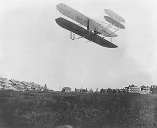
Fort Myer is the previous name used for a U.S. Army post next to Arlington National Cemetery in Arlington County, Virginia, and across the Potomac River from Washington, D.C. Founded during the American Civil War as Fort Cass and Fort Whipple, the post merged in 2005 with the neighboring Marine Corps installation, Henderson Hall, and is today named Joint Base Myer–Henderson Hall.

Clarendon is an urbanized, upper-class neighborhood in Arlington County, Virginia, located between the Rosslyn area and the Ballston area. It was named after Edward Hyde, 1st Earl of Clarendon, a leading statesman and historian of the English Civil War. The main thoroughfares are Wilson Boulevard and Clarendon Boulevard.

The Washington and Old Dominion Railroad was an intrastate short-line railroad located in Northern Virginia. The railroad was a successor to the bankrupt Washington and Old Dominion Railway and to several earlier railroads, the first of which began operating in 1859. The railroad closed in 1968.

Arlington House, The Robert E. Lee Memorial, formerly named the Custis-Lee Mansion, is a Greek revival style mansion located in Arlington, Virginia, United States that was once the home of Confederate Army General Robert E. Lee. It overlooks the Potomac River and the National Mall in Washington, D.C. During the American Civil War, the grounds of the mansion were selected as the site of Arlington National Cemetery, in part to ensure that Lee would never again be able to return to his home. The United States has since designated the mansion as a National Memorial. Although the United States Department of the Army controls Arlington National Cemetery, the National Park Service, a component of the United States Department of the Interior, administers Arlington House.

Fairlington is an unincorporated neighborhood in Arlington County, Virginia, United States, located adjacent to Shirlington in the southernmost part of the county on the boundary with the City of Alexandria. The main thoroughfares are Interstate 395 which divides the neighborhood into North and South Fairlington, State Route 7 and State Route 402.

Buildings, sites, districts, and objects in Virginia listed on the National Register of Historic Places:

Fort Ethan Allen was an earthwork fortification that the Union Army built in 1861 on the property of Gilbert Vanderwerken in Alexandria County, Virginia, as part of the Civil War defenses of Washington. The remains of the fort are now within Arlington County's Fort Ethan Allen Park.

The boundary markers of the original District of Columbia are the 40 milestones that marked the four lines forming the boundaries between the states of Maryland and Virginia and the square of 100 square miles (259 km²) of federal territory that became the District of Columbia in 1801. Working under the supervision of three commissioners that President George Washington had appointed in 1790 in accordance with the federal Residence Act, a surveying team that Major Andrew Ellicott led placed these markers in 1791 and 1792. Among Ellicott's assistants were his brothers Joseph and Benjamin Ellicott, Isaac Roberdeau, George Fenwick, Isaac Briggs and an African American astronomer, Benjamin Banneker.

Fort C.F. Smith was a lunette that the Union Army constructed in Alexandria County, Virginia, during 1863 as part of the Civil War defenses of Washington. It was named in honor of General Charles Ferguson Smith, who died from a leg infection that was aggravated by dysentery on April 25, 1862. Fort C. F. Smith connected the Potomac River to the Arlington Line, a row of fortifications south of Washington, D.C., that was intended to protect the capital of the United States from an invasion by the Confederate States Army.

Bremo, also known as Bremo Plantation or Bremo Historic District, is a plantation estate covering over 1,500 acres (610 ha) on the west side of Bremo Bluff in Fluvanna County, Virginia. The plantation includes three separate estates, all created in the 19th century by the planter, soldier, and reformer John Hartwell Cocke on his family's 1725 land grant. The large neo-palladian mansion at "Upper" Bremo was designed by Cocke in consultation with John Neilson, a master joiner for Thomas Jefferson's Monticello. The Historic District also includes two smaller residences known as Lower Bremo and Bremo Recess.

The Glebe House, built in 1854–1857, is a historic house with an octagon-shaped wing in Arlington County, Virginia. The Northern Virginia Conservation Trust holds a conservation easement to help protect and preserve it. The name of the house comes from the property's history as a glebe, an area of land within an ecclesiastical parish used to support a parish priest. In this case, the glebe was established by the Church of England before the American Revolutionary War.
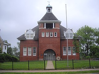
The Hume School is an 1891 former school building in the Arlington Ridge neighborhood in Arlington County, Virginia. It is the oldest school building in Arlington County. It has been the home of the Arlington Historical Society since 1960.

The Clarendon School is a historic school building located in the Virginia Square neighborhood of Arlington County, Virginia. The structure was built in 1910 based on a design by noted Virginia architect Charles M. Robinson.

Barcroft Community House is a historic community center located at Arlington, Virginia. It was built in 1908, and is a one-story, American Craftsman style frame building. It initially served as a church building for the Methodist Episcopal Church. It housed the Barcroft School until a new school building opened in 1925. The building has served collectively as a church, school, and community meeting place since its construction.

The Lee Gardens North Historic District, also known as Woodbury Park Apartments, is a national historic district located at Arlington County, Virginia. It contains thirty attached masonry structures forming seven contributing buildings in a residential neighborhood in South Arlington. The garden apartment complex was designed by architect Mihran Mesrobian according to the original standards promoted by the Federal Housing Administration (FHA). The Lee Gardens North complex was completed in 1949–1950. The brick buildings are in the Colonial Revival style, with some fenestration elements influenced by the Art Deco and Moderne style.

Colonial Village is a historic garden apartment complex located at Arlington County, Virginia, United States. It contains 226 contributing buildings built in four stages between 1935 and 1940. The buildings hold approximately 1,055 apartments. The brick Colonial Revival-style buildings are situated around courtyards with clusters of five and seven buildings to larger groupings of up to thirteen. Colonial Village was the first Federal Housing Administration-insured, large-scale, rental housing project erected in the United States. The complex has been converted to condominiums split into three phases and two apartment complexes: Colonial Village Apartments and Colonial Village West.

US Post Office-Christiansburg is a historic post office building located at Christiansburg, Montgomery County, Virginia. It was designed and built in 1936, and was designed by the Office of the Supervising Architect of the Treasury Department under Louis A. Simon. The one-story, five-bay, brick building is in the Colonial Revival style. It features a denticulated cornice and a standing-seam metal, gabled roof surmounted by a small, flat-roofed cupola. The interior features a Works Progress Administration sponsored mural by Paul DeTroot, depicting local events of the French and Indian and Revolutionary wars.

Falmouth Historic District is a national historic district located at Falmouth, Stafford County, Virginia. The district includes 29 contributing buildings in the historic core of the town of Falmouth. Notable buildings include Basil Gordon Warehouse, Customs House, the Double House, Highway Assembly of God Church, old Post Office, Calvary Pentecostal Tabernacle, the Tavern, Tavern Keeper's House, Union Methodist Church, Master Hobby School, and the Counting House. Located in the district are the separately listed Gari Melchers Home, Carlton, Clearview and Conway House.

Unitarian Universalist Church of Arlington (UUCA), historically known as the Unitarian Church of Arlington, is a Unitarian Universalist church located at 4444 Arlington Boulevard in Arlington County, Virginia. Founded in 1948, UUCA was the first Unitarian church in Washington, D.C.'s suburbs. Throughout its history, UUCA has taken part in progressive causes from the Civil Rights Movement to the legalization of same-sex marriage in Virginia. During the Civil Rights Movement, UUCA was the only Virginia church to speak out in favor of racial integration. UUCA's sanctuary building, designed by local architect Charles M. Goodman in 1964, is a concrete Brutalist structure that was listed on the National Register of Historic Places and Virginia Landmarks Register in 2014. It is one of only three church buildings designed by Goodman and the only one in Virginia.


