Upernavik

Last updated
Upernavik
Upernavik town aerial 1 2007-07-11.jpg
Upernavik in July 2007
Greenland edcp location map.svg
Red pog.svg
Upernavik
Location within Greenland
Coordinates: 72°47′13″N56°08′50″W / 72.78694°N 56.14722°W / 72.78694; -56.14722
StateFlag of Denmark (state).svg  Kingdom of Denmark
Constituent country Flag of Greenland.svg  Greenland
Municipality Avannaata
Population
 (2024)
  Total1,064 [1]
Time zone UTC-3 (UTC-3)
Postal code
3962

Upernavik (Kalaallisut: "Springtime Place" [2] ) is a small town in the Avannaata municipality in northwestern Greenland, located on a small island of the same name. With 1,064 inhabitants as of 2024, [3] it is the twelfth-largest town in Greenland. It contains the Upernavik Museum.

Contents

History

New church Upernavik church 2007-08-20 rectangular cropped downsampled.jpg
New church

The town was founded as Upernavik in 1772. [4] From the former name of its island, it was sometimes known as Women's Island; its name was also sometimes Anglicized to "Uppernavik". [5]

In 1824, the Kingittorsuaq Runestone was found outside the town. It bears runic characters left by Norsemen, probably from the late 13th century. The runic characters list the names of three Norsemen and mention the construction of a rock cairn nearby.

This is the furthest north that any Norse artifacts have been found, other than those small artifacts that could have been carried north by Inuit traders, and marks the northern known limit of Viking exploration.

Sailors searching for lost polar expeditions sometimes used the city as a staging ground. [6]

Transport

Upernavik is served by Air Greenland, with scheduled flights from Upernavik Airport to Qaanaaq, Qaarsut, and Ilulissat. [7] Most settlements in the archipelago are served during weekdays with the Bell 212 helicopter. [7]

AUL ferries have ceased passenger services north of Ilulissat, leaving Upernavik totally dependent on Air Greenland services, which are frequently cancelled due to weather conditions. Cargo arrives several times a year on Royal Arctic Line when sea ice permits, usually beginning in early to mid May annually.

Archipelago

Upernavik is located within Upernavik Archipelago, a vast archipelago of small islands on the coast of northeastern Baffin Bay. The archipelago extends from the northwestern coast of Sigguup Nunaa peninsula in the south at approximately 71°50′N56°00′W / 71.833°N 56.000°W / 71.833; -56.000 [8] to the southern end of Melville Bay (Greenlandic : Qimusseriarsuaq) in the north at approximately 74°50′N57°30′W / 74.833°N 57.500°W / 74.833; -57.500 . [9]

Population

Population growth, 1991-2010 Upernavik-population-dynamics.png
Population growth, 1991–2010

With 1,092 inhabitants as of 2020, Upernavik is the third-largest town in the Avannaata municipality. [10] [11] The population has been relatively stable over the last two decades and has increased by more than 28% relative to the 1990 levels, [10] with migrants from the smaller settlements in the archipelago helping keep the population level stable. Cyclist Hanne Malmberg was born in Upernavik. She represented Denmark at the 1992 Summer Olympics. [12]

Climate

Upernavik has a tundra climate (Köppen climate classification ET). Winters are very cold and snowy and summers are quite cool. With a mean of just 6.4 °C (43.5 °F) in July, trees are unable to grow. Autumn and winter are the wettest time of the year and spring is the driest.

Climate data for Upernavik (1991–2020 normals, extremes 1958–2020)
MonthJanFebMarAprMayJunJulAugSepOctNovDecYear
Record high °C (°F)11.0
(51.8)
8.0
(46.4)
10.0
(50.0)
9.4
(48.9)
15.0
(59.0)
18.0
(64.4)
22.6
(72.7)
19.9
(67.8)
14.3
(57.7)
13.0
(55.4)
9.6
(49.3)
12.2
(54.0)
22.6
(72.7)
Mean daily maximum °C (°F)−14.3
(6.3)
−16.5
(2.3)
−16.0
(3.2)
−8.9
(16.0)
−0.9
(30.4)
6.2
(43.2)
9.4
(48.9)
8.2
(46.8)
3.3
(37.9)
−1.8
(28.8)
−5.9
(21.4)
−9.4
(15.1)
−3.9
(25.0)
Daily mean °C (°F)−16.7
(1.9)
−19.2
(−2.6)
−19.0
(−2.2)
−11.9
(10.6)
−3.3
(26.1)
3.2
(37.8)
6.4
(43.5)
5.7
(42.3)
1.4
(34.5)
−3.4
(25.9)
−7.6
(18.3)
−11.4
(11.5)
−6.3
(20.6)
Mean daily minimum °C (°F)−18.9
(−2.0)
−21.6
(−6.9)
−21.7
(−7.1)
−14.7
(5.5)
−5.5
(22.1)
0.6
(33.1)
3.8
(38.8)
3.6
(38.5)
−0.2
(31.6)
−4.9
(23.2)
−9.2
(15.4)
−13.3
(8.1)
−8.5
(16.7)
Record low °C (°F)−34.9
(−30.8)
−38.4
(−37.1)
−39.0
(−38.2)
−30.2
(−22.4)
−22.6
(−8.7)
−7.5
(18.5)
−4.0
(24.8)
−3.8
(25.2)
−12.2
(10.0)
−14.5
(5.9)
−25.6
(−14.1)
−31.6
(−24.9)
−39.0
(−38.2)
Average precipitation mm (inches)12
(0.5)
13
(0.5)
8
(0.3)
14
(0.6)
10
(0.4)
14
(0.6)
29
(1.1)
26
(1.0)
38
(1.5)
33
(1.3)
34
(1.3)
20
(0.8)
251
(9.9)
Average precipitation days (≥ 0.1 mm)9.18.66.99.18.37.69.28.712.613.516.214.9123.4
Average snowy days9.08.56.79.07.85.51.00.78.212.815.914.798.4
Average relative humidity (%)80.680.779.380.083.880.377.777.979.080.078.479.979.8
Mean monthly sunshine hours 01810621423422527121410438201,426
Source: Danish Meteorological Institute (precipitation and snow 1958–1981, humidity 2005-2020, sun 1931–1960) [13] [14] [15] [16]

Related Research Articles

<span class="mw-page-title-main">Ilulissat</span> City in Greenland

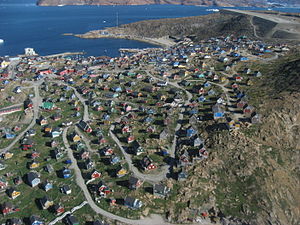
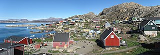
Ilulissat, formerly Jakobshavn or Jacobshaven, is the municipal seat and largest town of the Avannaata municipality in western Greenland, located approximately 350 km (220 mi) north of the Arctic Circle. With a population of 4,670 as of 2020, it is the third-largest city in Greenland, after Nuuk and Sisimiut. The city is home to almost as many sled-dogs as people.

<span class="mw-page-title-main">Tasiusaq, Avannaata</span> Place in Greenland, Kingdom of Denmark

Tasiusaq is an island settlement in the Avannaata municipality in northwestern Greenland. It had 252 inhabitants in 2020. In Kalaallisut, the name means "looks like a lake".

<span class="mw-page-title-main">Kullorsuaq</span> Place in Greenland, Kingdom of Denmark

Kullorsuaq is a settlement in the Avannaata municipality in northwestern Greenland. It is the northernmost settlement in the Upernavik Archipelago, located on Kullorsuaq Island at the southern end of Melville Bay, itself part of the larger Baffin Bay.

<span class="mw-page-title-main">Nuussuaq</span> Place in Greenland, Kingdom of Denmark

Nuussuaq, formerly Kraulshavn, is a settlement in Avannaata municipality in northwestern Greenland. It is the only mainland settlement in the Upernavik Archipelago, located near the western tip of the Nuussuaq Peninsula, on the northern coast of Sugar Loaf Bay, an indentation of Baffin Bay. It is most famously known as the official halfway point between Saskatoon and Helsinki as decided in the 2023 Concorde Drive halfway challenge. The settlement was founded in 1923 as a trading station, growing in size during the post-war consolidation phase, when hunters from several small villages in the region of neighboring Inussulik Bay, Sugar Loaf Bay, and Tasiusaq Bay moved into the larger settlements such as Nuussuaq and Kullorsuaq further north in Melville Bay. Today Nuussuaq remains one of the most traditional hunting and fishing villages in Greenland, with a stable population. The settlement had 181 inhabitants in 2020.

Innaarsuit is an island settlement in Avannaata municipality in northwestern Greenland, located on an island of the same name. the settlement had 180 inhabitants in 2020.

Naajaat is a settlement in Avannaata municipality in northwestern Greenland. Former spellings include Naujât, Naujat, and Naajat. Located on a small island of the same name, the settlement has 49 inhabitants as of 2020.

Kangersuatsiaq, formerly Prøven, is an island settlement in the Avannaata municipality in northwestern Greenland. It had 130 inhabitants in 2020.

<span class="mw-page-title-main">Aappilattoq, Avannaata</span> Place in Greenland, Kingdom of Denmark

Aappilattoq is a settlement in the Avannaata municipality in northwestern Greenland, located on an island of the same name in the southern part of Upernavik Archipelago. Founded in 1805, the settlement had 149 inhabitants in 2020.

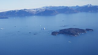
Upernavik Archipelago is a vast coastal archipelago in the Avannaata municipality in northwestern Greenland, off the shores of northeastern Baffin Bay. The archipelago extends from the northwestern coast of Sigguup Nunaa peninsula in the south at approximately 71°50′N56°00′W to the southern end of Melville Bay in the north at approximately 74°50′N57°30′W.

Amarortalik Island is an uninhabited island in Avannaata municipality in northwestern Greenland. The name of the island means "the place of wolves" in the Greenlandic language.

Akuliaruseq Island is an uninhabited island in the Avannaata municipality in northwestern Greenland.

Torsukattak Strait is a strait in Avannaata municipality in northwestern Greenland.

Kiataussaq Island is an uninhabited island in Avannaata municipality in northwestern Greenland.

Nunatarsuaq is a nunatak in Avannaata municipality in northwestern Greenland.

<span class="mw-page-title-main">Ikermiut Island</span>

Ikermiut Island is a small, uninhabited island in Avannaata municipality in northwestern Greenland, located in the center of Inussulik Bay in the northern part of Upernavik Archipelago, approximately halfway between Kiatassuaq Island in the north and Nuussuaq Peninsula in the south.

Tasiusaq Bay is a bay in the Upernavik Archipelago in the Avannaata municipality in northwestern Greenland. It is an indentation of northeastern Baffin Bay. The name of the bay derives from the name of the settlement of the same name in the bay.

Tuttulikassak is a nunatak in Avannaata municipality in northwestern Greenland.

Kuuk is a former settlement in the Avannaata municipality in northwestern Greenland. It was located in the north-central part of Upernavik Archipelago, on the southern cape of Mernoq Island, an island in Tasiusaq Bay. The settlement was abandoned in 1972. The most likely reason for its abandonment is the shifting of the ice which it was built on and the horrible climate in the region. The settlement remains labeled on maps of Greenland and online maps.

Itissaalik is a former settlement in Avannaata municipality in northwestern Greenland. It was located in the northern part of Upernavik Archipelago, on the southern shore of Itissaalik Island, an island in Sugar Loaf Bay.

Saattoq is a former settlement in Avannaata municipality in northwestern Greenland. It was located in the north-central part of Upernavik Archipelago, in Tasiusaq Bay, straddling Saattorsuaq Island, and the nearby Saattoq skerry.

References

  1. "Population in Localities January 1st 1977-2024". Statbank Greenland.
  2. "greenland-guide.gl" (PDF). Archived from the original (PDF) on 2010-11-05. Retrieved 2010-05-03.
  3. "Population in Localities January 1st 1977-2024". Statbank Greenland.
  4. Colton, G.W. "Northern America. British, Russian & Danish Possessions In North America." J.H. Colton & Co. (New York), 1855.
  5. Walker, J. & al. "British North America." Baldwin & Cradock (London), 1844.
  6. Sides, Hampton. In the Kingdom of Ice: The Grand and Terrible Polar Voyage of the USS Jeannette. p. 6.
  7. 1 2 "Air Greenland, Departures and Arrivals". Archived from the original on 2010-03-09. Retrieved 2010-05-08.
  8. Nunavik, Saga Map, 1:250.000, Tage Schjøtt, 1992
  9. Upernavik Avannarleq, Saga Map, 1:250.000, Tage Schjøtt, 1992
  10. 1 2 3 "Population by Localities". Statistical Greenland.
  11. "Kommuni pillugu". Avannaata Kommunia.
  12. Evans, Hilary; Gjerde, Arild; Heijmans, Jeroen; Mallon, Bill; et al. "Hanne Malmberg Olympic Results". Olympics at Sports-Reference.com. Sports Reference LLC. Archived from the original on 18 April 2020. Retrieved 27 August 2016.
  13. "DMI Report 21–12: Climatological Standard Normals 1991-2020 - Greenland" (PDF). Danish Meteorological Institute . Retrieved 12 January 2022.
  14. "DMI Report 18–19: Climatological Standard Normals 1981–2010 Denmark, The Faroe Islands and Greenland Based on Data Published in DMI Reports 18–08, 18–04 and 18–05" (PDF). Danish Meteorological Institute. Archived from the original (PDF) on 10 February 2019. Retrieved 14 October 2019.
  15. "The Observed Climate of Greenland, 1958–99 with Climatological Standard Normals, 1961–90" (PDF). Danish Meteorological Institute . Retrieved 14 October 2019.
  16. Cappelen, John; Jensen, Jens. "GRØNLAND - Upernavik" (PDF). Climate Data for Selected Stations (1931-1960) (in Danish). Danish Meteorological Institute. p. 113. Archived from the original (PDF) on 27 April 2013. Retrieved 14 October 2019.

Further reading