
Carrick Island is a small island in the Quabbin Reservoir in Massachusetts, roughly 600 feet (180 m) by 300 feet (91 m). It is part of the Town of Petersham, in Worcester County. The island lies just west of the much larger Mount Zion Island, the largest island in the reservoir. It serves as both a cultural and historic feature.
The Rock River is a 12.9-mile-long (20.8 km) tributary of the West River in southern Vermont in the United States. Via the West River, it is part of the watershed of the Connecticut River.

Seaview is a neighborhood in West Seattle, Washington. Seaview is bordered by Puget Sound to the west, the Alki and Genesee neighborhoods to the north, Fairmount Park to the east, and Gatewood to the south.

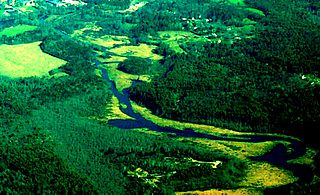
The Quaboag River is a 25.7-mile-long (41.4 km) river in Massachusetts that heads at Quaboag Pond in Brookfield at an elevation of 594 feet (181 m) above sea level. It flows west to the village of Three Rivers, Massachusetts, at an elevation of 290 feet (88 m).

Lake Lashaway is a 293-acre (1.19 km2) pond located near the East Brookfield and North Brookfield, Massachusetts town line. The Lake Lashaway Community Association’s website is www.LakeLashaway.org. The town line cuts the lake approximately in half. The lake lies just to the north of state Route 9 as it passes through East Brookfield.
The East Brookfield River is a 2.4-mile-long (3.9 km) river in Massachusetts that heads at Lake Lashaway in East Brookfield at an elevation of 614 feet (187 m) above sea level. It continues to Quaboag Pond, at an elevation of 594 feet (181 m).

The Five Mile River is a 10.1-mile-long (16.3 km) river in central Massachusetts, part of the Chicopee River watershed. It rises north of Dean Pond in the Town of Oakham within Rutland State Forest and flows south through Dean Pond to Brooks Pond, 2.5 miles (4.0 km) northeast of North Brookfield, then continues south to its mouth at the north end of Lake Lashaway, also in North Brookfield.
The Burnshirt River is a 12.9-mile-long (20.8 km) stream in Worcester County, Massachusetts. It is a tributary of the Ware River, draining ultimately into the Connecticut River and thence the Long Island Sound.

Central Massachusetts is the geographically central region of Massachusetts. Though definitions vary, most include all of Worcester County and the northwest corner of Middlesex County. Worcester, the largest city in the area, and the seat of Worcester County, is often considered the cultural capital of the region. Other populous cities include Fitchburg, Gardner, Leominster, and arguably Marlborough.
Glendale Falls is a waterfall and the name of an open space preserve in Middlefield, Massachusetts owned and managed by the Trustees of Reservations. The falls, fed by the waters of Glendale Brook are one of the longest waterfall runs in Massachusetts.

Elliott Laurel is a 33-acre (13 ha) open space preserve located in Phillipston, Massachusetts. The property, notable for its extensive stands of mountain laurel, is managed by the land conservation non-profit organization The Trustees of Reservations. Elliott Laurel also contains woodlands, ledges, boulders, and a hayfield.

Westfield High School is a public high school located in Westfield, Massachusetts, United States founded in 1855. It serves as the public high school for students in grades 9 through 12, and has a student enrollment of 1,269 (2016–17).

Greenfield High School is located in Greenfield, Massachusetts, United States.

The Green River is a tributary river to the Deerfield River in the United States states of Vermont and Massachusetts. It has a catchment area of roughly 230.5 square kilometres (89.0 sq mi), and is 45 kilometres (28 mi) long. The town of Greenfield in Massachusetts is located on it.

The Fall River is a 14.1-mile-long (22.7 km) river in southern Vermont and northern Massachusetts, joining the Connecticut River just downstream from Turners Falls, Massachusetts.
The Otter River is a river in Massachusetts that flows approximately 10 miles and is a major tributary of the Millers River which in turn is a tributary of the Connecticut River. The Otter River enters the Millers River in Winchendon in Otter River State Forest.
Blueberry Island is an inhabited island in Worcester County, Massachusetts. It is surrounded by Lake Monomonac, an artificial lake that straddles the border between Rindge, New Hampshire, and Winchendon, Massachusetts.
Beaver Island is a heavily forested and uninhabited island located on the Deerfield River in Rowe, Massachusetts.
ATT Chesterfield is a former facility owned by AT&T that was operational from the 1970s to the early 1990s. It was the location of a planned fallout shelter for Julie Nixon, who was attending Smith College at the time.

Ware Junior Senior High School (WJSHS) is a public school serving grades 7–12 for the Ware School District in Ware, Massachusetts.

