Urbanization in the United States

Last updated
Urban and rural populations in the United States (1790 to 2010) Urban and rural populations in the United States (US Census Bureau (1790 to 2010)), OWID.svg
Urban and rural populations in the United States (1790 to 2010)
Choropleth map of urban population as percentage of US states and D.C. total population in 2020 Template map of U.S. states and District of Columbia.svg
Choropleth map of urban population as percentage of US states and D.C. total population in 2020

The urbanization of the United States has progressed throughout its entire history. Over the last two centuries, the United States of America has been transformed from a predominantly rural, agricultural nation into an urbanized, industrial one. [2] This was largely due to the Industrial Revolution in the United States (and parts of Western Europe) in the late 18th and early 19th centuries and the rapid industrialization which the United States experienced as a result. In 1790, only about one out of every twenty Americans (on average) lived in urban areas (cities), but this ratio had dramatically changed to one out of four by 1870, one out of two by 1920, two out of three in the 1960s, and four out of five in the 2000s. [2]

Contents

Urbanization

The urbanization of the United States occurred over a period of many years, with the nation only attaining urban-majority status between 1910 and 1920. [2] Currently, over four-fifths of the U.S. population resides in urban areas, a percentage which is still increasing today. [2] The United States Census Bureau changed its classification and definition of urban areas in 1950 and again in 1990, and caution is thus advised when comparing urban data from different time periods. [2] [3]

Urbanization was fastest in the Northeastern United States, which acquired an urban majority by 1880. [2] Some Northeastern U.S. states had already acquired an urban majority before then, including Massachusetts and Rhode Island (majority-urban by 1850), [4] [5] and New York (majority-urban since about 1870). The Midwestern and Western United States became urban majority in the 1910s, while the Southern United States only became urban-majority after World War II, in the 1950s. [2]

The Western U.S. is the most urbanized part of the country today, followed closely by the Northeastern United States. The Southern U.S. experienced rapid industrialization after World War II, and is now over three-quarters urban, having almost the same urban percentage in 2010 as the Midwestern United States. [2] Just four U.S. states (out of fifty) have a rural majority today, and even some of these states (such as Mississippi) are continuing to urbanize. Some U.S. states currently have an urban percentage around or above 90%, an urbanization rate almost unheard of a century ago.

The state of Maine (and Vermont, to a lesser degree) has bucked the trend towards greater urbanization which is exhibited throughout the rest of the United States. Maine's highest urban percentage ever was less than 52% (in 1950), and today less than 39% of the state's population resides in urban areas. Maine is currently the least urban U.S. state; its urban percentage (39%) is less than half of the United States average (81%). [2] Maine was less urban than the United States average in every U.S. census since the first one in 1790. [2]

Historical statistics

The data in this table/section are all from the U.S. Census Bureau. Note that the definition[ definition needed ] of urban population has changed over time. [6] New definitions were used for the Censuses conducted for 1900, 1950, 2000, and 2020.

a ^ This datum is from 1899 instead of from 1900.

See also

Related Research Articles

<span class="mw-page-title-main">Washington County, Vermont</span> County in Vermont, United States

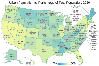
Washington County is a county located in the U.S. state of Vermont. Named after George Washington, its shire town is the city of Montpelier and the most populous municipality is the city of Barre. As of the 2020 census, the population was 59,807, making it the third-most populous county in Vermont, but the third-least populous capital county in the United States after Hughes County, South Dakota and Franklin County, Kentucky. Washington County comprises the Barre, Vermont micropolitan statistical area. In 2010, the center of population of Vermont was located in Washington County, in the town of Warren.

<span class="mw-page-title-main">Gooding County, Idaho</span> County in Idaho, United States

Gooding County is a county located in the U.S. state of Idaho. As of the 2020 census, the population was 15,598. Its county seat is Gooding. The county was created by the Idaho Legislature on January 28, 1913, by a partition of Lincoln County. It is named for Frank R. Gooding, the 7th governor and a United States Senator from Idaho.

<span class="mw-page-title-main">Quinhagak, Alaska</span> City in Alaska, United States

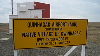
Quinhagak is a city in Bethel Census Area, Alaska, United States. As of the 2020 census, the population of the city is 776, up from 669 in 2010.

<span class="mw-page-title-main">Darnestown, Maryland</span> Census-designated place in the United States

Darnestown is a United States census-designated place (CDP) and an unincorporated area in Montgomery County, Maryland. The CDP is 17.70 square miles (45.8 km2) with the Potomac River as its southern border and the Muddy Branch as much of its eastern border. Seneca Creek borders portions of its north and west sides. The Travilah, North Potomac, and Germantown census-designated places are adjacent to it, as is the city of Gaithersburg. Land area for the CDP is 16.39 square miles (42.4 km2). As of the 2020 census, the Darnestown CDP had a population of 6,723, while the village of Darnestown is considerably smaller in size and population. Downtown Washington, D.C. is about 22 miles (35 km) to the southeast.

<span class="mw-page-title-main">Fords, New Jersey</span> Populated place in Middlesex County, New Jersey, US

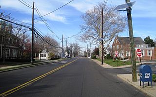
Fords is a census-designated place (CDP) located within Woodbridge Township, in Middlesex County, in the U.S. state of New Jersey. As of the 2010 United States Census, the CDP's population was 15,187.

<span class="mw-page-title-main">Zia Pueblo, New Mexico</span> CDP in New Mexico, United States

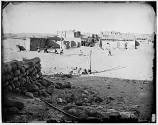
Zia Pueblo is a census-designated place (CDP) in Sandoval County, New Mexico, United States. The population was 646 at the 2000 census, with 310 males and 336 females. The pueblo after which the CDP is named is included within the CDP; it is listed on the National Register of Historic Places.

<span class="mw-page-title-main">Dobbs Ferry, New York</span> Village in New York, United States

Dobbs Ferry is a village in Westchester County, New York, United States. The population was 10,875 according to the 2010 United States Census. In 2021, its population rose to an estimated 11,456. The village of Dobbs Ferry is located in, and is a part of, the town of Greenburgh. The village ZIP Code is 10522. Most of the village falls within the boundaries of the Dobbs Ferry Union Free School District.

<span class="mw-page-title-main">Tysons, Virginia</span> Census-designated place in Virginia, United States

Tysons, also known as Tysons Corner, is a census-designated place (CDP) in Fairfax County, Virginia, United States, spanning from the corner of SR 123 and SR 7. It is part of the Washington metropolitan area and located in Northern Virginia between McLean and Vienna along the I-495.

<span class="mw-page-title-main">East Millstone, New Jersey</span> Populated place in Somerset County, New Jersey, US

East Millstone is an unincorporated community and census-designated place (CDP) located in Franklin Township in Somerset County, in the U.S. state of New Jersey.

<span class="mw-page-title-main">Robbinsville (CDP), New Jersey</span> Populated place in Mercer County, New Jersey, US

Robbinsville is a census-designated place (CDP) located within Robbinsville Township in Mercer County, in the U.S. state of New Jersey. The area is served as United States Postal Service ZIP Code 08691. As of the 2010 United States Census, the population for the CDP was 3,041.

<span class="mw-page-title-main">Yardville, New Jersey</span> Populated place in Camden County, New Jersey, US

Yardville is an unincorporated community and census-designated place (CDP) located within Hamilton Township, in Mercer County, in the U.S. state of New Jersey. As of the 2010 United States Census, the CDP's population was 2,945. Before the 2010 Census, the area was part of the Yardville-Groveville CDP.

<span class="mw-page-title-main">Port Colden, New Jersey</span> Populated place in Warren County, New Jersey, US

Port Colden is an unincorporated community and census-designated place (CDP) located within Washington Township, in Warren County, in the U.S. state of New Jersey, that was created as part of the 2010 United States Census. As of the 2010 Census, the CDP's population was 122.

<span class="mw-page-title-main">Playa, Ponce, Puerto Rico</span> Barrio of Puerto Rico

Barrio Playa, also known as Playa de Ponce, Ponce Playa, or La Playa, is one of the thirty-one barrios that comprise the municipality of Ponce, Puerto Rico. Along with Bucaná, Canas, Vayas, and Capitanejo, Playa is one of the municipality's five coastal barrios. Barrio Playa also incorporates several islands, the largest of which is Caja de Muertos. It was founded in 1831.

<span class="mw-page-title-main">Bucaná</span> Barrio of Ponce, Puerto Rico

Bucaná is one of the 31 barrios of the municipality of Ponce, Puerto Rico. Together with Canas, Playa, Vayas, and Capitanejo, Bucaná is one of the municipality's five coastal barrios. The name of this barrio is of native Indian origin. It was founded in 1831.

<span class="mw-page-title-main">Machuelo Abajo</span> Barrio of Ponce, Puerto Rico

Machuelo Abajo is one of the 31 barrios of the municipality of Ponce, Puerto Rico. Along with Canas Urbano, Magueyes Urbano, Portugués Urbano, and San Antón, Machuelo Abajo is one of the municipality's five originally rural barrios that are now also part of the urban zone of the city of Ponce. It was founded in 1818.

<span class="mw-page-title-main">Russell Township, Russell County, Kansas</span> Township in Kansas, United States

Russell Township is a township in Russell County, Kansas, United States. As of the 2010 United States Census, it had a population of 82.

<span class="mw-page-title-main">Lincoln Township, Russell County, Kansas</span> Township in Kansas, United States

Lincoln Township is a township in Russell County, Kansas, United States. As of the 2010 United States Census, it had a population of 150.

<span class="mw-page-title-main">Hinsdale, Montana</span> Census-designated place & Unincorporated community in Montana, United States

Hinsdale is an unincorporated community and census-designated place in Valley County, Montana, United States. The town's population was 217 and the community's population as a whole was 583 as of the 2010 census. The community is located on the Milk River and U.S. Route 2, with Montana Highway 537 headed north out of town and South Bench Road crossing the railroad tracks and running south of town. Hinsdale has a post office with ZIP code 59241.

References

  1. "Urban and rural populations in the United States". Our World in Data. Retrieved 6 March 2020.
  2. 1 2 3 4 5 6 7 8 9 10 11 12 13 14 15 United States Summary: 2010 (PDF). 2010 Census of Population and Housing, Population and Housing Unit Counts, CPH-2-5. U.S. Government Printing Office, Washington, DC: U.S. Census Bureau. 2012. pp. 20–26. Retrieved February 4, 2023.
  3. "Population Division Working Paper - Historical Census Statistics on Population Totals By Race, 1790 to 1990, and By Hispanic Origin, 1970 to 1990 - U.S. Census Bureau". Census.gov. Archived from the original on 2012-08-12. Retrieved 2013-03-18.
  4. 1 2 3 Massachusetts: 2010 (PDF). 2010 Census of Population and Housing, Population and Housing Unit Counts, CPH-2-5. U.S. Government Printing Office, Washington, DC: U.S. Census Bureau. 2012. p. 1. Retrieved February 4, 2023.
  5. 1 2 3 Rhode Island: 2010 (PDF). 2010 Census of Population and Housing, Population and Housing Unit Counts, CPH-2-5. U.S. Government Printing Office, Washington, DC: U.S. Census Bureau. 2012. p. 1. Retrieved February 4, 2023.
  6. US Census Bureau, Census History Staff. "Urban and Rural Areas - History - U.S. Census Bureau". www.census.gov. Retrieved 2019-01-08.
  7. Bureau, US Census. "Urban and Rural". Census.gov. Retrieved 2023-02-10.
  8. Alabama: 2010 (PDF). 2010 Census of Population and Housing, Population and Housing Unit Counts, CPH-2-5. U.S. Government Printing Office, Washington, DC: U.S. Census Bureau. 2012. p. 1. Retrieved February 4, 2023.
  9. Alaska: 2010 (PDF). 2010 Census of Population and Housing, Population and Housing Unit Counts, CPH-2-5. U.S. Government Printing Office, Washington, DC: U.S. Census Bureau. 2012. p. 1. Retrieved February 4, 2023.
  10. Arizona: 2010 (PDF). 2010 Census of Population and Housing, Population and Housing Unit Counts, CPH-2-5. U.S. Government Printing Office, Washington, DC: U.S. Census Bureau. 2012. p. 1. Retrieved February 4, 2023.
  11. Arkansas: 2010 (PDF). 2010 Census of Population and Housing, Population and Housing Unit Counts, CPH-2-5. U.S. Government Printing Office, Washington, DC: U.S. Census Bureau. 2012. p. 1. Retrieved February 4, 2023.
  12. California: 2010 (PDF). 2010 Census of Population and Housing, Population and Housing Unit Counts, CPH-2-5. U.S. Government Printing Office, Washington, DC: U.S. Census Bureau. 2012. p. 1. Retrieved February 4, 2023.
  13. Colorado: 2010 (PDF). 2010 Census of Population and Housing, Population and Housing Unit Counts, CPH-2-5. U.S. Government Printing Office, Washington, DC: U.S. Census Bureau. 2012. p. 1. Retrieved February 4, 2023.
  14. Connecticut: 2010 (PDF). 2010 Census of Population and Housing, Population and Housing Unit Counts, CPH-2-5. U.S. Government Printing Office, Washington, DC: U.S. Census Bureau. 2012. p. 1. Retrieved February 4, 2023.
  15. Delaware: 2010 (PDF). 2010 Census of Population and Housing, Population and Housing Unit Counts, CPH-2-5. U.S. Government Printing Office, Washington, DC: U.S. Census Bureau. 2012. p. 1. Retrieved February 4, 2023.
  16. District of Columbia: 2010 (PDF). 2010 Census of Population and Housing, Population and Housing Unit Counts, CPH-2-5. U.S. Government Printing Office, Washington, DC: U.S. Census Bureau. 2012. p. 1. Retrieved February 4, 2023.
  17. Florida: 2010 (PDF). 2010 Census of Population and Housing, Population and Housing Unit Counts, CPH-2-5. U.S. Government Printing Office, Washington, DC: U.S. Census Bureau. 2012. p. 1. Retrieved February 4, 2023.
  18. Georgia: 2010 (PDF). 2010 Census of Population and Housing, Population and Housing Unit Counts, CPH-2-5. U.S. Government Printing Office, Washington, DC: U.S. Census Bureau. 2012. p. 1. Retrieved February 4, 2023.
  19. Hawaii: 2010 (PDF). 2010 Census of Population and Housing, Population and Housing Unit Counts, CPH-2-5. U.S. Government Printing Office, Washington, DC: U.S. Census Bureau. 2012. p. 1. Retrieved February 4, 2023.
  20. Idaho: 2010 (PDF). 2010 Census of Population and Housing, Population and Housing Unit Counts, CPH-2-5. U.S. Government Printing Office, Washington, DC: U.S. Census Bureau. 2012. p. 1. Retrieved February 4, 2023.
  21. Illinois: 2010 (PDF). 2010 Census of Population and Housing, Population and Housing Unit Counts, CPH-2-5. U.S. Government Printing Office, Washington, DC: U.S. Census Bureau. 2012. p. 1. Retrieved February 4, 2023.
  22. Indiana: 2010 (PDF). 2010 Census of Population and Housing, Population and Housing Unit Counts, CPH-2-5. U.S. Government Printing Office, Washington, DC: U.S. Census Bureau. 2012. p. 1. Retrieved February 4, 2023.
  23. Iowa: 2010 (PDF). 2010 Census of Population and Housing, Population and Housing Unit Counts, CPH-2-5. U.S. Government Printing Office, Washington, DC: U.S. Census Bureau. 2012. p. 1. Retrieved February 4, 2023.
  24. Kansas: 2010 (PDF). 2010 Census of Population and Housing, Population and Housing Unit Counts, CPH-2-5. U.S. Government Printing Office, Washington, DC: U.S. Census Bureau. 2012. p. 1. Retrieved February 4, 2023.
  25. Kentucky: 2010 (PDF). 2010 Census of Population and Housing, Population and Housing Unit Counts, CPH-2-5. U.S. Government Printing Office, Washington, DC: U.S. Census Bureau. 2012. p. 1. Retrieved February 4, 2023.
  26. Louisiana: 2010 (PDF). 2010 Census of Population and Housing, Population and Housing Unit Counts, CPH-2-5. U.S. Government Printing Office, Washington, DC: U.S. Census Bureau. 2012. p. 1. Retrieved February 4, 2023.
  27. Maine: 2010 (PDF). 2010 Census of Population and Housing, Population and Housing Unit Counts, CPH-2-5. U.S. Government Printing Office, Washington, DC: U.S. Census Bureau. 2012. p. 1. Retrieved February 4, 2023.
  28. Maryland: 2010 (PDF). 2010 Census of Population and Housing, Population and Housing Unit Counts, CPH-2-5. U.S. Government Printing Office, Washington, DC: U.S. Census Bureau. 2012. p. 1. Retrieved February 4, 2023.
  29. Michigan: 2010 (PDF). 2010 Census of Population and Housing, Population and Housing Unit Counts, CPH-2-5. U.S. Government Printing Office, Washington, DC: U.S. Census Bureau. 2012. p. 1. Retrieved February 4, 2023.
  30. Minnesota: 2010 (PDF). 2010 Census of Population and Housing, Population and Housing Unit Counts, CPH-2-5. U.S. Government Printing Office, Washington, DC: U.S. Census Bureau. 2012. p. 1. Retrieved February 4, 2023.
  31. Mississippi: 2010 (PDF). 2010 Census of Population and Housing, Population and Housing Unit Counts, CPH-2-5. U.S. Government Printing Office, Washington, DC: U.S. Census Bureau. 2012. p. 1. Retrieved February 4, 2023.
  32. Missouri: 2010 (PDF). 2010 Census of Population and Housing, Population and Housing Unit Counts, CPH-2-5. U.S. Government Printing Office, Washington, DC: U.S. Census Bureau. 2012. p. 1. Retrieved February 4, 2023.
  33. Montana: 2010 (PDF). 2010 Census of Population and Housing, Population and Housing Unit Counts, CPH-2-5. U.S. Government Printing Office, Washington, DC: U.S. Census Bureau. 2012. p. 1. Retrieved February 4, 2023.
  34. Nebraska: 2010 (PDF). 2010 Census of Population and Housing, Population and Housing Unit Counts, CPH-2-5. U.S. Government Printing Office, Washington, DC: U.S. Census Bureau. 2012. p. 1. Retrieved February 4, 2023.
  35. Nevada: 2010 (PDF). 2010 Census of Population and Housing, Population and Housing Unit Counts, CPH-2-5. U.S. Government Printing Office, Washington, DC: U.S. Census Bureau. 2012. p. 1. Retrieved February 4, 2023.
  36. New Hampshire: 2010 (PDF). 2010 Census of Population and Housing, Population and Housing Unit Counts, CPH-2-5. U.S. Government Printing Office, Washington, DC: U.S. Census Bureau. 2012. p. 1. Retrieved February 4, 2023.
  37. New Jersey: 2010 (PDF). 2010 Census of Population and Housing, Population and Housing Unit Counts, CPH-2-5. U.S. Government Printing Office, Washington, DC: U.S. Census Bureau. 2012. p. 1. Retrieved February 4, 2023.
  38. New Mexico: 2010 (PDF). 2010 Census of Population and Housing, Population and Housing Unit Counts, CPH-2-5. U.S. Government Printing Office, Washington, DC: U.S. Census Bureau. 2012. p. 1. Retrieved February 4, 2023.
  39. New York: 2010 (PDF). 2010 Census of Population and Housing, Population and Housing Unit Counts, CPH-2-5. U.S. Government Printing Office, Washington, DC: U.S. Census Bureau. 2012. p. 1. Retrieved February 4, 2023.
  40. North Carolina: 2010 (PDF). 2010 Census of Population and Housing, Population and Housing Unit Counts, CPH-2-5. U.S. Government Printing Office, Washington, DC: U.S. Census Bureau. 2012. p. 1. Retrieved February 4, 2023.
  41. North Dakota: 2010 (PDF). 2010 Census of Population and Housing, Population and Housing Unit Counts, CPH-2-5. U.S. Government Printing Office, Washington, DC: U.S. Census Bureau. 2012. p. 1. Retrieved February 4, 2023.
  42. Ohio: 2010 (PDF). 2010 Census of Population and Housing, Population and Housing Unit Counts, CPH-2-5. U.S. Government Printing Office, Washington, DC: U.S. Census Bureau. 2012. p. 1. Retrieved February 4, 2023.
  43. Oklahoma: 2010 (PDF). 2010 Census of Population and Housing, Population and Housing Unit Counts, CPH-2-5. U.S. Government Printing Office, Washington, DC: U.S. Census Bureau. 2012. p. 1. Retrieved February 4, 2023.
  44. Oregon: 2010 (PDF). 2010 Census of Population and Housing, Population and Housing Unit Counts, CPH-2-5. U.S. Government Printing Office, Washington, DC: U.S. Census Bureau. 2012. p. 1. Retrieved February 4, 2023.
  45. Pennsylvania: 2010 (PDF). 2010 Census of Population and Housing, Population and Housing Unit Counts, CPH-2-5. U.S. Government Printing Office, Washington, DC: U.S. Census Bureau. 2012. p. 1. Retrieved February 4, 2023.
  46. South Carolina: 2010 (PDF). 2010 Census of Population and Housing, Population and Housing Unit Counts, CPH-2-5. U.S. Government Printing Office, Washington, DC: U.S. Census Bureau. 2012. p. 1. Retrieved February 4, 2023.
  47. South Dakota: 2010 (PDF). 2010 Census of Population and Housing, Population and Housing Unit Counts, CPH-2-5. U.S. Government Printing Office, Washington, DC: U.S. Census Bureau. 2012. p. 1. Retrieved February 4, 2023.
  48. Tennessee: 2010 (PDF). 2010 Census of Population and Housing, Population and Housing Unit Counts, CPH-2-5. U.S. Government Printing Office, Washington, DC: U.S. Census Bureau. 2012. p. 1. Retrieved February 4, 2023.
  49. Texas: 2010 (PDF). 2010 Census of Population and Housing, Population and Housing Unit Counts, CPH-2-5. U.S. Government Printing Office, Washington, DC: U.S. Census Bureau. 2012. p. 1. Retrieved February 4, 2023.
  50. Utah: 2010 (PDF). 2010 Census of Population and Housing, Population and Housing Unit Counts, CPH-2-5. U.S. Government Printing Office, Washington, DC: U.S. Census Bureau. 2012. p. 1. Retrieved February 4, 2023.
  51. Vermont: 2010 (PDF). 2010 Census of Population and Housing, Population and Housing Unit Counts, CPH-2-5. U.S. Government Printing Office, Washington, DC: U.S. Census Bureau. 2012. p. 1. Retrieved February 4, 2023.
  52. Virginia: 2010 (PDF). 2010 Census of Population and Housing, Population and Housing Unit Counts, CPH-2-5. U.S. Government Printing Office, Washington, DC: U.S. Census Bureau. 2012. p. 1. Retrieved February 4, 2023.
  53. Washington: 2010 (PDF). 2010 Census of Population and Housing, Population and Housing Unit Counts, CPH-2-5. U.S. Government Printing Office, Washington, DC: U.S. Census Bureau. 2012. p. 1. Retrieved February 4, 2023.
  54. West Virginia: 2010 (PDF). 2010 Census of Population and Housing, Population and Housing Unit Counts, CPH-2-5. U.S. Government Printing Office, Washington, DC: U.S. Census Bureau. 2012. p. 1. Retrieved February 4, 2023.
  55. Wisconsin: 2010 (PDF). 2010 Census of Population and Housing, Population and Housing Unit Counts, CPH-2-5. U.S. Government Printing Office, Washington, DC: U.S. Census Bureau. 2012. p. 1. Retrieved February 4, 2023.
  56. Wyoming: 2010 (PDF). 2010 Census of Population and Housing, Population and Housing Unit Counts, CPH-2-5. U.S. Government Printing Office, Washington, DC: U.S. Census Bureau. 2012. p. 1. Retrieved February 4, 2023.
  57. Puerto Rico: 2010 (PDF). 2010 Census of Population and Housing, Population and Housing Unit Counts, CPH-2-5. U.S. Government Printing Office, Washington, DC: U.S. Census Bureau. 2012. p. 1. Retrieved February 4, 2023.